

Mar 12: Shutdown Winter Storm Expected!
A late-winter KABOOM is expected for many NJ areas tomorrow night into Tuesday. Here’s our latest thoughts…
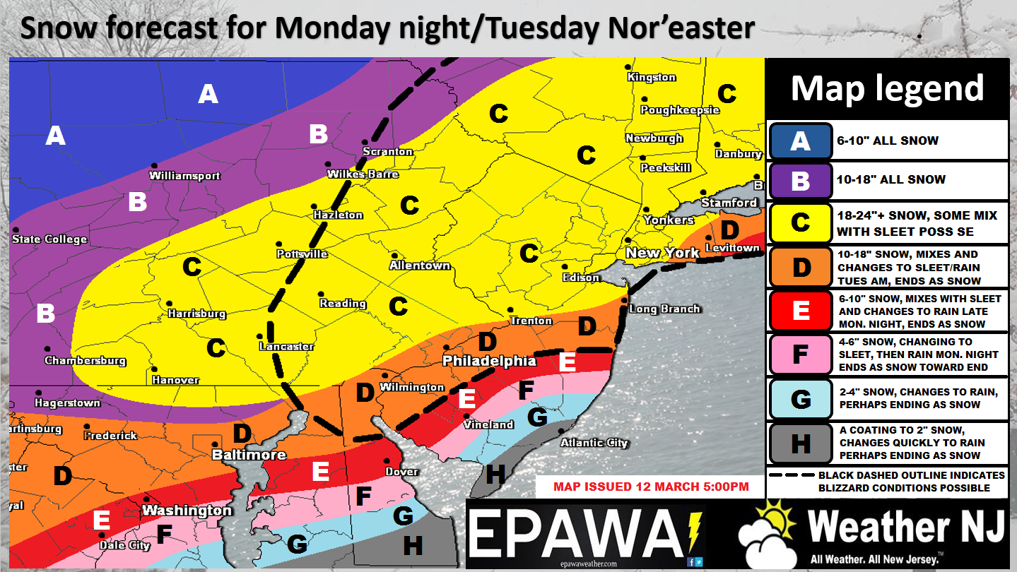
Please click here to view full-resolution winter storm impact map.
Disco: 3 pieces of energy (cyclonic vorticity) are moving into the E US, from the N and W, as two northern shortwaves and remnants of the winter storm that just hit the SE US. The northernmost piece of energy (polar shortwave) will phase with the middle piece (Pacific shortwave) and develop a favorable longwave trough axis for the southernmost piece to eventually and also phase in as the entire trough tilts negative. The W US is modeled with a very amped ridge which correlates to a deeper trough downstream for the E US. This all translates to an environment favorable for a major, possibly historic, winter storm. While areas away from the ocean will see the biggest snows, coastal regions have flooding and beach erosion to worry about due to higher astronomical tides (coming off a full moon) + storm surge associated with strong onshore flow. Let’s break it down even further…
Snow: I’m pretty confident in areas away from the ocean seeing a foot plus of snow and therefore the KABOOM alarm has been sounded. Some guidance is suggesting 18-24 inches and therefore we’ll upgrade to “Dude where’s my car?” if that happens. But for now…KABOOM! The latest guidance trends have brought the heavier snow jackpot axis SE of the I-95 corridor which is reflected in our 2nd call map above. However, we are still weary of the SENJ coast due to late-seasonal climatology + sun angle + strong onshore warm flow off the ocean. Heavier precipitation rates can overcome these conditions however that’s expecting a lot this time of year. The map above represents our most reasonable and rational call given all things considered but I will add the caveat that SENJ numbers could go up for our final call tomorrow/during the storm if we think it’s warranted. There’s explosive snowfall potential across the entire state but the SENJ area should see the least amount relative to points NW. Blizzard criteria will be met if sustained winds of 35mph along with 1/4 mile visibility can last for 3 hours. As the map above reflects, this is possible for the entire black-dashed line.
Mixing: I’m fairly confident that at least extreme SENJ will mix during peak onshore flow late Monday night into Tuesday morning. Therefore, we’re probably going to watch the snow/rain line first move inland over Cape May/Atlantic City from SE to NW and then eventually pull back and away as the deformation zone sets up. That means snow to mix to rain to mix to snow is possible as far inland as the I-95 corridor but for at least Atlantic City down through Cape May and Cumberland Counties. How far this snow/rain line comes inland mid-storm represents one of the most difficult aspects of this forecast. We’ll do our best to have the best estimation possible for our final call tomorrow. This is what can make the difference between significant and major snowfall for SENJ. There are no mixing concerns to the NW of the I-95 corridor as far as New Jersey goes.
Coastal Flooding: Tidal guidance is picking up on the flooding potential for Tuesday. The late-Tuesday morning high tide appears to be the highest water level of the storm. The Tuesday evening high tide should then be the second highest water level of the storm. Right now, at least moderate levels of coastal flooding and beach erosion should be expected. Tidal guidance has not yet suggested major coastal flooding but it’s hard for me to believe that’s not possible given the wind field and wind gust potential. The Jersey shore, Raritan Bay, and Long Island coasts are looking at wind gusts up to/in-excess of 60mph with sustained winds of 25-35mph. That should push a lot of water onshore and into the back bays of the barrier islands.
Power Outages: This snow should be heavy and wet, especially on the SE side of the jackpot. Therefore excessive weight could stack up on tree branches, power lines, etc. Couple that with high winds and it’s a recipe for scattered-to-widespread power outages. I strongly suggest having some blankets and winter gear to stay warm should you loose your source of heat/power. I would imagine the coast would be most susceptible to this given the higher expected winds but power outages are a threat state-wide.
Wildcards: There’s a lot of room for curveballs with this complex of a setup. An earlier phase and trough tilt would bring warmer condition as far inland as the I-95 corridor and cripple accumulation capability. A later phase would mean lesser snow totals (still significant-to-major) but possibly not historic. There’s also the possibility that the strongest frontogenic forcing/lifting stays both to our W in W PA and to our E over the ocean. These uprights of rising air would force sinking air between (over us) which could inhibit the historic scenario from occurring. Again, a significant-to-major snow storm would still be possible but not the historic scenario. The bottom line on wildcards is that there are many. Multiple vorts are involved in phasing and therefore timing is critical. We’ll try to expand on this for the final call tomorrow and will immediately post anything that is detected during live observations. These wildcards come with the game and remind us that meteorology is not a guaranteed scientific principal like gravity. It’s an incomplete data set that we do our best to utilize for prediction.
Timing: We’re going with a general start time of 8PM to Midnight Monday night (tomorrow night) from SW to NE across NJ. The meat and potatoes of the storm should then occur through most of Tuesday before letting up Tuesday evening. Isolated show showers would then be possible overnight into Wednesday with strong and cold NW flow over the Great Lakes.
In English: KABOOM my friends. KABOOM! The above map represents our current expected totals for the upcoming Monday PM-Tuesday PM winter storm. SENJ totals could increase tomorrow for our final call if we think precipitation rates are going to overcome climatology, sun angle and onshore flow. Otherwise everyone to the N and W of a line drawn from Brick to the Delaware Memorial Bridge are in good shape for a foot plus of snow. Winds will be high, especially along the coast, and therefore flooding and beach erosion are very likely. Power outages are also likely considering the heavy wet snow coupled with the previously mentioned winds. Our final call will be released tomorrow and then live-casting will begin with radar/satellite observations. This is our second call for now. Have a great night and please be safe.
Jonathan Carr (JC) is the founder and sole operator of Weather NJ, New Jersey’s largest independent weather reporting agency. Since 2010, Jonathan has provided weather safety discussion and forecasting services for New Jersey and surrounding areas through the web and social media. Originally branded as Severe NJ Weather (before 2014), Weather NJ is proud to bring you accurate and responsible forecast discussion ahead of high-stakes weather scenarios that impact this great garden state of ours. All Weather. All New Jersey.™ Be safe! JC


LOCAL FORECAST | INTERACTIVE RADAR | LATEST NJ WEATHER ALERTS | WEDDING FORECAST| PRIVACY POLICY
© Copyright 2026 Weather NJ LLC. All Rights Reserved.
Some information that can be found on our website is provided by a private weather station and is not an officially recognized station for weather reporting. Though we always strive to achieve accurate reporting for our own use, it is important that you do NOT depend on the data provided here for any purpose.
