

Mar 15: Watching Sunday-Monday System
The most noticeable trend on today’s models was the eastward shift of the storm’s track. This is now being modeled as more of an offshore/coastal system rather than an inland runner/coastal hugger. That means that the low pressure system would form near the SE US coast and move N/NE, grazing OBX and passing closer to the benchmark (40N/-70W). We have many days to go until Sunday and more trending is expected. But this is how it looks right now.
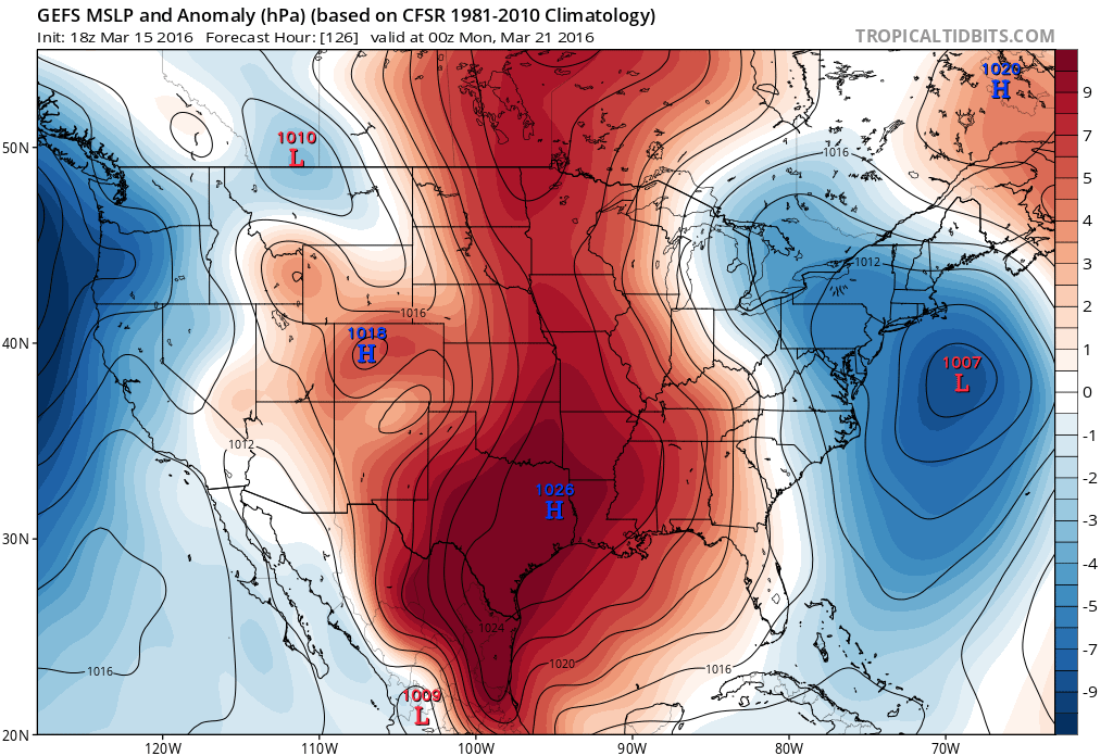
Here’s the latest GFS ensemble mean showing the low’s modeled location on Sunday evening:
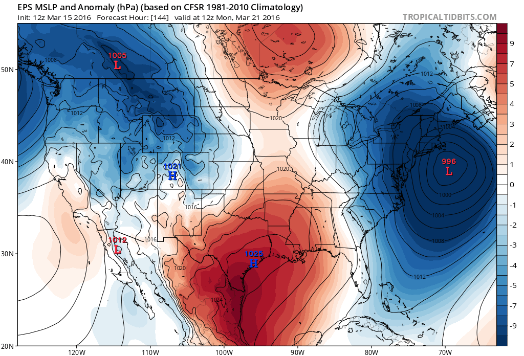
Here is the European ensemble mean showing the low’s modeled location on Monday morning:
The offshore track would mean a few things One, it could completely miss out to sea. Two, it could just graze New Jersey with the NW side of its precipitation shield. Precipitation could then fall in the form of snow but melt on contact due to warmer surface temperatures. Three, it could trend a little closer to the coast and snow at a higher rate. Such a scenario could over-power the surface like we saw a few weeks ago in SENJ. Lastly, it could track closer to the coast which would mean a rain solution for most of New Jersey with maybe the NWNJ elevations seeing snow. The bottom line is that it is too soon to lock into a track just yet.
For now, I’m interested in the consistency of the ensembles showing a low pressure system in the said area. There should be a much more confident idea of storm track by as early as Thursday night but definitely by Friday night. The timing has been pretty consistent on potential impact with a Sunday-Monday window. We’ll have to keep an eye on any coastal flooding impacts from the system if onshore flow is intense enough. I’d say that’s more important than the possible wet snow that could struggle to accumulate.

In English: I’m watching a coastal storm system in the Sunday-Monday period. There’s a chance it could bring mixed precipitation types to New Jersey. Whether rain or wet snow struggling to accumulate, coastal flooding is possible if the storm tracks close enough to the shore. We’re still a bit out with plenty of tracking to go, so for now just watching and discussing. Be safe! JC
Jonathan Carr (JC) is the founder and sole operator of Weather NJ, New Jersey’s largest independent weather reporting agency. Since 2010, Jonathan has provided weather safety discussion and forecasting services for New Jersey and surrounding areas through the web and social media. Originally branded as Severe NJ Weather (before 2014), Weather NJ is proud to bring you accurate and responsible forecast discussion ahead of high-stakes weather scenarios that impact this great garden state of ours. All Weather. All New Jersey.™ Be safe! JC


LOCAL FORECAST | INTERACTIVE RADAR | LATEST NJ WEATHER ALERTS | WEDDING FORECAST| PRIVACY POLICY
© Copyright 2026 Weather NJ LLC. All Rights Reserved.
Some information that can be found on our website is provided by a private weather station and is not an officially recognized station for weather reporting. Though we always strive to achieve accurate reporting for our own use, it is important that you do NOT depend on the data provided here for any purpose.
