

Mar 17: Snow Storm Likely!
Model guidance continues to converge on a snow storm solution for the east coast this Sunday-Monday. Expected accumulation amounts are a little tricky to pin down at this exact moment but tomorrow evening I’ll have a very detailed storm impact map for you. This will give me enough time to review crucial model data as we transition from the mid-range to short-range forecasting period. I can however, tell you what I’m currently thinking.
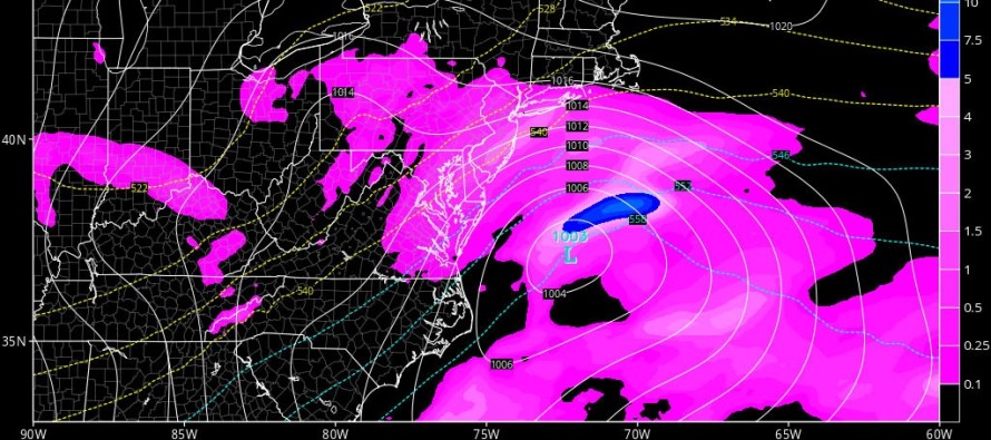
The global models and their ensemble members have been pretty consistent on a W US ridge ahead of an upper-level low-driven E US trough this weekend. They have also been very consistent on a surface low developing in the SE US and riding up the coast towards the benchmark (40N/-70W). Lastly, they have been consistent with weak blocking and a perfectly timed high pressure to the north of the low. The models have differed on timing and the exact track of the low (W of benchmark, over benchmark, or E of benchmark) as well as how soon the upper-level trough tilt’s negative.
The timing matters most because if snowfall occurs when the sun is up on Sunday, it will likely have trouble sticking on the roads. You will have way more snow falling than ultimately accumulates. The sun-angle is much higher than a few months ago and can therefore penetrate to the surface more easily, even through clouds. If this happens then we could see an epic white rain storm (snow melting on contact). Should snowfall occur later Sunday night when the sun is down, then more of the snow will have a chance to accumulate, even on roads. I’ll be watching the timing on model guidance very closely for this reason.
The track wobble that’s been modeled just W and E of the benchmark can mean the difference between an I-95 and NW jackpot (like the Euro is locked on to) or a SENJ jackpot (like the GFS currently likes). The former would likely start at least SENJ with rain that changes over to light accumulations. The latter would mean light, possibly significant accumulations for everyone along and SE of the I-95 corridor. So that’s the other major thing I’ll be watching very closely—how much interaction the upper-level low has with the track. The modeled trough axis tomorrow night should be pretty close to how it’s going to be. I think I’ll have a good enough handle on this and timing tomorrow evening for my initial snow map. In the meantime, bask in the uncertainty while embracing the consistency 8)

In English: A snow storm (possibly rain to snow for those SE of the turnpike) is likely this Sunday into Monday. The heaviest area of snow is wobbling between NWNJ and SENJ on the models but regardless, something between that is likely coming. I will have my initial snow map with exact timing and expected accumulations posted around this time (8:30PM) tomorrow evening. I need to see the model data between now and then to make the most confident call I can. Thanks for your patience and understanding. Have a great night and be safe! JC
Jonathan Carr (JC) is the founder and sole operator of Weather NJ, New Jersey’s largest independent weather reporting agency. Since 2010, Jonathan has provided weather safety discussion and forecasting services for New Jersey and surrounding areas through the web and social media. Originally branded as Severe NJ Weather (before 2014), Weather NJ is proud to bring you accurate and responsible forecast discussion ahead of high-stakes weather scenarios that impact this great garden state of ours. All Weather. All New Jersey.™ Be safe! JC


LOCAL FORECAST | INTERACTIVE RADAR | LATEST NJ WEATHER ALERTS | WEDDING FORECAST| PRIVACY POLICY
© Copyright 2026 Weather NJ LLC. All Rights Reserved.
Some information that can be found on our website is provided by a private weather station and is not an officially recognized station for weather reporting. Though we always strive to achieve accurate reporting for our own use, it is important that you do NOT depend on the data provided here for any purpose.
