

Mar 17: Weekend Snow Map
Here’s our wintry expectations for the weekend…
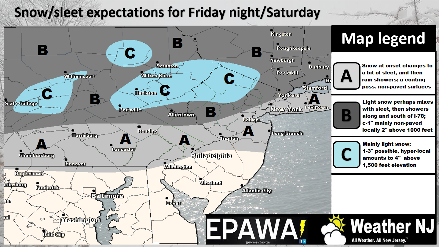
Please click here for full-resolution impact map.
Disco: This map covers the precipitation that will move in early tomorrow morning ahead of the warm front and linger through tomorrow evening. This map does not include any additional snowfall that might fall Saturday night into Sunday morning from the potential inverted trough. That will have to be nowcasted but would only result in an additional few inches on top of the above map and mainly for NNJ only (N of I-78). Given the eastward departing nature of the inverted trough, NENJ and the NYC area would actually have a better chance. Areas like Long Island and southern-coastal New England have the best chance. The southern 2/3 of New Jersey is likely looking at mostly rain, some sleet and/or non-accumulating snow. This is now the second half of March with a marginal surface temperature boundary so accumulations are going to struggle under light snowfall. It would take very heavy snowfall like the recent winter storm to overcome the surface and we’re just not seeing it at this time. All snow and rainfall should wrap-up by noon and Sunday and that might be all she wrote for Winter 2016-2017 impact (aside from the flurries and snow showers that can happen through early April).
In English: Precipitation should move into the region early tomorrow and taper off by noon on Sunday. The above map represents snowfall through tomorrow night. Although the map states Friday night through Saturday night (remember EPAWA is included in this), NJ timing is likely early Saturday morning through Saturday night.
Since the additional snowfall possibility (tomorrow night into Sunday) revolves around a highly-uncertain inverted trough coming to fruition, that will have to be now-casted. If it happens then we can probably add a few more inches for NNJ, specifically the NENJ/NYC (N of I-78) area. It will be difficult for snow to accumulate on roadways given the time of year and marginal surface temperature profile, despite the colder air aloft. I’m not enthused about anything more than a few inches accumulating on roads, even for NNJ. Natural surface could do better but who cares, right? CNJ and SNJ should see mostly rain, sleet and/or non-accumulating snow. With that said, this system is rather weak overall and likely only plowable N of I-80 for some areas, maybe N of I-78. Everyone S of I-78 should expect little road disruption as surface temperatures will be above 32. It is worth noting however that the system could end Sunday morning with a burst of snow. The greatest imapct would be visibility reduction, not disruptive accumulations.
This might be all she wrote for accumulating snowfall in New Jersey. Pretty fitting since Monday is the first day of spring. Have a great weekend and please be safe! JC
Jonathan Carr (JC) is the founder and sole operator of Weather NJ, New Jersey’s largest independent weather reporting agency. Since 2010, Jonathan has provided weather safety discussion and forecasting services for New Jersey and surrounding areas through the web and social media. Originally branded as Severe NJ Weather (before 2014), Weather NJ is proud to bring you accurate and responsible forecast discussion ahead of high-stakes weather scenarios that impact this great garden state of ours. All Weather. All New Jersey.™ Be safe! JC


LOCAL FORECAST | INTERACTIVE RADAR | LATEST NJ WEATHER ALERTS | WEDDING FORECAST| PRIVACY POLICY
© Copyright 2026 Weather NJ LLC. All Rights Reserved.
Some information that can be found on our website is provided by a private weather station and is not an officially recognized station for weather reporting. Though we always strive to achieve accurate reporting for our own use, it is important that you do NOT depend on the data provided here for any purpose.
