

Mar 18: Weekend Outlook and Snow Map
Friday night (Mar 18) temperatures should drop into the 30s for most of the state. NNJ elevations could drop into the 20s. Winds should be light out of the N/NW.
Saturday (Mar 19) high temperatures should reach the mid-40s statewide. Most of the day should be okay however precipitation could start as rain or a rain/snow mix before midnight. See impact map below. Winds should begin picking up out of the E/NE and gradually shift to the NE once the low moves counter-clockwise from our 6 to our 4. Coastal areas should see higher gusts heading into Sunday morning. Overnight lows should fall into the 20s for NNJ and 30s for the rest of the state.
Sunday (Mar 20) high temperatures should fail to escape the 30s for most. I could see maybe Cape May/Atlantic/Cumberland reaching 40. Snow is possible for most with SNJ/SENJ (possibly CNJ) likely to see rain first. See impact map below. Winds should be gusty and rock from the NE to our NW as the low moves counter-clockwise from our 4 to our 2. Overnight lows should fall into the 20s and 30s. The storm should wrap up by the early AM hours of Monday at the latest.
The following map represents my thoughts. So that there is no confusion, each color in the legend has two lines of text to the right of it. The top line is how much snow will fall out of the sky. The bottom line is how I expect the roads to be:
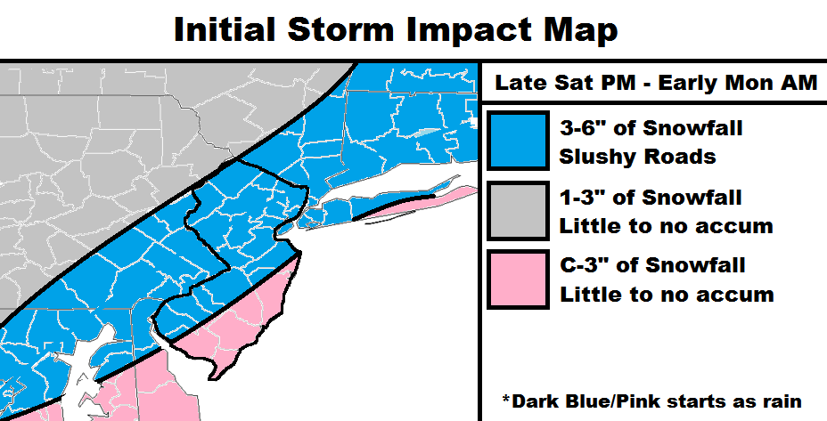
The gray area should see light snowfall. If snowfall rates become heavy enough then accumulations are likely on natural surfaces but not much on roads, especially those well-traveled.
The blue area should see the heaviest rates of snowfall from this system. Precipitation could start as rain for the first part of the system, especially along and SE of I-95. Rain should then change over to snow. I believe up to 6 inches can fall out of the sky here however seasonal climatology/sun angle/etc. will be fighting accumulations on the ground. For this reason, I believe the roads could see a slushy coating to a few slushy inches max. Well-traveled roads should see less than side roads and might only be wet. Greater accumulations on natural surfaces are possible but whatever, right? If snow is still ripping into early Monday AM then maybe it could start to stack up. My gut feel says we will wrap up before midnight though.
The pink area is the most likely area to start as rain and last area to change to snow. Therefore, lesser accumulations than the blue area are expected. The extreme SENJ coast could possibly stay all rain.
Minor coastal flooding is possible but nothing crazy. The latest marine guidance suggests tides 5 to 6.5 feet above MLLW and a storm surge of 2 feet. A run-of-mill coastal storm.

In English: A ghost storm of white rain is upon us. This is because most snow will happen during Sunday daylight hours. A decent amount of snow will fall however not all of it will stick to the ground, especially on roads and paved surfaces. It’s a rain-to-snow situation. Rain could start as early as late Saturday evening. Rain should then change to snow for Sunday (exact time of that still unknown) and wrap up by early Monday AM, if not by Sunday evening. There’s a chance a portion of SENJ stays all rain. The immediate coast would have the best chance of that. The only way we over-perform is if the snowfall lingers into the AM hours of Monday. Right now, I think we finish up by late Sunday PM.
I in no way wish to downplay the travel hazard by telling you that roads will be only wet/slushy. Please use caution as it could still get slippery. People will be people (myself included) on the roads, especially when snow is falling out of the sky. Let’s get this nonsens over with so we can get back to our nice spring. I’ll post an update tomorrow evening and then it’s now-casting time. Have a great night and be safe! JC
Image by me
Jonathan Carr (JC) is the founder and sole operator of Weather NJ, New Jersey’s largest independent weather reporting agency. Since 2010, Jonathan has provided weather safety discussion and forecasting services for New Jersey and surrounding areas through the web and social media. Originally branded as Severe NJ Weather (before 2014), Weather NJ is proud to bring you accurate and responsible forecast discussion ahead of high-stakes weather scenarios that impact this great garden state of ours. All Weather. All New Jersey.™ Be safe! JC


LOCAL FORECAST | INTERACTIVE RADAR | LATEST NJ WEATHER ALERTS | WEDDING FORECAST| PRIVACY POLICY
© Copyright 2026 Weather NJ LLC. All Rights Reserved.
Some information that can be found on our website is provided by a private weather station and is not an officially recognized station for weather reporting. Though we always strive to achieve accurate reporting for our own use, it is important that you do NOT depend on the data provided here for any purpose.
