

Mar 24: Watching Thursday for Thunderstorms
Low pressure will cut through the Ohio Valley and pass to our north this Thursday. It will help usher through a trailing cold front to the south through New Jersey. This should result in above average temperatures, widespread rain showers, and possibly scattered thunderstorms.
This next image represents surface CAPE (Convective Available Potential Energy), a parameter used to gauge instability in the atmosphere. While normally levels less than 800 j/kg (joules per kilogram) are discarded during peak warmer months, levels above 500 j/kg this time of year can produce thunderstorms. Here is the high-res NAM showing surface CAPE Thursday afternoon:
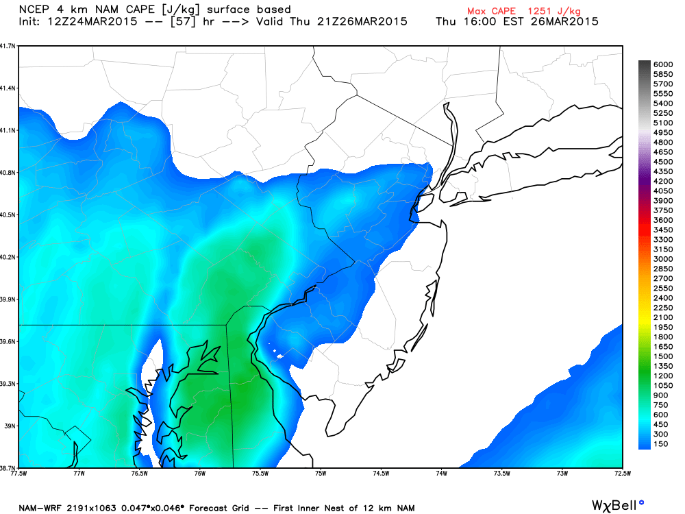
Surface CAPE is not always the best parameter to use for predicting thunderstorms. MLCAPE (Mixed Level Convective Available Potential Energy) is actually a better way to profile multiple levels of atmospheric instability, not just the surface. Another thunderstorm parameter commonly used to predict thunderstorms is called shear. Shear is the change in wind direction from the surface through the upper levels of the atmosphere. The higher the shear, the better chance of updraft and downdraft enhancement which can assist in thunderstorm development. A good rule of thumb (9 times out of 10) is that high CAPE values tend to meet severe thunderstorm criteria for hail size. Frequent lightning is also associated with high CAPE values but not part of severe thunderstorm criteria (go figure). Shear, on the other hand, tends to meet severe thunderstorm criteria for winds exceeding 58mph and often tornado criteria for rotation. So if we have a day with high CAPE and low shear, expect pulsating thunderstorms on radar with frequent lightning and/or hail. If we have a day with low CAPE and high shear, expect windy rain with embedded thunderstorms. If we have a day with both high CAPE and shear values, expect powerful thunderstorms with the kitchen sink (high winds, frequent lightning, hail, and possibly tornadoes.
Moving forward, the following thermodynamic diagram, generated from the sounding of the above NAM, indicates a MLCAPE value of 748.5 j/g, even higher than the estimated surface-based CAPE. This diagram also indicates 0-8 km shear greater than 50 kts.
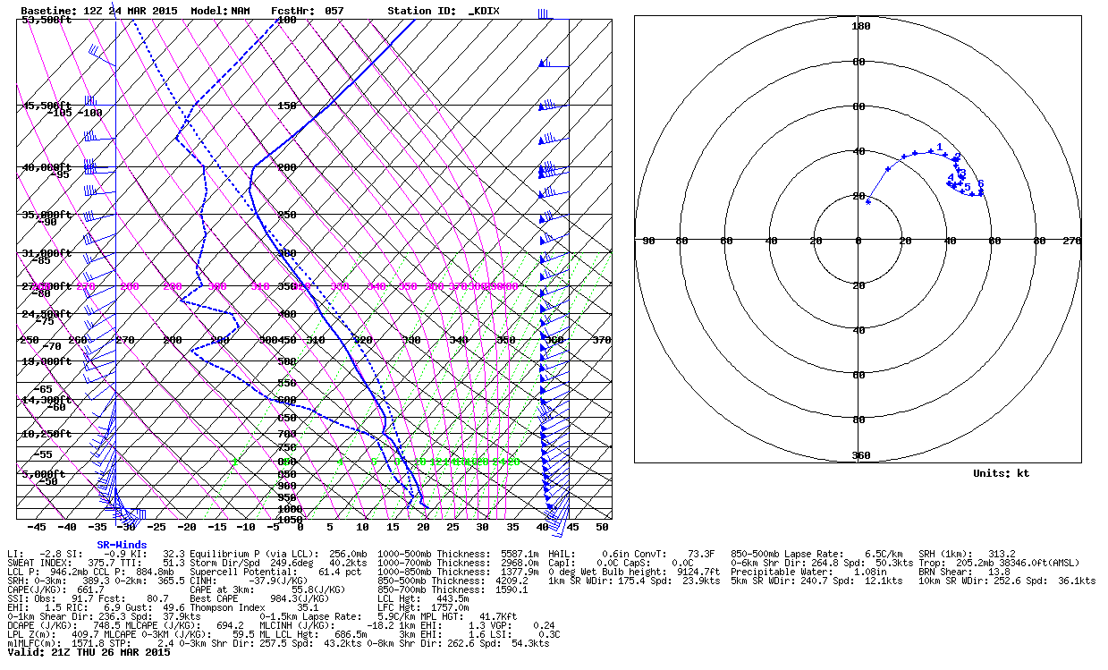
So we have an environment with marginal CAPE and decent shear. This leads me to believe that scattered thunderstorms should generally meet strong criteria with a few isolated instances of severe criteria being met not off the table. For a NWS severe thunderstorm warning to be triggered, either wind gusts must exceed 58mph and/or hail must reach 1 inch or more in diameter.
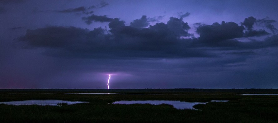
In English: Expect temperatures well into the 60s and possibly even breaking 70 (lower elevations) this Thursday. Expect widespread rainfall with scattered thunderstorms ahead of the cold front, which should pass through New Jersey between afternoon and evening. Thunderstorms could produce high wind gusts and possibly hail in localized instances. For the most part, they should be normal boomers embedded within widespread rainfall. Interior CNJ and SNJ has the best chance with higher elevations of NNJ and immediate coastal areas the least. It will all clear by Thursday night as cooler air moves into place to set up a chilly weekend. I’ll have the weekend outlook posted by Thursday evening. I took the main article image last year on Cedar Run Dock Road. Be safe! JC
Jonathan Carr (JC) is the founder and sole operator of Weather NJ, New Jersey’s largest independent weather reporting agency. Since 2010, Jonathan has provided weather safety discussion and forecasting services for New Jersey and surrounding areas through the web and social media. Originally branded as Severe NJ Weather (before 2014), Weather NJ is proud to bring you accurate and responsible forecast discussion ahead of high-stakes weather scenarios that impact this great garden state of ours. All Weather. All New Jersey.™ Be safe! JC


LOCAL FORECAST | INTERACTIVE RADAR | LATEST NJ WEATHER ALERTS | WEDDING FORECAST| PRIVACY POLICY
© Copyright 2026 Weather NJ LLC. All Rights Reserved.
Some information that can be found on our website is provided by a private weather station and is not an officially recognized station for weather reporting. Though we always strive to achieve accurate reporting for our own use, it is important that you do NOT depend on the data provided here for any purpose.
