

Mar 3: Friday Snow Map

Here is my wintry impact map heading into tonight:
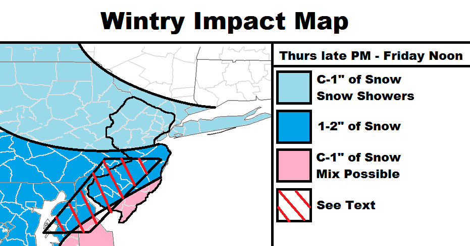
The light blue area should see snow showers with no mixing. A coating to an inch is possible.
The darker blue area should see the most accumulations from this system. 1-2 inches of wet snow is possible. Accumulations will have a better chance to stack up on natural surfaces than on paved surfaces. Mixing is possible for extreme SE areas of this color but most should stay all snow.
The pink area is most subject to a period of mixing and even all rain, especially once the sun is up tomorrow morning combining with onshore flow. With that said, a slushy coating to an inch of snow is possible with roads likely just wet once the sun is up. The better chance for stickage exists before sunrise but that will be determined by snowfall rates. Light snowfall won’t produce much of anything but heavier snowfall could stack up. I’d say this area presents some uncertainty because of such.
The See Text region has a small chance of over-performance. This area is far enough away from the coast for onshore flow impact but still under the heaviest modeled snowfall. Even though the surface line of freezing is modeled to run through CNJ, far SENJ should have trouble getting above 35. It wouldn’t take that strong of a snow band to over-power and cool the surface. Therefore, 2 inches could be slightly exceeded in this area if, and only if, heavier rates of precipitation occur from heavy mesoband lifting. Thundersnow could be an audible confirmation that this has happened. Otherwise if there is no additional lifting than this region is subject to the more confident general C-1/1-2 indicated by the rest of the map behind it.

Timing: Snow could start as early as 8PM this evening but likely by midnight. It should then spread from SW to NE and snow through at least sunrise for all of New Jersey and possibly noon for parts of CNJ and all of SNJ. NNJ should be first to taper off while SENJ tapers off last as the low pulls away. Anything that has accumulated by sunrise-noon should melt quickly in the afternoon-evening hours.
In English: A light snow event is possible tonight through tomorrow around noon. Only light accumulations are expected statewide with possibly a little more in the red-striped area on the snow map. The overall theme should be more snow falling than actually sticks. Since this will be centered around a rapidly intensifying coastal storm system, gusty winds are likely, especially along the shore. Minor coastal flooding is possible during onshore flow tomorrow morning but should subside once the low pulls away. I’ll likely make observational posts tonight and tomorrow morning. Have a great day and be safe! JC
Jonathan Carr (JC) is the founder and sole operator of Weather NJ, New Jersey’s largest independent weather reporting agency. Since 2010, Jonathan has provided weather safety discussion and forecasting services for New Jersey and surrounding areas through the web and social media. Originally branded as Severe NJ Weather (before 2014), Weather NJ is proud to bring you accurate and responsible forecast discussion ahead of high-stakes weather scenarios that impact this great garden state of ours. All Weather. All New Jersey.™ Be safe! JC


LOCAL FORECAST | INTERACTIVE RADAR | LATEST NJ WEATHER ALERTS | WEDDING FORECAST| PRIVACY POLICY
© Copyright 2026 Weather NJ LLC. All Rights Reserved.
Some information that can be found on our website is provided by a private weather station and is not an officially recognized station for weather reporting. Though we always strive to achieve accurate reporting for our own use, it is important that you do NOT depend on the data provided here for any purpose.
