

Mar 3: Snow Storm Detected!
Here is my snow map for Wednesday evening into Thursday. This includes only snow that falls after the changeover from rain to ice to snow tomorrow evening:
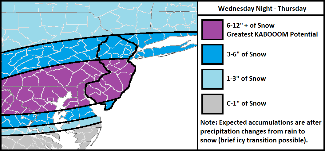
Only light snow is expected today (nothing serious) before changing to sleet/freezing rain and then ultimately rain this evening. Rain should then last through most of a warm tomorrow (on-and-off showers) before changing back to a brief period of ice and then ultimately accumulating snow. Moderate to heavy snow should then fall from tomorrow afternoon/evening well into Thursday.
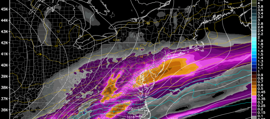
A very weak low pressure disturbance will be riding an Arctic frontal boundary that will be slowly sinking southward through all of New Jersey. This will allow strong bands of snow to form over CNJ and SNJ just north of the boundary. NNJ should still see light to moderate snowfall but faces a potential sharp cutoff to the NW due to Arctic high-reinforced dry air mass. With that being said, we’re looking at a CNJ/SNJ jackpot scenario with the potential for someone to hit 12″ of snow accumulation. My official KABOOOM will not come until that has happened but keep in mind, a decent amount of model guidance is showing it. Also keep in mind that colder temperatures in the mid and upper layers should result in snow ratios slightly greater than 10:1 (snow inches to liquid inches).
In English: After rain changes back to ice and then snow tomorrow evening, expect 6-12″+ for CNJ/SNJ and lesser amounts for NNJ. The length of icing is still uncertain but if temperatures are going to crash as anticipated, it shouldn’t be too long. The above map is pretty straightforward otherwise. As far as timing goes, I anticipate the changeover to happen within a few hours of sunset tomorrow evening. That will start the snowy period that should taper off by noon on Thursday. Be safe! JC
Jonathan Carr (JC) is the founder and sole operator of Weather NJ, New Jersey’s largest independent weather reporting agency. Since 2010, Jonathan has provided weather safety discussion and forecasting services for New Jersey and surrounding areas through the web and social media. Originally branded as Severe NJ Weather (before 2014), Weather NJ is proud to bring you accurate and responsible forecast discussion ahead of high-stakes weather scenarios that impact this great garden state of ours. All Weather. All New Jersey.™ Be safe! JC


LOCAL FORECAST | INTERACTIVE RADAR | LATEST NJ WEATHER ALERTS | WEDDING FORECAST| PRIVACY POLICY
© Copyright 2026 Weather NJ LLC. All Rights Reserved.
Some information that can be found on our website is provided by a private weather station and is not an officially recognized station for weather reporting. Though we always strive to achieve accurate reporting for our own use, it is important that you do NOT depend on the data provided here for any purpose.
