

Mar 9: Final Snow Map
Here’s our final call for snowfall ending tomorrow afternoon…
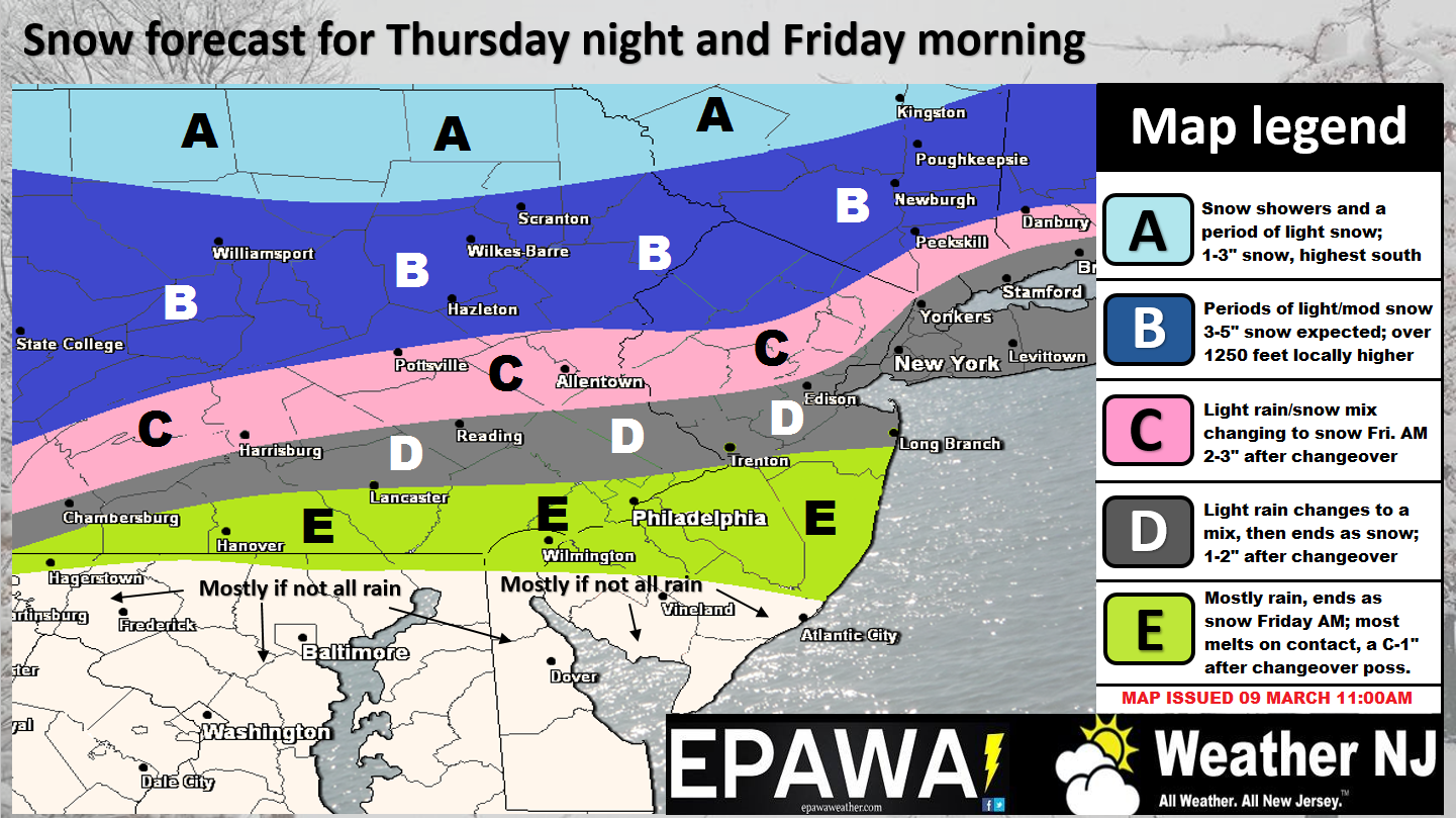
Click here to view full resolution snow map.
Disco: A weaker wave of low pressure will traverse a frontal boundary through the Ohio Valley and Mid-Atlantic US between overnight tonight and tomorrow afternoon. We have energy approaching from the NW and moisture available from the S that will meet in the middle and drop light accumulations across the region. We’re seriously fighting climatology and sun-angle (after 10AM tomorrow) with this late-winter wave. Therefore, I expect a lot more snow to fall than actually accumulates. Maybe 1/3 to 1/2 of all snow that falls actually accumulates kind of thing with the least amount of accumulation on roads. Also this is a rain to snow event for many. NNJ should see a shorter period of initial rain with more snow to finish. SNJ might stay mostly rain and end as snow. Let’s use I-195 for that general divider but that would probably have 20-30 miles N or S of variance. Regardless, it should all taper off by tomorrow afternoon with light accumulations through NNJ and possibly just trace accumulations for SNJ as our map above indicates. You might find we are on the lower end of what you’re seeing elsewhere. Again, the theme will be a warmer surface where more snow falls than actually accumulates. I expect lots of disappointment from snow lovers, especially S of I-195 and probably S of I-78. Therefore, the I-80 and N area should see the jackpot of accumulations, whatever they pan out to.
The Monday PM into Wednesday AM system has far more interest to me as a disruptive period of snowfall. While models currently have a strong consensus on the storm happening from 120 hours out…there are a lot of things that could go wrong. We’re dealing with precision phase timing of multiple energy streams that have to perform just right to get a major snow storm. Think back to January of 2015 and Hermine. Similar (obviously not exact) complex dynamics are at play. Therefore, I’m going to allow the models to do their thing through most of Saturday and just discuss the potential. On Sunday morning, if the current scenario is still showing on model guidance with correlating live observations…then it will be time to sound the alarms with much more certainty. For now, just know that a disruptive winter storm is a possibility for that time-frame and that we’re watching it very closely.
In English: I can’t drill it any harder that surface accumulations will be less than the actual amount of snow that falls through the air onto a very marginal surface. Otherwise expect rain initially overnight tonight before changing to snow early tomorrow morning and ending as snow tomorrow afternoon. NNJ should feature the shortest period of initial rain and therefore higher accumulations. SNJ should expect a longer period of rain and therefore the least amount of accumulation. With the heaviest snowfall expected to fall in NNJ and CNJ tomorrow between sunrise and late-morning, I would expect some travel issues for any untreated roads N of I-78. Everyone S of I-195 and probably even closer to I-78 and S should expect more snow on natural surfaces than roads. The map above is straight-forward and represents the most rational call we can make heading into this immediate system.
If the Monday PM into Wednesday AM winter storm is still aggressively modeled like it is now (on this coming Sunday morning) then it will be time to prepare for it. Until then, let’s watch it evolve. Everyone knows about the possibility by now. From hereon in, it’s all about making a patient and accurate forecast while considering the widest range of possibilities.
Live obervations for tomorrow’s system will begin overnight tonight. Have a great evening and please be safe! JC
Jonathan Carr (JC) is the founder and sole operator of Weather NJ, New Jersey’s largest independent weather reporting agency. Since 2010, Jonathan has provided weather safety discussion and forecasting services for New Jersey and surrounding areas through the web and social media. Originally branded as Severe NJ Weather (before 2014), Weather NJ is proud to bring you accurate and responsible forecast discussion ahead of high-stakes weather scenarios that impact this great garden state of ours. All Weather. All New Jersey.™ Be safe! JC


LOCAL FORECAST | INTERACTIVE RADAR | LATEST NJ WEATHER ALERTS | WEDDING FORECAST| PRIVACY POLICY
© Copyright 2026 Weather NJ LLC. All Rights Reserved.
Some information that can be found on our website is provided by a private weather station and is not an officially recognized station for weather reporting. Though we always strive to achieve accurate reporting for our own use, it is important that you do NOT depend on the data provided here for any purpose.
