

March 1: Dangerous Situation Unfolding
Rain Map:
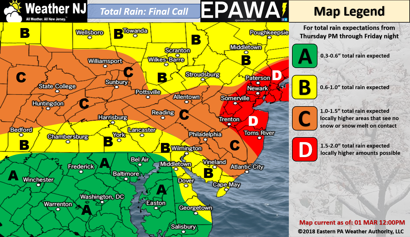
Please click here for full-resolution rain map!
Wind Map:
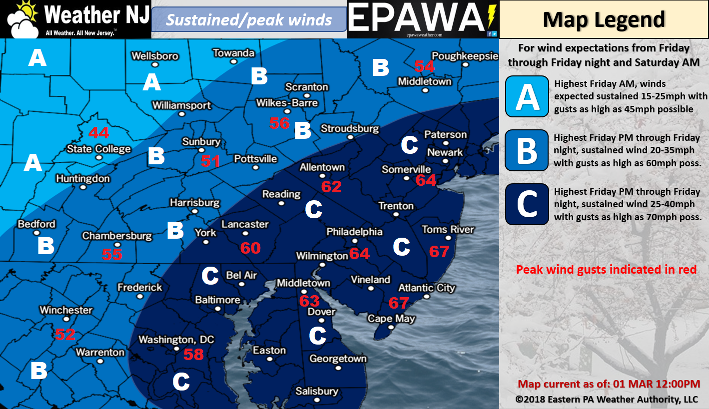
Please click here for full-resolution wind map!
Snow Map:
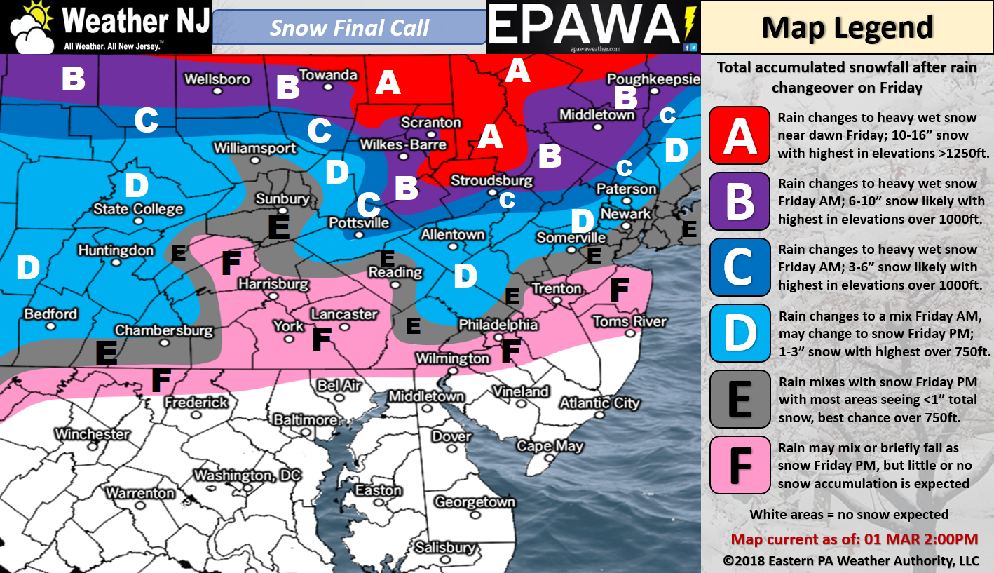
Please click here for full-resolution snow map!
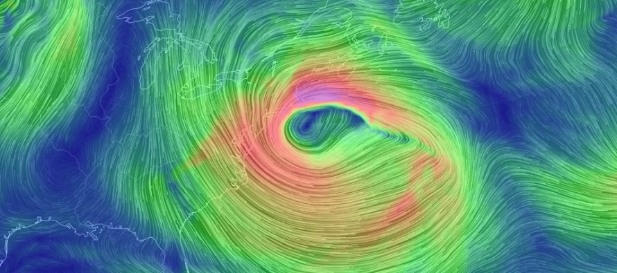
Discussion: Two upper-level shortwaves will merge near the E Great Lakes area and form a strong 500mb cut-off low. This upper-level low should track from the E Great Lakes through ~Delmarva and out into the ocean. The upper-level low should then stall near the 40N/70W benchmark, after encountering a strong -NAO block, before tracking S/SE towards Bermuda. A large area of upper-level air surrounding the cut-off low should drop below 540dam which is cold enough to support wintry precipitation if dynamics can bring the cold air down.
At the surface, the primary low should track towards the Ohio/W PA area before transferring to a secondary coastal low near the benchmark and ultimately also track S/SE towards Bermuda. Conditions tonight through tomorrow morning do not appear hazardous. During this initial period we only have onshore flow starting to develop with widespread light-to-moderate rainfall. It won’t be until closer to noon tomorrow that the winds really begin cranking out of the N. From noon tomorrow through Saturday morning however, winds should be very strong out of the N/NE with sustained winds of 35-40mph and gusts up to 70mph. Winds should subside by Saturday evening but still be noticeable through Sunday.
The greatest flooding risk appears to be from Friday evening through Sunday evening with the worst period occurring Saturday morning. That’s 5 high tides capable of producing moderate-to-major coastal flooding. Some of the values I’m seeing aren’t too far off from Sandy/1962 levels. I’m not forecasting near-Sandy/1962 levels of coastal flooding but I am including them as the upper-range of possibilities. We should all expect moderate-to-major coastal flooding from this nor’easter. We are likely beyond the risk of only minor coastal flooding criteria being met. Some of you should already notice higher-than-normal high tides today.
NNJ has the best chance to Kaboom with snow totals. That would be along and N of I-78 (maybe only along and N of I-80) and especially the higher elevations of NWNJ. I can’t fully bank on a Kaboom for NNJ but I’m fairly confident that’s where the jackpot of at least significant snow totals will fall. For the lower 2/3 of NJ (S of I-78), the snow forecast is simply too difficult to nail down. You have cold air aloft with a marginal surface where the storm itself can cool the air and then overpower the warmer surface with high precipitation rates. Too many dynamics to give you a tight window value of snow accumulations. Our above snow map is the best we can do regarding such but snowfall will have to be live-casted. I will say that the further S you are of I-78 (and the closer you are to the coast), the lesser chance you have for accumulating snowfall on paved surfaces.
In English: A powerful and likely dangerous nor’easter is approaching. Expect periods of moderate-to-heavy rain at first (tonight through tomorrow), high winds with 60-70mph gusts possible (tomorrow late-morning through Saturday afternoon), heavy wet snowfall tomorrow afternoon through Saturday morning (NNJ favored over SNJ) and moderate-to-major coastal flooding Friday and Saturday (note: full moon Friday). Widespread power outages are likely given the high winds and possible heavy wet snow that could stack up on branches and power lines. This is a very difficult forecast given the extensive dynamics. Expect an overall moderate-to-historic nor’easter. Prepare for historic. Hope for moderate. That’s about as good as we can do heading into this mess. Live-casting begins later tonight. Be safe! JC
For comprehensive and interactive hyper-local analysis that goes way above and beyond the detail of this public forecast, check out our premium services which include hyper-local text notifications from and guaranteed forum discussion with myself and Eastern PA Weather Authority (EPAWA).
Jonathan Carr (JC) is the founder and sole operator of Weather NJ, New Jersey’s largest independent weather reporting agency. Since 2010, Jonathan has provided weather safety discussion and forecasting services for New Jersey and surrounding areas through the web and social media. Originally branded as Severe NJ Weather (before 2014), Weather NJ is proud to bring you accurate and responsible forecast discussion ahead of high-stakes weather scenarios that impact this great garden state of ours. All Weather. All New Jersey.™ Be safe! JC


LOCAL FORECAST | INTERACTIVE RADAR | LATEST NJ WEATHER ALERTS | WEDDING FORECAST| PRIVACY POLICY
© Copyright 2026 Weather NJ LLC. All Rights Reserved.
Some information that can be found on our website is provided by a private weather station and is not an officially recognized station for weather reporting. Though we always strive to achieve accurate reporting for our own use, it is important that you do NOT depend on the data provided here for any purpose.
