

March 1: Significant Snowfall Detected!
Click here for full-resolution snow map!
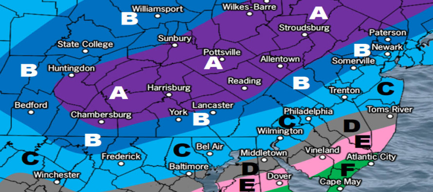
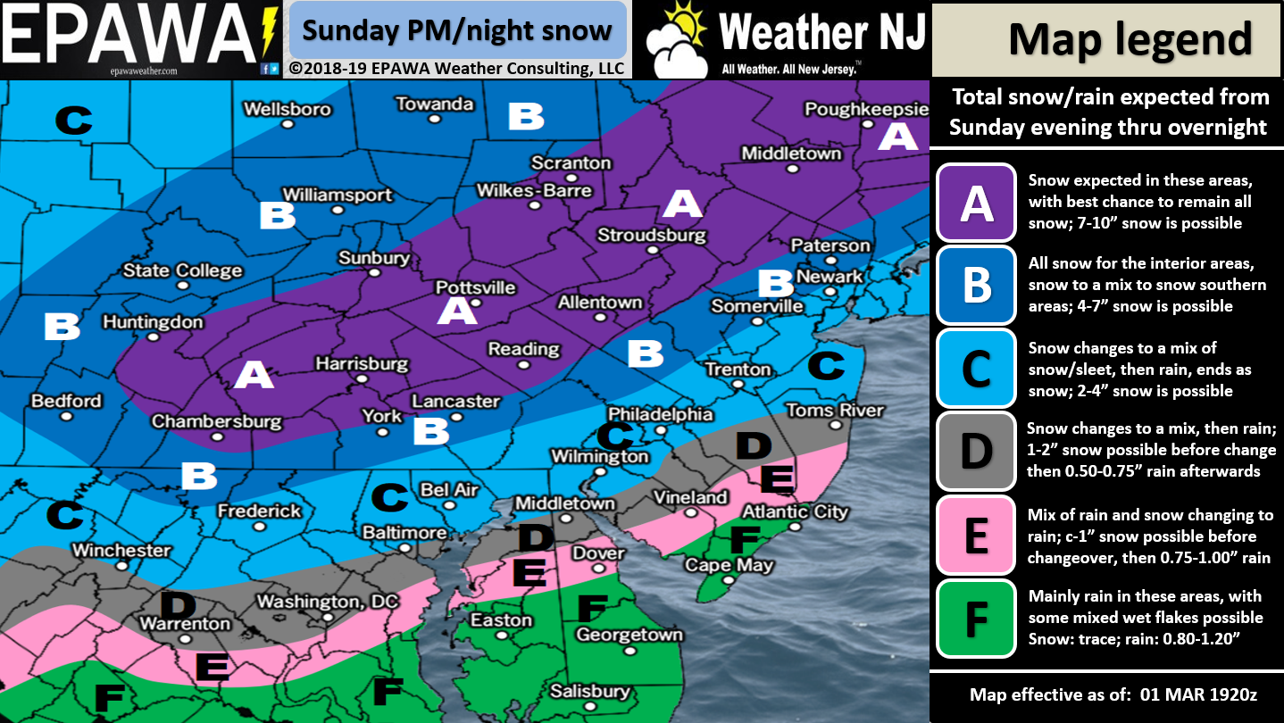
Discussion: Wave #2 will move through tonight bringing snow along and NW of the NJTP/I-95 corridor and rain SE of such. All attention will then turn to the largest of the three events Sunday night into Monday. For this system we have a large deep trough moving in so plenty of cold air in the upper-levels to mix in and cool the entire system overall. Dynamic cooling is very much on the table with a deepening 990mb low SE/near NJ. We also have the coldest sea surface temperatures of the year which should inhibit the marine onshore flow from warming most of NJ. The marine flow might only warm SENJ coastal areas as the 37F air over the ocean moves onshore initially and then drops below freezing once slightly inland. Areas further N along the Jersey Shore would stand to see less marine flow warming than S areas like Cape May/Atlantic Counties.
Tonight’s system, like all systems in the N hemisphere, features a counter-clockwise rotating low. Once tonight’s low moves offshore and strengthens it will pull down geopotential heights in it’s wake for NJ. This will allow some of the tropospheric polar vortex injection in and push the system #3 highway S. The stronger tonight’s system wraps up offshore the more of NJ gets in on the bigger snow Sunday night into Monday. However the further S the jackpot snow areas verify the lesser they will be due to a more progressive nature of system flow. The Euro is in a camp by itself with the furthest NW track. This could produce a Kaboom for NWNJ if verified verbatim. Mostly all other model guidance has higher snow accumulation potential for NENJ/CNJ/SNJ but more in the 6-10 range not the 12+ Kaboom range.
I personally think this system will verify colder and snowier than our current map above but I need some data evidence to back it. I’ll be looking for that in tonight’s overnight data suite. I feel like NWNJ is pretty much a lock for a significant all-snow solution. I feel like SENJ is pretty much a lock for rain inhibiting snow accumulations. The I-95 corridor (NJTP) is the area of highest uncertainty. It could go either way (like NWNJ or SENJ). We need another day of data and live obs analysis to produce a more confident forecast for that I-95/NJTP battleground area. For now the above snow map is the best evidence-based blend of model guidance and upstream live observations.
Two more wintry signals exist in the near-future. March 9 and 11. After that we should flip to a spring pattern by the ides of March. The sun angle is growing. Overnight snow is not affected by this but certainly any snow that falls during the day. The Sunday-Monday threat mostly occurs overnight so likely not an issue. We are rapidly gaining daylight however and it only becomes more of a problem the further into March you get.
In English: Monday morning is going to be ugly for travel. Snow and rain move in by about ~10pm Sunday night and clears by late-morning/early-afternoon Monday with the Monday AM rush hour right in the heart of precipitation. I see many closings and cancellations happening along and NW of the turnpike Monday. Areas SE of the turnpike seem manageable but still possibly disruptive especially if the system verifies colder. I have the gut feel that the system will verify colder than our current map above. Not cold enough to bring big snow all the way to the SENJ coast (zones E and F) but possibly cold enough to increase accumulations along and SE of the turnpike (zones C and D). We’ll take another shot at a map tomorrow once we see overnight and tomorrow’s model guidance and live observations out W. Download the new free Weather NJ mobile app on Apple and/or Android. It’s the easiest way to never miss Weather NJ content. Our premium services go even further above and beyond at the hyperlocal level. Have a great rest of your Tuesday and please be safe! JC
Jonathan Carr (JC) is the founder and sole operator of Weather NJ, New Jersey’s largest independent weather reporting agency. Since 2010, Jonathan has provided weather safety discussion and forecasting services for New Jersey and surrounding areas through the web and social media. Originally branded as Severe NJ Weather (before 2014), Weather NJ is proud to bring you accurate and responsible forecast discussion ahead of high-stakes weather scenarios that impact this great garden state of ours. All Weather. All New Jersey.™ Be safe! JC


LOCAL FORECAST | INTERACTIVE RADAR | LATEST NJ WEATHER ALERTS | WEDDING FORECAST| PRIVACY POLICY
© Copyright 2025 Weather NJ LLC. All Rights Reserved.
Some information that can be found on our website is provided by a private weather station and is not an officially recognized station for weather reporting. Though we always strive to achieve accurate reporting for our own use, it is important that you do NOT depend on the data provided here for any purpose.
