

March 12: Winter Storm Approaching
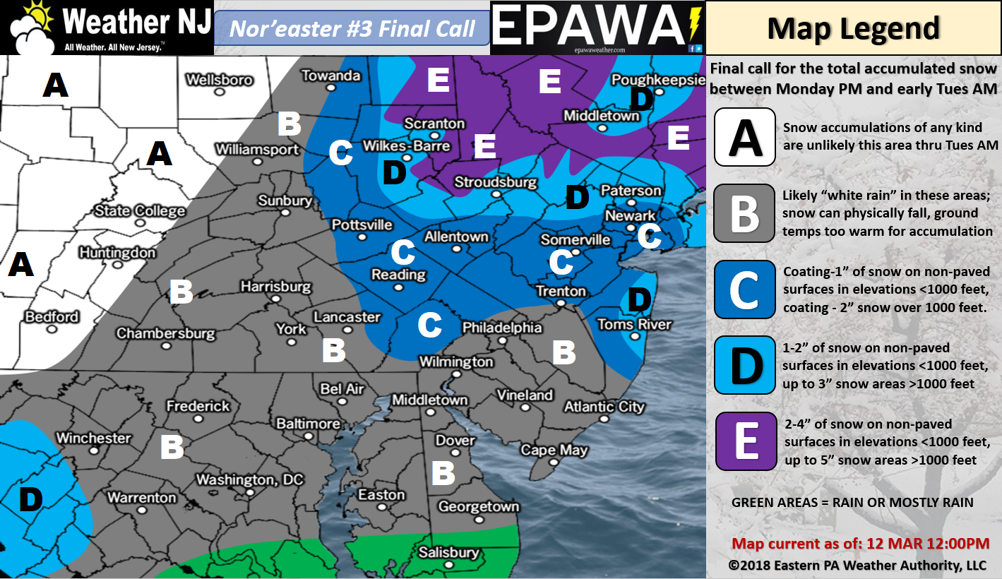
Please click here for full-resolution snow map!
Discussion: The primary coastal surface low has formed off South Carolina. It should track just off OBX today and then just to the SE of the 40N/70W benchmark by Tuesday morning. At 500mb, the northern upper-level low is diving into the Great lakes area from Canada. The southern shortwave was closed for a bit this morning but is now back open as it begins to interact with the Great Lakes upper-level low. These two upper-level players will form a trough that tilts negatively. This should bring the primary coastal surface low close enough to produce an E New England blizzard…but not close enough for the Mid-Atlantic US states. Instead, the Mid-Atlantic US states (especially New Jersey) should be subject to only fringe impacts from the very powerful (likely sub-970mb) low.
The best chance for snow exists in two areas moreso than the rest of NJ. First are the NNJ elevations. This area is subject to upper-level low enhancement/interaction type precipitation. Due to the higher elevations (with below-freezing surface) there is a better chance for stickage up there. The other area runs from Ocean County through Monmouth County and includes the general NJ counties that surround NYC. This area is subject to the infant snow bands that will later crush E New England. If these snow bands can produce heavy-enough snowfall to cool down the 35-38F surface then slushy accumulations should ensue. Otherwise light snowfall is not going to cut it. Light snowfall would simply melt on contact or what we call “white rain.” The rest of SNJ, especially SWNJ, are favored for the least-wintry outcome. Anyone SE of I-95 is subject to starting as rain before changing over to snow. For these reasons, we’ve made our map above.
As far as winds go, I think the coast should see the greatest impact. Areas along the immediate ENJ coast could see sustained winds of 15-25mph with gusts to 35mph at times. I wouldn’t rule out a gust that takes a run at 40mph, especially with a sub-970mb low so close by. Areas away from the ocean will likely see lesser wind values.
Coastal flooding should be held to the minor stage with the highest tide occurring tonight. Tomorrow’s next two high tides could then reach near-minor criteria before dropping back to normal range by Wednesday. Minor beach erosion is also expected between tonight and Wednesday AM.
In English: This is E New England’s snow storm, not New Jersey’s. New Jersey is still subject to fringe impacts including light snow accumulations (see above map), moderate winds and minor coastal flooding. Therefore we’re getting grazed by an approaching winter storm. This should bring some relief to areas just-impacted by the prior two nor’easters. With this general setup, impacts could have been much larger. Live-casting begins now as precipitation is approaching from the S/SW. I expect precipitation to spread into NJ later today/this evening as winds pick up. Areas SE of I-95 could start as rain before changing over to snow. Peak snowfall should occur between 11PM and 5AM as winds crank. Precipitation should taper off from W/SW to E/NE by mid-to-late Tuesday morning. Breezy/gusty winds should remain through the rest of the week rocking in-direction from NW to W. I’ll try to squeeze in a detailed Tuesday-Friday outlook later tonight to get us to the weekend. I’m monitoring a storm signal in the March 20-21 window but it’s too soon to talk precip-types and amounts. Let’s get this system out of here first and see if the March 20-21 signal drops off. Have a great day and please be safe! JC
For comprehensive and interactive hyper-local analysis that goes way above and beyond the detail of this public forecast, check out our premium services which include early hyper-local text notifications and guaranteed individual forum interaction. A must for outdoor businesses that depend on the best real-time data possible.
Jonathan Carr (JC) is the founder and sole operator of Weather NJ, New Jersey’s largest independent weather reporting agency. Since 2010, Jonathan has provided weather safety discussion and forecasting services for New Jersey and surrounding areas through the web and social media. Originally branded as Severe NJ Weather (before 2014), Weather NJ is proud to bring you accurate and responsible forecast discussion ahead of high-stakes weather scenarios that impact this great garden state of ours. All Weather. All New Jersey.™ Be safe! JC


LOCAL FORECAST | INTERACTIVE RADAR | LATEST NJ WEATHER ALERTS | WEDDING FORECAST| PRIVACY POLICY
© Copyright 2026 Weather NJ LLC. All Rights Reserved.
Some information that can be found on our website is provided by a private weather station and is not an officially recognized station for weather reporting. Though we always strive to achieve accurate reporting for our own use, it is important that you do NOT depend on the data provided here for any purpose.
