

March 17: Snow Storm Update
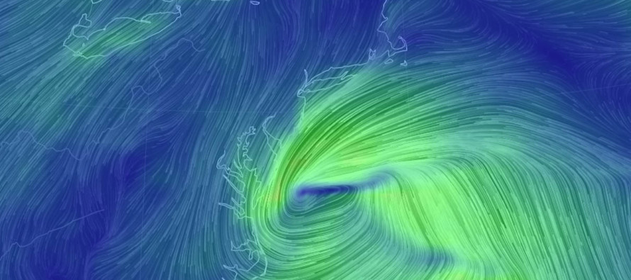
Discussion: The models are still all over the place with regard to surface output. The upper-levels are starting to make a little more sense however. It looks like we’ll see a brief +PNA spike fed by an Alaskan upper-level low induced -EPO. This should allow the trough to form downstream for the E US. The upper-level energy from the Monday-Tuesday storm is still hanging around E Canada. You can see on current live observations that it really has nowhere to go due to the block even further N/NE in the Atlantic. Therefore the back side of this E Canadian upper-level circulation could act as a pseudo-block for the approaching Pacific shortwave (our ~Tuesday-Wednesday storm of interest)—keeping it further to the S.
Most ensemble spreads have focused expected track to the S of New Jersey. Therefore I’d say the chances for New Jersey snowfall are increasing. We simply cannot call the jackpot within New Jersey yet. I’m not blown away by the accumulation potential either. If most precipitation were to fall during daylight hours on Tuesday, accumulations could struggle big time. It would have to puke snow during the day. Precipitation would have to fall at least moderately during the early AM hours of Tuesday or after sunset Tuesday PM to reasonably expect stickage S of I-78. Light snowfall would likely not cut it with expected snow ratios < 10:1. Those N of I-78 would likely accumulate easier…IF precipitation makes it that far N from the south-sliding system. Therefore lot more snow could fall than would actually stick, especially on paved surfaces. Slushy roads can still present hazardous travel conditions however so the threat still needs to be taken seriously.
By tomorrow’s completion of the 12z model suite we should have a much better handle on expected surface conditions. We’re just not there yet on specific precipitation types and amounts. At this point confidence is only moderate-to-high for a period of wind, possible coastal flooding/beach erosion, and some form of precipitation in that ~Tuesday-Wednesday period
In English: Serious tracking mode has begun for the ~Tuesday-Wednesday winter storm potential. Today’s analysis suggests an increased chance of such happening. Two days ago this was an east coast winter storm. today it has been narrowed to a coastal Mid-Atlantic US winter storm including New Jersey. Wintry impact potential currently ranges from significant-to-major. The first call public snow map will be released tomorrow which will include precipitation types, expected snow accumulations, specific location and timing.
For year-round comprehensive and interactive analysis, including run-by-run model analysis, that goes way above and beyond the detail of this public forecast, check out our premium services which include early hyper-local text notifications and guaranteed individual forum interaction. A must for outdoor businesses or the most extreme passionate weather enthusiast who depends on the best real-time data possible.
Jonathan Carr (JC) is the founder and sole operator of Weather NJ, New Jersey’s largest independent weather reporting agency. Since 2010, Jonathan has provided weather safety discussion and forecasting services for New Jersey and surrounding areas through the web and social media. Originally branded as Severe NJ Weather (before 2014), Weather NJ is proud to bring you accurate and responsible forecast discussion ahead of high-stakes weather scenarios that impact this great garden state of ours. All Weather. All New Jersey.™ Be safe! JC


LOCAL FORECAST | INTERACTIVE RADAR | LATEST NJ WEATHER ALERTS | WEDDING FORECAST| PRIVACY POLICY
© Copyright 2026 Weather NJ LLC. All Rights Reserved.
Some information that can be found on our website is provided by a private weather station and is not an officially recognized station for weather reporting. Though we always strive to achieve accurate reporting for our own use, it is important that you do NOT depend on the data provided here for any purpose.
