

March 18: Snow Targeting New Jersey
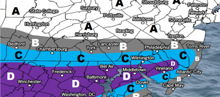
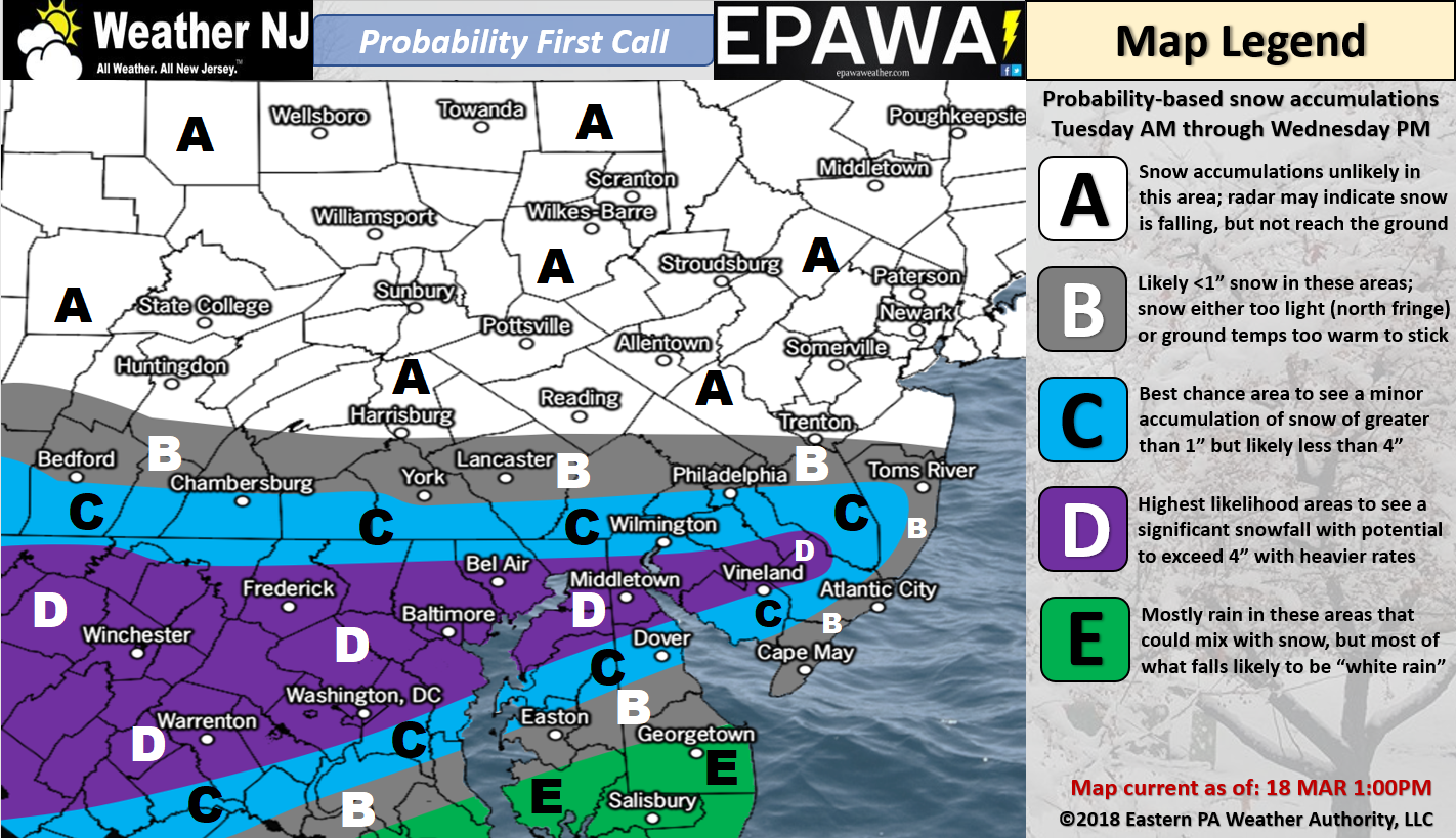
Please click here for full-resolution snow map!
Discussion: The Pacific shortwave involved should track across the US from W to E along ~38N between now and Tuesday morning. Some northern stream energy should then try and inject into the trough Tuesday into Wednesday which crafts our winter storm potential. As mentioned yesterday this is supported upstream by a +PNA and -EPO as well as a downstream psuedo-block from the backside of the departing upper-level low. At the surface model guidance is still back and forth over multiple waves vs a single consolidated low along the frontal boundary. We should have that more ironed-out for tomorrow’s final call.
What we do know is that model guidance continues to suggest a low passing to the S of NJ. Most guidance struggles to bring accumulating snow N of I-195 now. Recent runs of the Euro and NAM suggest a further N jackpot but we’re going to monitor that overnight. Wherever that northern cut-off falls, it should be sharp. This will be due to the expected confluence on the N side of the low. The dry air should shear anything apart that tries to form to the N of the NJ jackpot.
We know that 700mb will be cold enough for all of NJ to support snowmaking aloft. 850mb nudges the 0C line to about I-195. This could mean the surface will be above freezing as far N as I-78, especially during daytime hours. It’s another marginal surface environment for accumulating snowfall. Only under the heavier precipitation rates will snowfall want to accumulate…and mostly only during overnight snowfall. We don’t think light snowfall will allow accumulations, especially during the day.
This is a pretty flat wave overall but coastal ENJ is still subject to a period of gusty onshore flow. This could present minor-to-moderate coastal flooding and more beach erosion. ENJ would also carry the best chance for higher winds. I could see sustained winds of 15-25mph with gusts to 40mph for immediate coastal areas. Winds would likely relax as you get away from the ocean (W of the Garden State Parkway).
In English: The Southern 2/3 of New Jersey has become the current target of this snow event. Please see our map above for our first call on expected accumulations. We understand that more snow will fall than actually sticks. We’ve also factored in as many micro-climate influences as possible (marine, sun angle, etc.). For tomorrow’s final call we will make any north or south adjustments as needed. There’s still a lot of data to get through overnight and tomorrow (between now and then). A wintry mix is possible to start as early as Tuesday morning for relevant SNJ areas. As temperatures drop during Tuesday PM hours, snowfall is expected overnight which should wrap up by noon-ish Wednesday. Most snowfall that falls during the daytime on Tuesday should struggle to accumulate on paved surfaces, unless precipitation rates can puke. Overnight snowfall Tuesday into Wednesday morning has a better chance of stickage on paved surfaces but would likely produce wet slushy accumulations. Higher amounts would be possible on natural/cold surfaces. Otherwise more wind, coastal flooding and beach erosion is likely for ENJ in the Tuesday night to Wednesday night period. This storm will not be as powerful as the nor’easters as of late but it could still present hazardous travel conditions, especially for Wednesday AM commuting hours. Have a great rest of your Sunday and please be safe! JC
For year-round comprehensive and interactive analysis, including run-by-run model storm analysis, that goes way above and beyond the detail of this public forecast, check out our premium services which include early hyper-local text notifications and guaranteed individual forum interaction. A must for outdoor businesses or the most extreme passionate weather enthusiast who depends on the best real-time data possible.
Jonathan Carr (JC) is the founder and sole operator of Weather NJ, New Jersey’s largest independent weather reporting agency. Since 2010, Jonathan has provided weather safety discussion and forecasting services for New Jersey and surrounding areas through the web and social media. Originally branded as Severe NJ Weather (before 2014), Weather NJ is proud to bring you accurate and responsible forecast discussion ahead of high-stakes weather scenarios that impact this great garden state of ours. All Weather. All New Jersey.™ Be safe! JC


LOCAL FORECAST | INTERACTIVE RADAR | LATEST NJ WEATHER ALERTS | WEDDING FORECAST| PRIVACY POLICY
© Copyright 2026 Weather NJ LLC. All Rights Reserved.
Some information that can be found on our website is provided by a private weather station and is not an officially recognized station for weather reporting. Though we always strive to achieve accurate reporting for our own use, it is important that you do NOT depend on the data provided here for any purpose.
