

March 19: Winter Storm Update
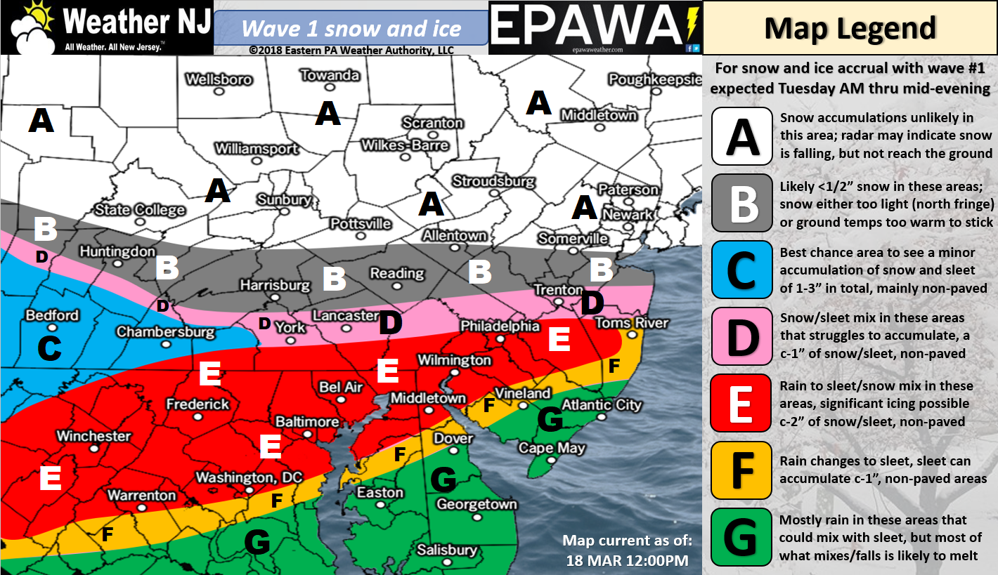
Please click here for full-resolution wave 1 snow map!
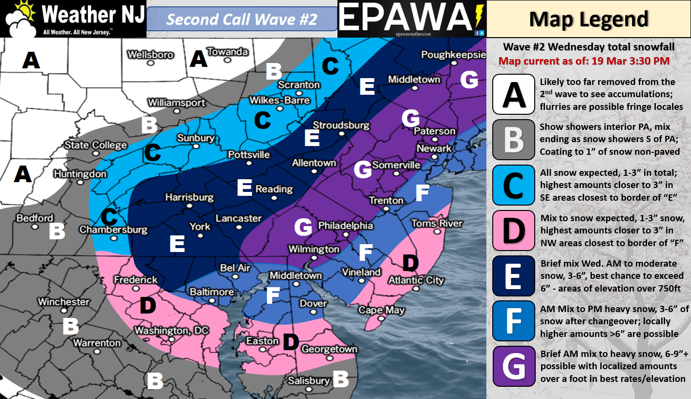
Please click here for full-resolution wave 2 snow map!
Discussion: The overall Tuesday-Wednesday event is now broken down into two individual waves. The first wave is mostly due to the Pacific shortwave that crosses the US from W to E in a very flat manner. Once it arrives near the Appalachian Mountains between 38N and 40N it will pull back and wait for a northern stream energy injection. At this point the weaker wave 1 comes through CNJ/SNJ between Tuesday morning and Tuesday night, producing a mixed bag of rain, snow and/or sleet. Then once the northern energy is injected, a broader and deeper trough should develop with a closed-off upper-level low off the coast of New Jersey. This is the wave that has a chance to produce moderate-to-heavy wet snowfall from late-Tuesday night through most of Wednesday. Precipitation could taper off as early as Wednesday evening or as late as early-Thursday morning. It’s very easy to see that a lot of snow is expected to fall out of the sky from the second wave. No one is debating that.
The surface accumulation issues arise from several factors. First, the heaviest snowfall on Wednesday looks to happen during daylight hours. Late-season sun-angle could knock accumulations down some. Second, this should be a very heavy wet snowfall which compacts tightly on the ground due to additional weight. Third, accumulations are much more likely to stack up higher on cold/natural surfaces than on roads. All of this would be more of an issue for SENJ and less of an issue for I-95/NWNJ. Mesoscale dynamics can always coectively enhance snowfall locally but that’s more of a wildcard at this point. It simply cannot be counted on for snow map-making purposes. With all of that said our above snow maps represent our comprehensive thoughts about the two waves.
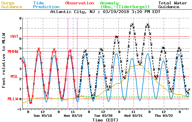
High winds and coastal flooding are likely with this overall event, especially on Wednesday when the second wave low passes closely to the SE of SNJ. Areas away from the ocean should experience run-of-mill storm winds. Areas along the ENJ coast should see higher winds with gusts to 40mph, or slightly greater, possible. This presents a wind-driven storm surge threat to barrier islands and back bays. The highest water levels should surround two high tides…just before midnight Tuesday night and just before noon on Wednesday. Minor-to-moderate coastal flooding is possible. For example, here’s the expected tidal guidance for Atlantic City which should be in the same ball park from Sandy Hook down through Cape May. Blue = astronomical tide. Gold = storm surge. Black = astronomical tide + storm surge which = total expected storm tide.
IMO, the most significant threat is heavy wet snow and high winds taking down tree branches, power lines, and producing widespread power outages. Coastal flooding is also a higher concern. As far as snowfall accumulations on their own, we’ve seen bigger snow storms and roads should see less accumulations than natural surfaces. You should still anticipate plowable/slushy road accumulations however which can produce hazardous travel conditions. Our final call will be issued tomorrow and will mostly contain any final needed tweaks for the second wave. The first wave is fairly straightforward at this point.
In English: Wednesday seems like the higher impact day than Tuesday. Tuesday (wave 1) should feature a wintry mix confined to CNJ and SNJ with minimal (but some) road worries. Wednesday (wave 2) should feature the heavier snow thump after changing over from the wintry mix to mostly snow (please see above maps for expected accumulations from each individual wave). Snowfall should be heavy and wet on Wednesday. Coupled with high winds and you have a widespread power outage recipe again. Coastal flooding is expected to range from minor-to-moderate criteria from Tuesday night through Wednesday night. Our final call tomorrow will feature any necessary tweaks for the second wave on Wednesday (the snowier wave). Have a great night and please be safe! JC
For year-round comprehensive and interanvctive analysis, including run-by-run model storm analysis, that goes way above and beyond the detail of this public forecast, check out our premium services which include early hyper-local text notifications and guaranteed individual forum interaction. A must for outdoor businesses or the most extreme passionate weather enthusiast who depends on the best real-time data possible.
Jonathan Carr (JC) is the founder and sole operator of Weather NJ, New Jersey’s largest independent weather reporting agency. Since 2010, Jonathan has provided weather safety discussion and forecasting services for New Jersey and surrounding areas through the web and social media. Originally branded as Severe NJ Weather (before 2014), Weather NJ is proud to bring you accurate and responsible forecast discussion ahead of high-stakes weather scenarios that impact this great garden state of ours. All Weather. All New Jersey.™ Be safe! JC


LOCAL FORECAST | INTERACTIVE RADAR | LATEST NJ WEATHER ALERTS | WEDDING FORECAST| PRIVACY POLICY
© Copyright 2026 Weather NJ LLC. All Rights Reserved.
Some information that can be found on our website is provided by a private weather station and is not an officially recognized station for weather reporting. Though we always strive to achieve accurate reporting for our own use, it is important that you do NOT depend on the data provided here for any purpose.
