March 2: Nor’easter Update

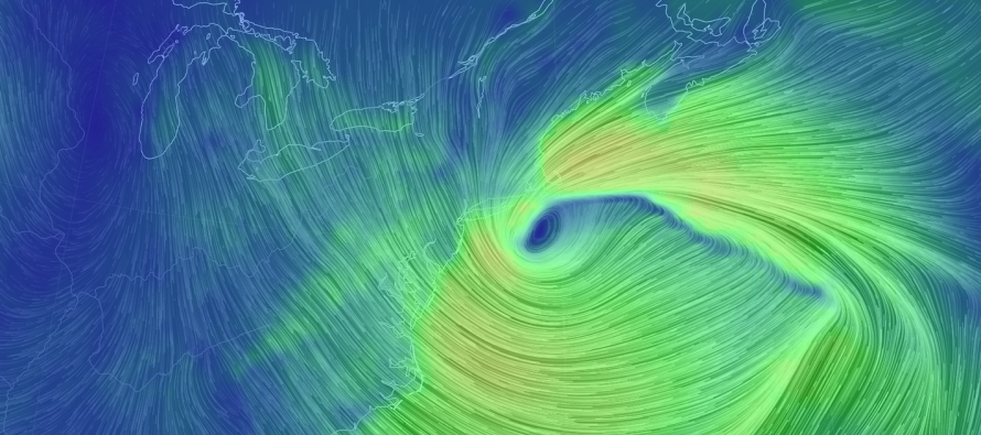
Discussion: The nor’easter has intensified to a 974mb low just S of Cape Cod. It is now taking small steps towards the NJ coast while ultimately moving S and away away to the S/SE towards Bermuda. Let’s take each weather condition at a time…
Precipitation: The latest short-range guidance and observations indicate that precipitation should taper off by midnight tonight with remnants into the early AM hours of Sunday. Most of New Jersey is now all snow. With temperatures dropping from loss of daylight as well as continued heavier precipitation rates, there’s a good chance for additional statewide accumulations before precipitation ends. How much more could fall? Perhaps another few inches on top of what you have right now. Extreme SENJ is most-favored to inhibit accumulations due to marine influence. The elevations of NNJ have Kaboomed.
Wind: Peak wind gusts from this system should continue into overnight hours. They should start to subside tomorrow and gradually diminish through the rest of the weekend. I’ve seen clocked values of 50-60mph in the LBI to Cape May area.
Coastal Flooding: The greatest risk for coastal flooding is still expected for tonight through Saturday and possibly into Sunday. Today were just the lead-up tides. As the low drifts further S, the more we are exposed to onshore water flow. That is the main reason for higher tides tomorrow (after precipitation has ended).
In English: Snow could accumulate another couple of inches before ending by midnight. Winds should remain strong overnight and begin lessening tomorrow morning. Moderate-to-major coastal flooding for the entire Jersey coast is still possible from tonight through Sunday. Be safe! JC
For comprehensive and interactive hyper-local analysis that goes way above and beyond the detail of this public forecast, check out our premium services which include hyper-local text notifications from and guaranteed forum discussion with myself and Eastern PA Weather Authority (EPAWA).
Jonathan Carr (JC) is the founder and sole operator of Weather NJ, New Jersey’s largest independent weather reporting agency. Since 2010, Jonathan has provided weather safety discussion and forecasting services for New Jersey and surrounding areas through the web and social media. Originally branded as Severe NJ Weather (before 2014), Weather NJ is proud to bring you accurate and responsible forecast discussion ahead of high-stakes weather scenarios that impact this great garden state of ours. All Weather. All New Jersey.™ Be safe! JC


