

March 20: Final Call Snow Map

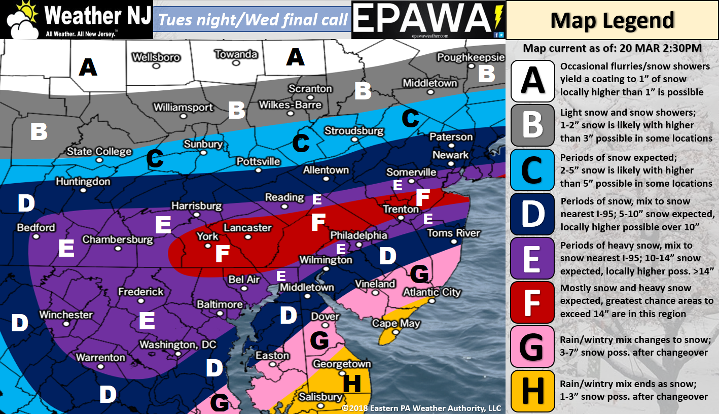
Please click here for full-resolution snow map!
Discussion: I want to start off saying that this forecast has high bust potential in either direction. Model guidance and live observations have been ridiculously tricky to get a hold of even now, less than 24 hours before the meat and potatoes of the snowfall. With that said, the above snow map represents our best evidence-based call we can possibly give, taking all things into consideration including sleet, solar radiation and onshore marine influence (things the models do not see).
Our leading Pacific shortwave has opened up near the Ohio Valley and will now fall back into the northern stream energy injection. This allows the first wave (today) to come through before the upper-level trough develops with another closed-off upper-level low just E of New Jersey. That second ULL should explode the secondary coastal low into our snow storm (tomorrow). Given the convective dynamics possible, thundersnow and thundersleet are very possible, especially when the atmosphere rapidly cools tomorrow morning/afternoon.
The rest of tonight will continue to produce on-and-off precipitation of various types (rain, sleet and snow). There’s currently a mean mesoband running across S/C NJ but that should lift northward soon. SNJ is favored the warmest and NNJ is favored the coldest. Light accumulations are possible into tonight but not like what is expected tomorrow. The true hazardous snowy impacts of this system begin by late-morning tomorrow and last through tomorrow night.
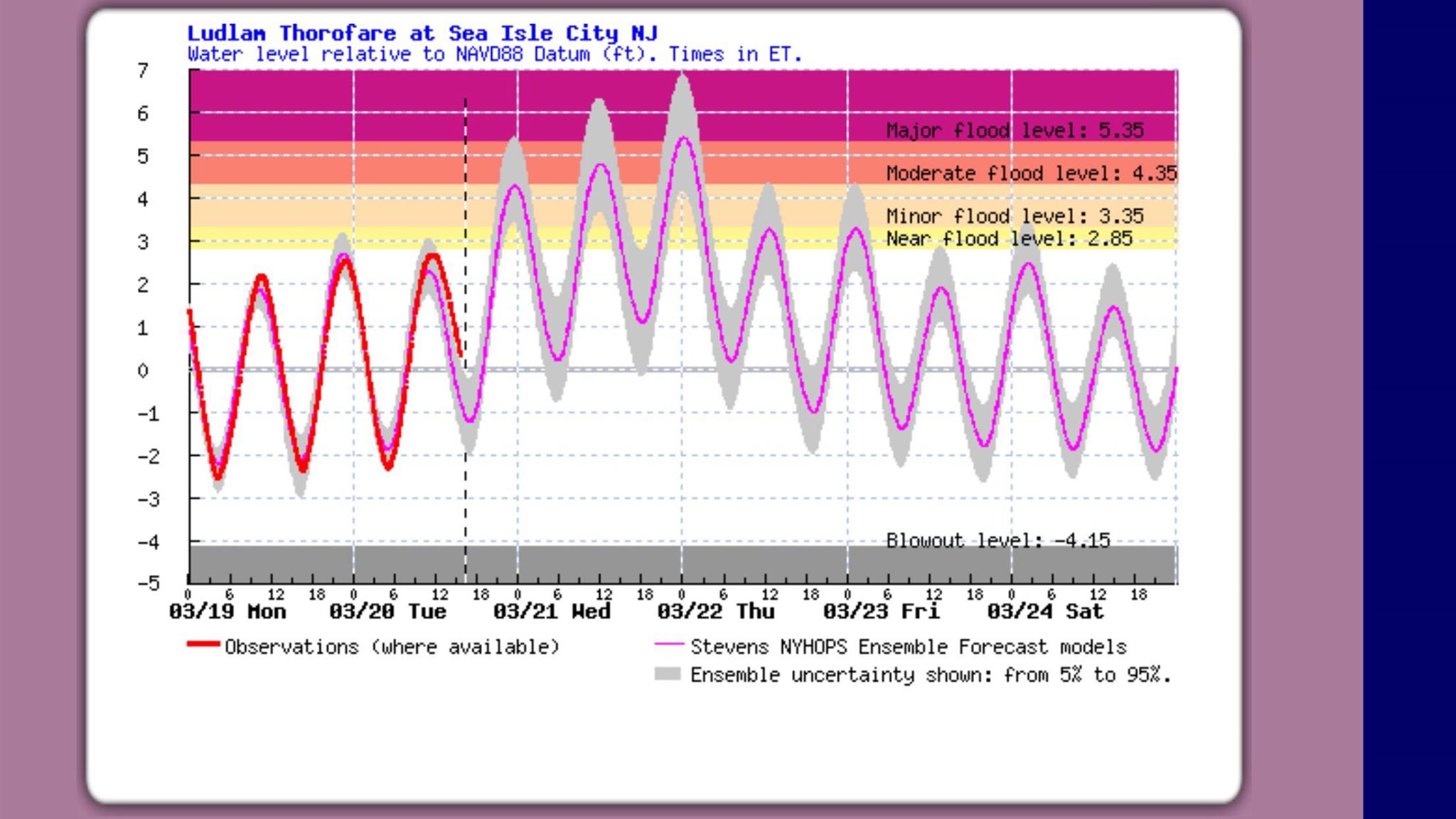
Winds and coastal flooding should increase by tonight. Immediate ENJ coastal areas should expect the highest winds and obviously the worst of the coastal flooding. For this area, sustained winds of 15-25mph with gusts to 40-45mph are possible. Areas away from the coast should see lesser wind values but still noticeable and still enough to contribute to statewide widespread power outages. Tonight’s high tide, and the next 3-4 high tides through Thursday, should have no problem reaching minor levels of coastal flooding. The question is whether or not coastal flooding will reach moderate or major levels. This depends on how close the coastal surface low can tuck into the Delmarva/SENJ coast. Some models retrograde the low (very bad = major coastal flooding possible) and other models just stall it a bit before the low resumes eastward progression (not as bad – coastal flooding likely held to moderate). Unfortunately tidal guidance, like this Sea Isle, NJ output from Stevens University, is very open to the possibility of major coastal flooding:
With all of this said, it’s now time to monitor live observations and ultra-short range model guidance and adjust in live-casting for any curveballs or wrenches thrown into the mix.
In English: A wintry mix should persist from now through overnight hours and into tomorrow morning. There’s a pretty gnarly snow band across CNJ/SNJ right now (accumulating on paved surfaces) but that will lift northward into CNJ, maybe NNJ, in the next hour or two and most SNJ areas should go back to a mix overnight. Light wintry accumulation is possible for all areas otherwise tonight. A lull in precipitation is possible during core overnight hours. By noon-ish tomorrow (possibly by as early as mid-to-late morning), rain/sleet should change to all snow for CNJ/SNJ (NNJ stays mostly snow). A heavy wet thump of snow is then expected statewide tomorrow from the changeover until ~late-evening. Our above snow map is how much we think will fall and accumulate by the end of that time-frame. Paved surfaces could see lesser values than natural/cold surfaces. I honestly could care less if we see 8 or 16 inches of snow. Either way we’re likely in for a mess and it’s not the accumulation totals that will headline the required safety awareness for this event. It’s the heavy wet factor of the snow coupled with gusty winds that worries me about statewide power outage potential and falling trees/branches/power lines/etc. It’s the coastal flooding for ENJ, especially SENJ, that worries me. I know you all love snow but we focus on safety awareness here first and foremost. Charge up your mobile devices and gas up your vehicles now because who knows how many will be without power and/or connectivity during/after this system. Lastly, for the weather enthusiasts out there, thundersnow and thundersleet are possible tomorrow when temps drop and the heavy snow begins. Everyone have a great night and please be safe! KABOOM -JC
For year-round comprehensive and interactive analysis, including run-by-run model storm analysis, that goes way above and beyond the detail of this public forecast, check out our premium services which include early hyper-local text notifications and guaranteed individual forum interaction. A must for outdoor businesses or the most extreme passionate weather enthusiast who depends on the best real-time data possible.
Jonathan Carr (JC) is the founder and sole operator of Weather NJ, New Jersey’s largest independent weather reporting agency. Since 2010, Jonathan has provided weather safety discussion and forecasting services for New Jersey and surrounding areas through the web and social media. Originally branded as Severe NJ Weather (before 2014), Weather NJ is proud to bring you accurate and responsible forecast discussion ahead of high-stakes weather scenarios that impact this great garden state of ours. All Weather. All New Jersey.™ Be safe! JC


LOCAL FORECAST | INTERACTIVE RADAR | LATEST NJ WEATHER ALERTS | WEDDING FORECAST| PRIVACY POLICY
© Copyright 2026 Weather NJ LLC. All Rights Reserved.
Some information that can be found on our website is provided by a private weather station and is not an officially recognized station for weather reporting. Though we always strive to achieve accurate reporting for our own use, it is important that you do NOT depend on the data provided here for any purpose.
