

March 21: Evening Winter Storm Update
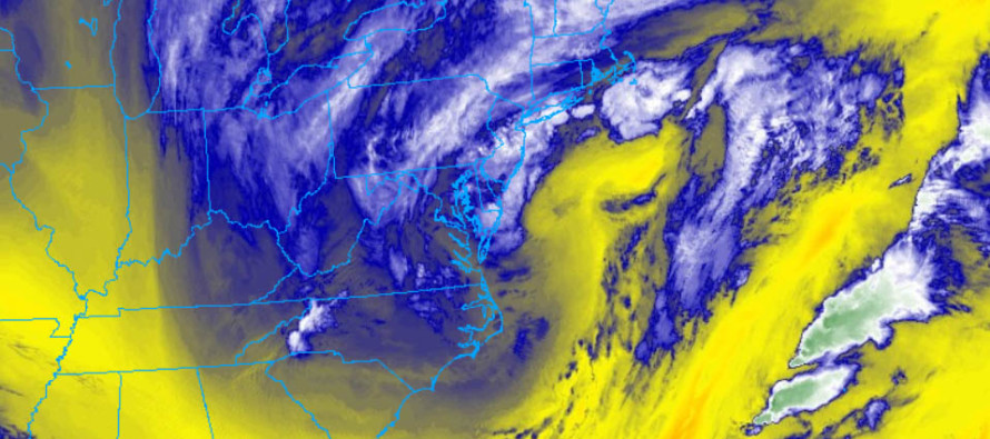
Discussion: It appears EPA and NWNJ will be first to taper off over the hours. EPA saw expected totals today but NWNJ did not mostly due to confluence/drier air. NENJ might hang on another hour or two beyond simply because of the snow bands coming off the ocean into points further S. But more than likely NENJ will end lower than expected. Much of CNJ (near the I-95 corridor) is currently under steady snowfall with 6 inches+ on the ground now. Still a few hours left for CNJ which might take us past midnight, especially Monmouth County. Parts of CNJ still have a chance to hop into the 10-14 zone we had called for. SWNJ saw much of it’s snowfall earlier today and is mostly winding down. Still a small chance of remnant snow bands reaching back into SWNJ but nothing significant. SENJ has seen a ridiculous thumping in the last 3 hours and moderate-to-heavy snowfall continues. This snowfall has crept up the coast into Monmouth County and is helping to feed the CNJ band.
I told you all in my final call that I didn’t care whether 6 or 16 inches fell. The true hazard begins now as heavy wet snow weighs down tree branches and power lines. Winds are now gusting out of the N. Not too bad but it doesn’t take much to help sway branches and lines. There are already numerous power outage reports on social media. Trees are going to be cracking/splitting and there’s a good chance of a few transformers popping. If you still have power, I would charge up your mobile devices especially if you have more than 6 inches of snowfall from today.
We’ll be approaching the another high tide around midnight. Minor-to-moderate coastal flooding is possible with this tide as well as tomorrow’s high tide near noon. After that tidal waters should subside along the ENJ coast.
In English: Snow should begin wrapping up from W to E across New Jersey over the next 3-6 hours. Areas tapering will continue to taper. Areas puking will continue to puke during this time. Coastal Monmouth and Ocean should be last to end during early Thursday AM hours. Colder NW winds are expected tomorrow. The winds combined with heavy wet snow laying on tree branches and power lines likely means power outages overnight and tomorrow. Have a great night and be safe! JC
For year-round comprehensive and interactive analysis, including run-by-run model storm analysis, that goes way above and beyond the detail of this public forecast, check out our premium services which include early hyper-local text notifications and guaranteed individual forum interaction. A must for outdoor businesses or the most extreme passionate weather enthusiast who depends on the best real-time data possible.
Jonathan Carr (JC) is the founder and sole operator of Weather NJ, New Jersey’s largest independent weather reporting agency. Since 2010, Jonathan has provided weather safety discussion and forecasting services for New Jersey and surrounding areas through the web and social media. Originally branded as Severe NJ Weather (before 2014), Weather NJ is proud to bring you accurate and responsible forecast discussion ahead of high-stakes weather scenarios that impact this great garden state of ours. All Weather. All New Jersey.™ Be safe! JC


LOCAL FORECAST | INTERACTIVE RADAR | LATEST NJ WEATHER ALERTS | WEDDING FORECAST| PRIVACY POLICY
© Copyright 2026 Weather NJ LLC. All Rights Reserved.
Some information that can be found on our website is provided by a private weather station and is not an officially recognized station for weather reporting. Though we always strive to achieve accurate reporting for our own use, it is important that you do NOT depend on the data provided here for any purpose.
