

March 31: Monday Morning Snow Map
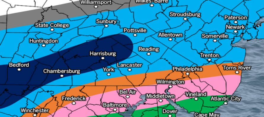
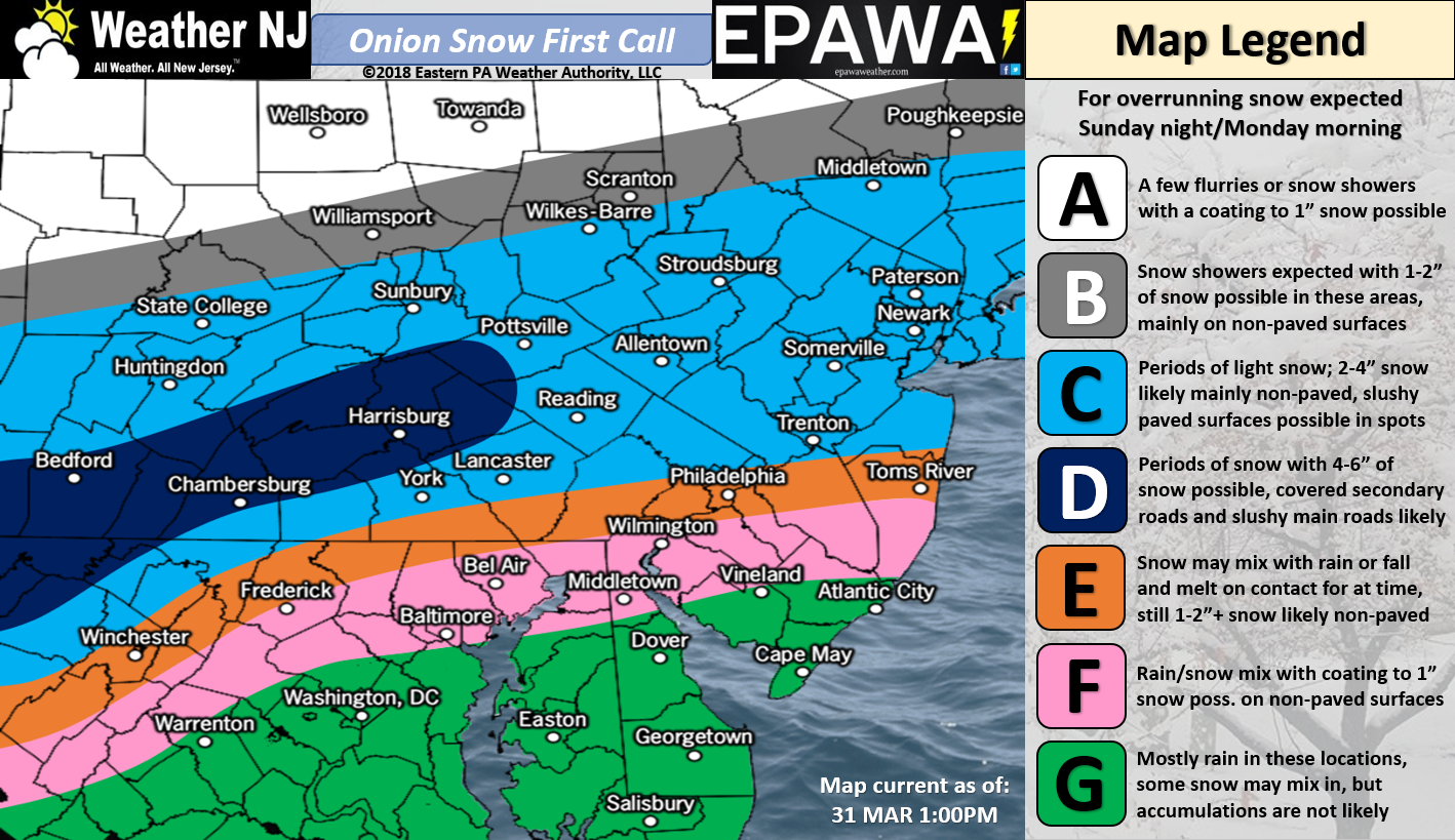
Click here to view full-resolution snow map!
Discussion: I’d love for this to be an April fools joke but it’s not. Personally, I feel this snow event is in bad taste. It’s a beautiful sunny early-spring day and I’m inside working on a snow forecast. Like many of you, I believe wintry weather has it’s place which is not now. Personal feelings aside, there exists travel hazards associated with this event and therefore safety awareness needs to be aggregated.
Model guidance is indicating a very weak shortwave passing overhead at the 500mb level. The expected surface low pressure is around ~1012mb. These are weak numbers for a snow storm. I do see some impressive 700mb vertical velocity and 850mb frontogenesis expectations however. Therefore I guess we have to take the probability of a weak snow event seriously.
It’s a quick mover but it’s well-timed during the coldest overnight hours. Daytime Sunday is looking fairly mild just ahead of this but temperatures are expected to fall behind the dry frontal passage Sunday evening…just cold enough for the upper levels to produce wintry precipitation.
Let’s break NJ into 3 parts: NNJ (N of I-78), CNJ (between I-78 and I-195) and SNJ (S of I-195). I know that’s not a straight geographic trisection but the highways make it easier to follow:
- NNJ: Coldest temperatures with periods of light-to-moderate snowfall. The elevations have the best chance for a few inches of road accumulation. Lower elevations of NNJ will likely see accumulations on natural/cold surfaces only with maybe a trace/slushy buildup on side roads. Treated main roadways should be just wet below 1000 ft of elevation.
- CNJ: Warmer temperatures with periods of moderate-to-heavy snowfall. Cold/natural surfaces should do much better than paved surfaces. Most roads should range from just being wet to trace/slush buildup.
- SNJ: Warmest temperatures with periods of mixed precipitation. This area has the least chance for paved accumulations. Most snowfall should be conversational white rain with maybe a little non-paved accumulation. N Ocean and N Burlington could behave more like CNJ. For places like Cape May, it can snow as hard as it wants. I just don’t see anything stacking.
So while NNJ will see the coldest temperatures, they will see lighter precipitation on the northern fringe of the system. CNJ will see heavier precipitation but with temperatures not as cold. Therefore the entire area C on our above snow map should finish somewhat similar. I’m not too worried about areas E, F and G as far as road accumulations go. Please use all the caution you normally would for wet/slippery roads and surfaces however. Heavy traffic and accidents will likely occur during the Monday AM rush hour.
In English: A nuisance snow event is expected between late Sunday night and Monday morning. It’s a quick mover but it’s timed perfectly with the coldest part of the night. This snow event should accumulate more easily on natural/cold surfaces than roads. There should be a lot of “white rain” hitting the streets, especially S of I-78. NNJ is the only part of NJ where I think snow could stack up to a mildly disruptive level, especially in NNJ elevations. Our above snow map represents our first call thoughts. We’ll likely release a final call tomorrow. Everyone have a great rest of your Saturday and please be safe! JC
For comprehensive and interactive hyper-local analysis that goes way above and beyond the detail of this public forecast, check out our premium services which include early hyper-local text notifications and guaranteed individual forum interaction. A must for outdoor businesses that depend on the best real-time data possible.
Jonathan Carr (JC) is the founder and sole operator of Weather NJ, New Jersey’s largest independent weather reporting agency. Since 2010, Jonathan has provided weather safety discussion and forecasting services for New Jersey and surrounding areas through the web and social media. Originally branded as Severe NJ Weather (before 2014), Weather NJ is proud to bring you accurate and responsible forecast discussion ahead of high-stakes weather scenarios that impact this great garden state of ours. All Weather. All New Jersey.™ Be safe! JC


LOCAL FORECAST | INTERACTIVE RADAR | LATEST NJ WEATHER ALERTS | WEDDING FORECAST| PRIVACY POLICY
© Copyright 2026 Weather NJ LLC. All Rights Reserved.
Some information that can be found on our website is provided by a private weather station and is not an officially recognized station for weather reporting. Though we always strive to achieve accurate reporting for our own use, it is important that you do NOT depend on the data provided here for any purpose.
