

March 6: Final Call Snow Map
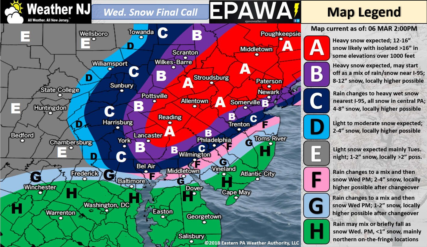
Click here for full-resolution snow map!
Click here for full-resolution snow map!
Discussion: These late-winter storms are tricky. Let’s get the more confident areas out of the way first. Areas to the NW of I-95 are most likely to KABOOM (zones A and possibly B), especially NWNJ. SENJ (the green area labeled H on the map) should see mostly rain (up to an inch) that possibly ends with light slushy accumulations. These light slushy SENJ accumulations are likely non-issues for places like LBI, Brigantine, AC and Cape May. They could be more of an issue however the further you get away from the coast (towards I-95). SENJ will be battling a lot of physics that inhibit paved-surface accumulations.
The most difficult part of this forecast remains the I-95 corridor through NJ and immediate area SE of such (basically zones C, F, G and the NW part of H on the above map). This area has HUGE bust potential in either direction. What we have on the above map is a mean of many possibilities ranging from little-to-no accumulation to possibly 3 times the expected accumulations indicated…for these zones. Therefore we want the public to be absolutely clear that this area is uncertain. I indicated this area on yesterday’s first call and I have no gut-feeling changes about it. Only real-time live-observations tomorrow will be able to iron out this area. For now, this is the area most likely to KABUST in either direction. Let’s talk about some of the dynamics that support our call…
The low is currently on it’s way from the S Great Lakes area. Around midnight tonight, it should jump to the coast near the coastal VA/NC border. It should then rapidly develop and track up the coast tomorrow into tomorrow night. Part of the tremendous SNJ uncertainty is exact track. Closer to NJ coast = warmer solution for most of SNJ. Further from the coast = colder solution for SNJ.
Let’s talk temperatures. The surface for most of NJ will likely be at or just above freezing for this event. Only NWNJ is likely to see surface temperatures stay below-freezing for the entirety of the event. Aloft however we have very cold air in the 850-700mb layer. Therefore if precipitation rates are heavy enough, it will bring the colder air down to the surface. On the contrary, if precipitation rates are lighter, it will not be enough to cool the surface, especially with the heaviest precipitation expected to fall during peak daylight warming hours (higher sun angle t00). If you are wanting to see the snowier outcome tomorrow then the phrase you will want to see is “high rates of frontogenesis.” Frotongenesis returns highlight the best lifting and therefore the best precipitation rate areas. Thundersnow and even severe weather is actually possible under the heaviest precipitation bands wherever they form.
Coastal flooding should be held to the low-end of moderate and likely only minor. We have a period of onshore flow expected between Wednesday AM and Wednesday afternoon. This should provide some surge but not enough to overcome the lower astronomical tides….meaning, not enough to take us above the moderate risk. But heck, many are still seeing water in the streets during high tide, even today. This is from the rear-firing swell associated with the departing beast that hit us on Friday. Again though, I don’t think major coastal flooding is on the table. Just minor to low-end of moderate.
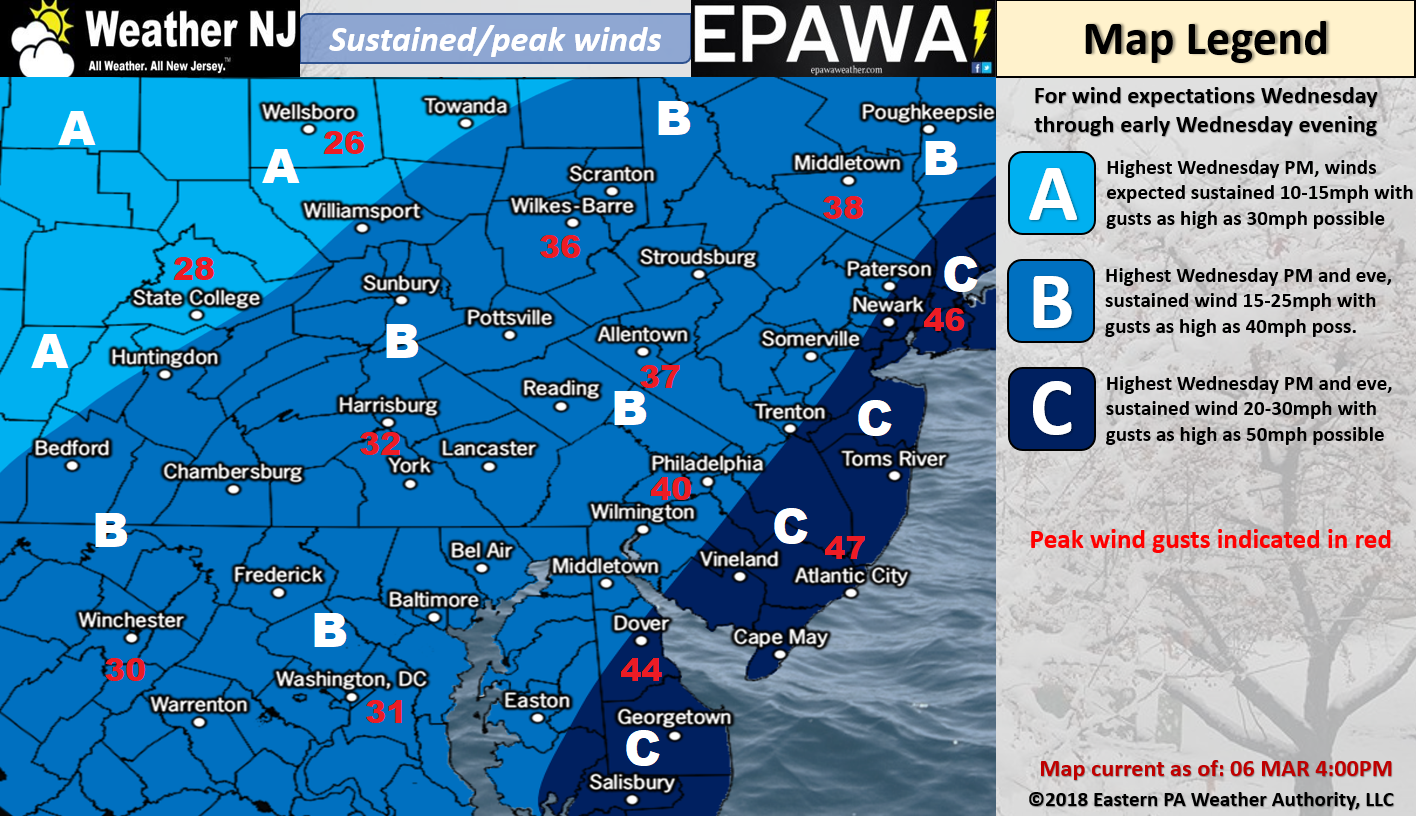
Winds should be most felt along the coast with gusts to 50mph+ possible. Areas away from the coast should see lesser wind gusts. The same goes for sustained winds…higher along coast than inland. Wind direction should cyclonically rock from SE to E to NE to N to NW as the low approaches and passes the Jersey coast. See our wind map above for a more detailed wind expectation.
I doubt our map is 100% accurate for anyone but it should give you an idea of what to expect. There are simply too many dynamics involved in this forecast. Therefore a lot of now-casting should be involved as we step through this system between late tonight and early Thursday, with Wednesday seeing the highest impacts statewide.
In English: NNJ should Kaboom, especially NWNJ. CNJ and SNJ are tricky and will have to be now-casted. Our map above represents our expected totals but strong caveats are needed for CNJ and SNJ because this area could bust big time in either direction (warmer and rainier or colder and snowier). Keep an eye and/or ear out for thundersnow as it is very possible under the heaviest precipitation bands. High winds are expected off the ocean tomorrow (see above wind map) which could pose a minor to low-end of moderate risk of coastal flooding along ENJ. The highest tide should be Wednesday morning with tides taking substantial decreases starting Wednesday night-forward as winds become more NW. Timing is event component based. Precipitation could start as early as late-tonight but certainly by early Wednesday AM. It will be moving in from the W/SW for those who wish to follow on radar. Precipitation should then remain steady through Wednesday morning and afternoon and then taper off by late-Wednesday evening from SW to NE. The snow/rain line should stay near the I-95 corridor for most of this event. It should only be towards the mid-to-end of this event that the snow/rain line crashes through the rest of SNJ. I’m going to try and put a video out later tonight to see where we stand as precipitation approaches. Have a great rest of your Tuesday and please be safe! JC
For comprehensive and interactive hyper-local analysis that goes way above and beyond the detail of this public forecast, check out our premium services which include early hyper-local text notifications from and guaranteed individual forum interaction.
Jonathan Carr (JC) is the founder and sole operator of Weather NJ, New Jersey’s largest independent weather reporting agency. Since 2010, Jonathan has provided weather safety discussion and forecasting services for New Jersey and surrounding areas through the web and social media. Originally branded as Severe NJ Weather (before 2014), Weather NJ is proud to bring you accurate and responsible forecast discussion ahead of high-stakes weather scenarios that impact this great garden state of ours. All Weather. All New Jersey.™ Be safe! JC


LOCAL FORECAST | INTERACTIVE RADAR | LATEST NJ WEATHER ALERTS | WEDDING FORECAST| PRIVACY POLICY
© Copyright 2026 Weather NJ LLC. All Rights Reserved.
Some information that can be found on our website is provided by a private weather station and is not an officially recognized station for weather reporting. Though we always strive to achieve accurate reporting for our own use, it is important that you do NOT depend on the data provided here for any purpose.
