

March 7: AM Winter Storm Observations
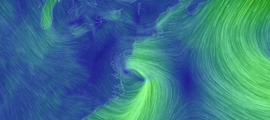
Discussion: The storm center is now intensifying just off the Delmarva Peninsula. It should take a run towards the Cape May-Atlantic City area before pulling away from the coast a bit. The low is not expected to sit on the coast like yesterday’s guidance suggested. This should produce a snowier solution for many in NJ as I indicated in last night’s video.
Right now the snow/rain line has pushed far into NJ from the SE, mainly because of the strong onshore flow. This was always expected to happen this morning. Perhaps it has pushed a little past I-95 but that’s about to change. Upper-level energy is now injecting into the coastal low from the NW and we should start to see a general changeover from rain to snow…first for SWNJ and CNJ then last for SENJ.
Winds have noticeably picked-up in the last few hours along the coast. I’m already seeing wind gusts to 30mph. These winds should intensify more as wind direction changes from E to NE and ultimately N/NE (as rain changes to snow). Rainfall has been heavy along and SE of I-95 so far this morning. This is just a taste of how strong the snow bands should be later when the low is to our dead E.
In English: The storm is behaving as expected. Please keep in mind that it’s just getting started. Rain was always expected to start along and SE of I-95. NNJ is still expected to Kaboom (12+ inches) before everything wraps up tonight. SWNJ and CNJ (near I-95 corridor) now have a better chance to flirt with a Kaboom. SENJ will likely not Kaboom but should see a snowier end to this system than expected. Light accumulations could now easily make it to the coast as far S as Ocean County. AC down through Cape May should still end with little to no accumulation but should at least see ending flurries. Precipitation should end from SW to NE by 7PM for SWNJ and by 9PM-ish for NENJ. Snow thumping hours should generally be from 2-7pm today. From now until then, we watch the system further intensify. I’ll be back with an afternoon update article. At that point many should be changing over to snow if not snow already. Be safe! JC
For comprehensive and interactive hyper-local analysis that goes way above and beyond the detail of this public forecast, check out our premium services which include early hyper-local text notifications from and guaranteed individual forum interaction.
Jonathan Carr (JC) is the founder and sole operator of Weather NJ, New Jersey’s largest independent weather reporting agency. Since 2010, Jonathan has provided weather safety discussion and forecasting services for New Jersey and surrounding areas through the web and social media. Originally branded as Severe NJ Weather (before 2014), Weather NJ is proud to bring you accurate and responsible forecast discussion ahead of high-stakes weather scenarios that impact this great garden state of ours. All Weather. All New Jersey.™ Be safe! JC


LOCAL FORECAST | INTERACTIVE RADAR | LATEST NJ WEATHER ALERTS | WEDDING FORECAST| PRIVACY POLICY
© Copyright 2026 Weather NJ LLC. All Rights Reserved.
Some information that can be found on our website is provided by a private weather station and is not an officially recognized station for weather reporting. Though we always strive to achieve accurate reporting for our own use, it is important that you do NOT depend on the data provided here for any purpose.
