

May 10: Weekend Rain Thoughts
The rainy hours are starting to become clearer this weekend…
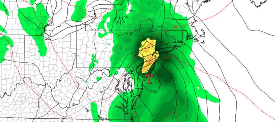
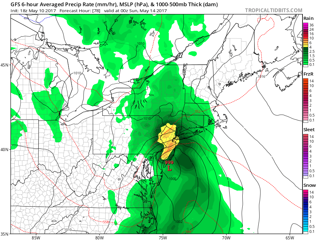
Discussion: I’ve watched this system disappear and re-appear while jumping between Saturday and Sunday for almost a week now on model guidance. Only now are the models beginning to key in on a specific time-frame which is late-Saturday morning through early Sunday morning. 500mb looks very uncertain with the southern shortwave racing ahead of the northern stream shortwave. The models indicate the best interaction happening closer to Monday for coastal New England. New Jersey will be subject to the two shortwaves pulling together overhead but not a full phase. We are talking about a powerful quick-hitting low pressure system should the systems interact more before passing over Jersey. If they struggle to interact before passing over Jersey then we’ll likely deal with a broken-up rain system. In learning from the past, it’s best to keep your expectations as wide as allowable by chaos when dealing with phasing upper-level energy. In this case it’s anything from moderate rainfall/winds to heavy rainfall/high winds between the stated time period. The latest GFS suggests something in the middle of that:
In English: Right now it looks like a mostly cloudy with sprinkles Friday, a wet (possibly really wet and windy) Saturday, followed by a cool but drier mother’s day. Exact rainy hours (statewide) look like late-Saturday morning (starting by noon) through early Sunday morning (ending by dawn). 1-3 inches of rainfall are possible, maybe even more in isolated locations. Winds should be moderate and possibly gusty out of the E/NE at times. I’ll have the detailed weekend outlook posted tomorrow night. Have a great night and please be safe! JC
Jonathan Carr (JC) is the founder and sole operator of Weather NJ, New Jersey’s largest independent weather reporting agency. Since 2010, Jonathan has provided weather safety discussion and forecasting services for New Jersey and surrounding areas through the web and social media. Originally branded as Severe NJ Weather (before 2014), Weather NJ is proud to bring you accurate and responsible forecast discussion ahead of high-stakes weather scenarios that impact this great garden state of ours. All Weather. All New Jersey.™ Be safe! JC


LOCAL FORECAST | INTERACTIVE RADAR | LATEST NJ WEATHER ALERTS | WEDDING FORECAST| PRIVACY POLICY
© Copyright 2026 Weather NJ LLC. All Rights Reserved.
Some information that can be found on our website is provided by a private weather station and is not an officially recognized station for weather reporting. Though we always strive to achieve accurate reporting for our own use, it is important that you do NOT depend on the data provided here for any purpose.
