

May 14: More Thunderstorms Detected
For full-resolution storm map, please click here!
Discussion: A Mesoscale Convective System (MCS) is currently pushing SW through Virginia and Maryland. It should further impact the Delmarva Peninsula over the next few hours. If certain criteria is met then it will be declared a Derecho. The severe stuff should stay to the S of NJ however SNJ could get clipped with some overnight showers and possibly a rumble or two.
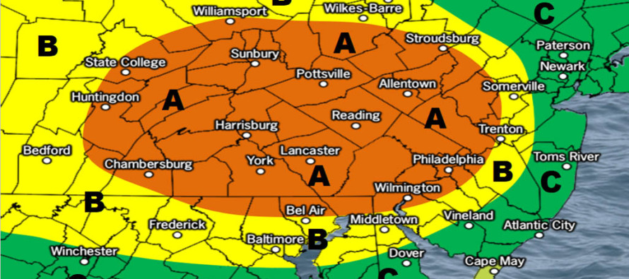
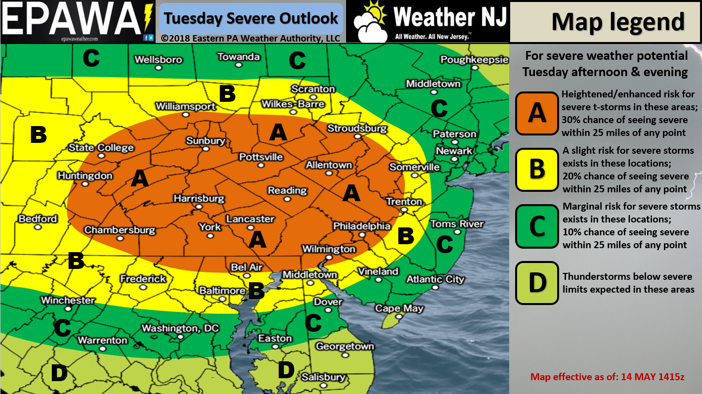
A warm front will then push through tomorrow morning and with it, the chance for more scattered showers and non-severe rumbles from sunrise through rush hour. Conditions should then become hazy, hot and humid during peak solar heating (daytime hours). This should destabilize the entire state ahead of a cold front which should move through from afternoon to evening (from NWNJ to SENJ). The frontal passage should lift the daytime-heated humid surface layer into the upper-levels and produce towering cumulonimbus clouds. This presents a severe weather threat for much of New Jersey. The above map represents our general idea as to where the most severe conditions will likely play out. All of NJ should prepare for this however.
In English: Scattered showers and maybe a few rumbles are possible overnight through tomorrow morning’s rush hour. A hazy, hot and humid day is then expected from late-morning through afternoon. Heavy rain and thunderstorms should then push through NJ from NW to SE between late-afternoon and evening hours. These thunderstorms could feature severe conditions. Winds gusts of 60mph+ and/or quarter-inch or larger hail are possible. Straight-line winds should be more likely than tornadic winds given the linear nature of the energy with the front. Make no mistake though, wind damage is very possible regardless. As the above map indicated, WNJ has a better chance at seeing severe conditions than ENJ mainly due to the stabilizing marine layer and other inhibiting factors. I would go ahead and play it safe by expecting severe conditions statewide just in case. 9 times out of 10 these storm lines fizzle to just showers for the coast. There’s always that 1/10 chance that they hold to the SENJ coast though. Ballpark timing: Approaches NWNJ around 5pm, crosses the I-95 corridor between 6-8pm and clears SENJ by 10-11pm. Tomorrow we can re-visit more detailed timing. Have a great night and please be safe! JC
For comprehensive and interactive hyper-local human analysis that goes way above and beyond the detail of this public forecast, check out our premium services which include early hyper-local text notifications and guaranteed individual forum interaction. A must for outdoor businesses that depend on the best real-time data possible.
Jonathan Carr (JC) is the founder and sole operator of Weather NJ, New Jersey’s largest independent weather reporting agency. Since 2010, Jonathan has provided weather safety discussion and forecasting services for New Jersey and surrounding areas through the web and social media. Originally branded as Severe NJ Weather (before 2014), Weather NJ is proud to bring you accurate and responsible forecast discussion ahead of high-stakes weather scenarios that impact this great garden state of ours. All Weather. All New Jersey.™ Be safe! JC


LOCAL FORECAST | INTERACTIVE RADAR | LATEST NJ WEATHER ALERTS | WEDDING FORECAST| PRIVACY POLICY
© Copyright 2026 Weather NJ LLC. All Rights Reserved.
Some information that can be found on our website is provided by a private weather station and is not an officially recognized station for weather reporting. Though we always strive to achieve accurate reporting for our own use, it is important that you do NOT depend on the data provided here for any purpose.
