

May 20: Rain to Kick-off Memorial Day Weekend!
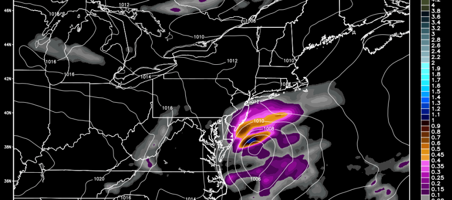
A weak low pressure system is modeled to track from Tennessee through the North Carolina/Virginia border area—bringing rain to New Jersey from Thursday night through Friday morning. Given that the low will pass to the S of New Jersey, SNJ and only parts of CNJ are favorable for rainfall. NNJ would likely see little to no precipitation from this. Given the synoptic positioning, SENJ would be subject to onshore flow late Thursday evening through early Friday morning meaning light-to-moderate wind with little-to-no coastal flooding impacts. The good news is that this will help set up a beautiful Friday afternoon through at least Sunday night. I’ll have a fully detailed Memorial Day Weekend Outlook posted tomorrow morning. For now, let’s focus on the Thursday PM-Friday AM disturbance. Here’s the latest NAM showing the disturbance and rainfall impacts late Thursday evening:
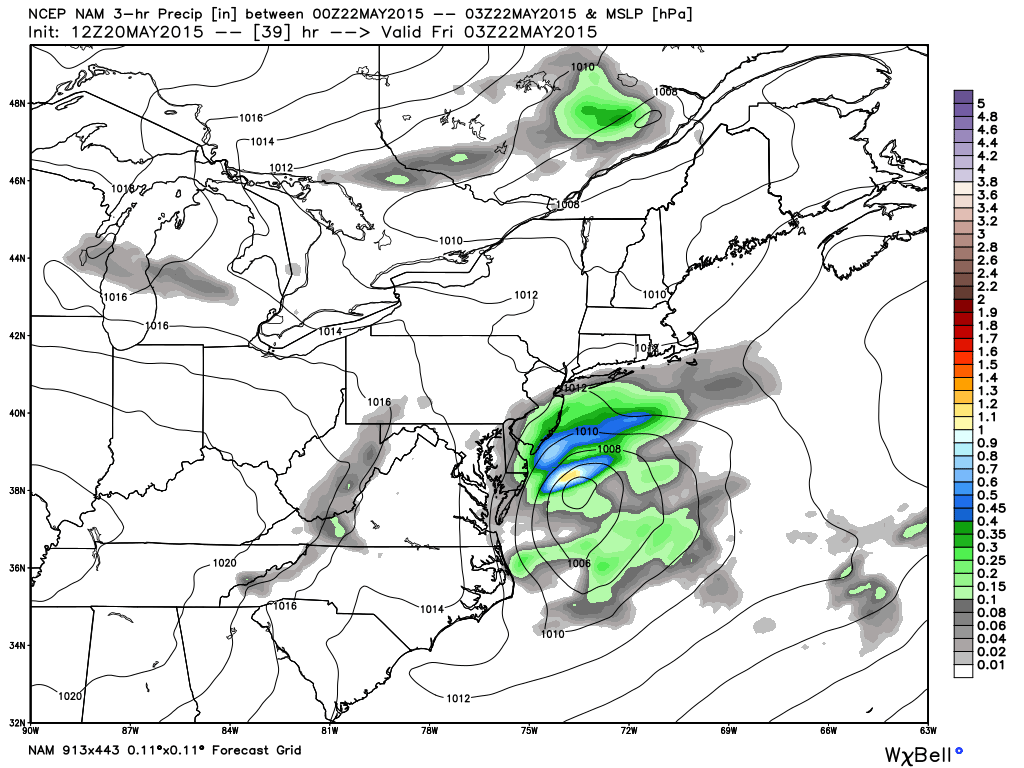
This next image represents the total modeled precipitation (rainfall in inches) from the disturbance through 6AM Friday morning, also pulled from the latest NAM. Amounts range from just a few tenths of an inch for the I-80/I-78 area up to 1.5 inches of rain for extreme SNJ:
In English: SNJ (especially SENJ) and parts of CNJ should expect breezy rain starting as early as Thursday afternoon and ending sometime early Friday morning. Once clear, most of Friday should be okay. As of right now the “meat and potatoes” of the weekend looks pretty good but again, stay tuned for my full Memorial Day Weekend Outlook which will be posted tomorrow morning. Have a great Wednesday and be safe! JC
Jonathan Carr (JC) is the founder and sole operator of Weather NJ, New Jersey’s largest independent weather reporting agency. Since 2010, Jonathan has provided weather safety discussion and forecasting services for New Jersey and surrounding areas through the web and social media. Originally branded as Severe NJ Weather (before 2014), Weather NJ is proud to bring you accurate and responsible forecast discussion ahead of high-stakes weather scenarios that impact this great garden state of ours. All Weather. All New Jersey.™ Be safe! JC


LOCAL FORECAST | INTERACTIVE RADAR | LATEST NJ WEATHER ALERTS | WEDDING FORECAST| PRIVACY POLICY
© Copyright 2026 Weather NJ LLC. All Rights Reserved.
Some information that can be found on our website is provided by a private weather station and is not an officially recognized station for weather reporting. Though we always strive to achieve accurate reporting for our own use, it is important that you do NOT depend on the data provided here for any purpose.
