

Mild and Wet Week Expected (Nov 28-Dec 2)

We’re looking mild and rainy this week followed by another cold shot for the weekend. Let’s break it down…
Disco: The main players on the table this week are a strong low pressure system, currently in the northern-central US, and high pressure in the general Bermuda region. The high pressure will provide return flow (southerly flow) for our region until the frontal boundary associated with the northern low completely passes through. We could see more than one disturbance form along this frontal boundary which could actually give us a small break between the rain on Wednesday. After that, we’re looking at strong W/NW flow between the departed low and a new area of weak high pressure drifing through the southern US. With that said, the best prognostication indicates a mild/breezy start to the week, a mild, breezy-possibly-gusty and wet mid-week, followed by a colder weekend.
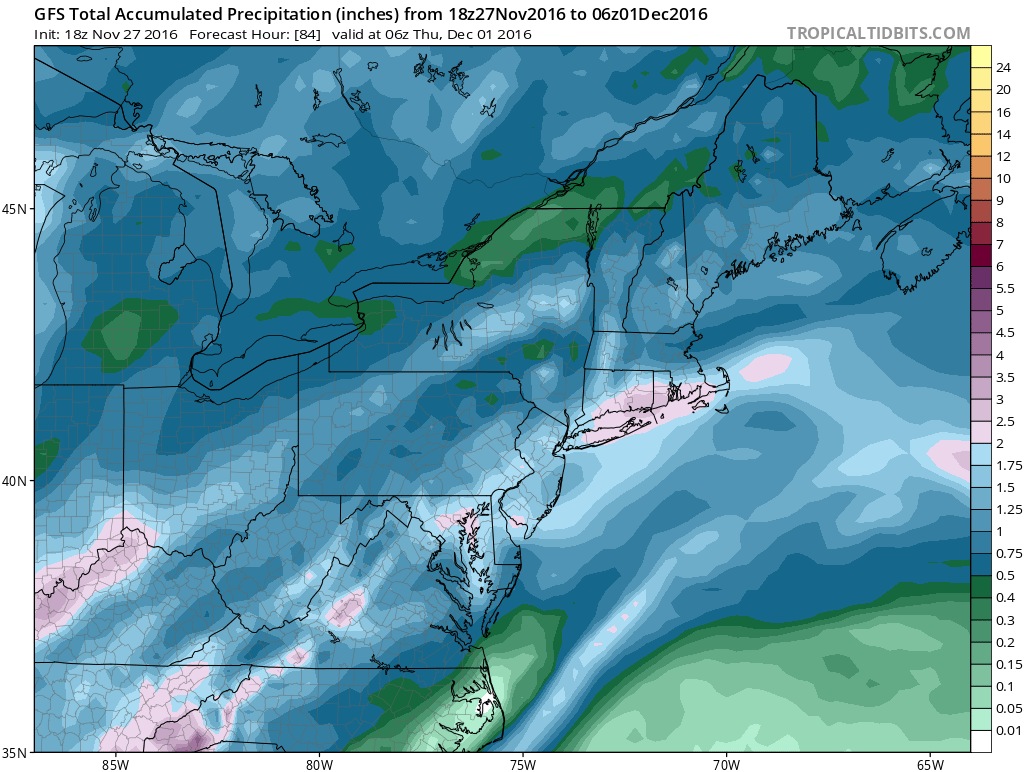
Here are expected total rainfall amounts, per 18Z GFS, through early Thursday AM. Rainfall would begin as early as Tuesday AM. It looks like anything from a half-inch to 1.5 inches in general for New Jersey with isolated instances of 2 inches:
Monday (Nov 28) high temperatures should reach into the 50s statewide. Skies should be partly sunny. Winds should be light out of the S. Overnight lows should fall into the 40s for most with NNJ elevations likely dipping into the 30s.
Tuesday (Nov 29) high temperatures should reach the upper-50s/lower-60s statewide. Skies should be mostly cloudy with periods of rain expected. Winds should be light-to-breezy out of the S and could possibly become gusty for PM hours. Overnight lows should fall into the 50s for most with NNJ elevations likely dipping into the 40s.
Wednesday (Nov 30) high temperatures should reach the upper-50s/lower-60s for most. Parts of CNJ and SNJ might even reach the mid-60s. Skies should be mostly cloudy with more periods of rain expected. Winds should remain breezy-to-gusty out of the S (30mph+ gusts possible). Overnight lows should fall into the 50s for most with NNJ elevations likely dipping into the 40s.
Thursday (Dec 1) high temperatures should reach the mid-to-upper 50s statewide. The cold front will be passing through but will not be felt until after sundown. Skies should be partly-to-mostly cloudy. We could see the sun poke through here and there. Winds should increase out of the W/NW as daytime hours transition to night. Overnight lows should fall into the 30s for most with NNJ elevations possibly dipping into the 20s while immediate coastal regions hover around 40.
Friday (Dec 2) high temperatures should struggle to escape the 40s statewide. Skies should feature a mixed-bag of sun and clouds. Winds should remain light-to-breezy out of the W/NW for the first part of the day and possibly subside overnight as lows bottom out in the 30s statewide.


An early look at the weekend indicates colder weather lasting well into next week. The only precipitation chances would be from lake-effect evaporation which we’ll have to play by radar. I’m not that thrilled by such. The bigger pattern change towards that of true winter is still expected in December which I’ll discuss in more detail tomorrow night in the December 2016 outlook. I have a feeling we’re not that far from our first widespread snow event. Everyone have a great weekend and please be safe! JC
Jonathan Carr (JC) is the founder and sole operator of Weather NJ, New Jersey’s largest independent weather reporting agency. Since 2010, Jonathan has provided weather safety discussion and forecasting services for New Jersey and surrounding areas through the web and social media. Originally branded as Severe NJ Weather (before 2014), Weather NJ is proud to bring you accurate and responsible forecast discussion ahead of high-stakes weather scenarios that impact this great garden state of ours. All Weather. All New Jersey.™ Be safe! JC


LOCAL FORECAST | INTERACTIVE RADAR | LATEST NJ WEATHER ALERTS | WEDDING FORECAST| PRIVACY POLICY
© Copyright 2026 Weather NJ LLC. All Rights Reserved.
Some information that can be found on our website is provided by a private weather station and is not an officially recognized station for weather reporting. Though we always strive to achieve accurate reporting for our own use, it is important that you do NOT depend on the data provided here for any purpose.

)