

Mild Conditions (Dec 11-13). But then…
Discussion: The upper jet will make several meridional fluctuations over the next few weeks over NJ. This should allow a few low pressure systems to pass just to the SE of NJ from W to E—putting parts of NJ on the snowy side of the low centers (the N and W side). The E US ridging is the most notable short-term observation. It’s why we’re currently seeing and will experience a milder weekend. Some isolated-to-scattered pockets of rain are possible as the warm front passes through from a low tracking well to NJ’s NW. Those showers would be most favored to happen between Saturday PM and Sunday AM. The rest of Sunday should feature improving skies with the dry cold front through.
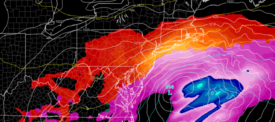
We then turn our eyes to a double hit of low pressure systems occurring in a pattern favorable for east coast snow. The Monday system features a weak wave-like sliding low to our S. The surface profile in NJ will still be above freezing from the milder weekend. However colder air will slowly be moving in and trickling down from aloft with the precipitation. NWNJ would have the best chance for snow. SENJ the best chance for rain. A fairly unpredictable battleground between from this range. Cold air is then pulled in behind that departing Monday system. This should set the stage for a colder pre-storm setup for the strong Wednesday-Thursday storm signal. That system looks colder, slower, and snowier with a strong high pressure block in SE Canada. Most major model runs today are almost unanimous in the Wed-Thurs snow storm happening for most of New Jersey. I’m now in serious tracking mode and will begin daily articles about both systems tomorrow. We’ll only be 2 days from the Monday system and 4 days from the Wednesday system. I just need to see one more night of model consensus tonight before I lock into more specific forecasting (expected snow totals, locations, etc.). In the meantime, enjoy the last milder period this weekend before we enter the wintry pattern.
Note: Unless specifically mentioned by location (Example: NNJ elevations, SENJ immediate coast, Interior CNJ/SNJ, etc.) assume the following forecast language is statewide for New Jersey. When I say “from elevations to sea” I mean from NWNJ mountains spreading down to immediate ECNJ/SNJ coastal areas. Directions are shortened (N = North, S = South, W/SW = West/SouthWest, etc.).
Friday (Dec 11) high temperatures are topping out in the mid-to-upper 50s. Skies should remain mostly sunny with a few friendly clouds here and there. Winds should remain light out of the S/SW. Overnight lows should range from near-30 in the elevations to near-50 near the coast.
Saturday (Dec 12) high temperatures should range from near-50 to near-60 from elevations to sea. Skies should be mostly cloudy with a mild feel. Can’t rule out a few showers. Winds should be light out of the SE. Overnight lows should range from near-40 to near-50 from elevations to sea.
Sunday (Dec 13) high temperatures should range from near-50 to near-60 from elevations to sea. Skies should start mostly cloudy with a few more showers around but then improve through PM hours. Winds should be light out of the W/SW. Overnight lows should range from near-30 to near-40 from elevations to sea.
An early look at next week indicates the milder conditions ending Monday. Still watching two disturbances for wintry potential. One for Monday (smaller system with rain/snow issues) and another for Wednesday into Thursday (bigger system with higher widespread snow potential). It’s safe to say serious tracking is now happening for both systems. Daily article updates will begin tomorrow.
Download the free Weather NJ mobile app on Apple or Android. It’s the easiest way to never miss Weather NJ content. Our premium services go even further above and beyond at the hyper-local level. Get your merch on at the KABOOM shop in time for the holidays.
Jonathan Carr (JC) is the founder and sole operator of Weather NJ, New Jersey’s largest independent weather reporting agency. Since 2010, Jonathan has provided weather safety discussion and forecasting services for New Jersey and surrounding areas through the web and social media. Originally branded as Severe NJ Weather (before 2014), Weather NJ is proud to bring you accurate and responsible forecast discussion ahead of high-stakes weather scenarios that impact this great garden state of ours. All Weather. All New Jersey.™ Be safe! JC


LOCAL FORECAST | INTERACTIVE RADAR | LATEST NJ WEATHER ALERTS | WEDDING FORECAST| PRIVACY POLICY
© Copyright 2026 Weather NJ LLC. All Rights Reserved.
Some information that can be found on our website is provided by a private weather station and is not an officially recognized station for weather reporting. Though we always strive to achieve accurate reporting for our own use, it is important that you do NOT depend on the data provided here for any purpose.

. But then…)