

Milder Build into Unsettled Weekend
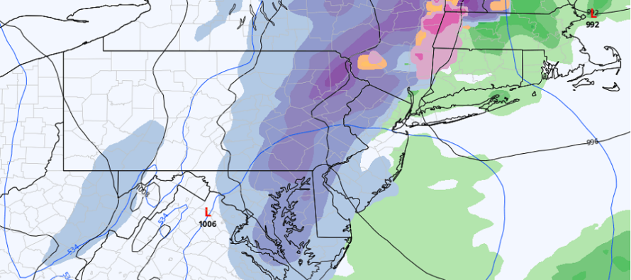
Discussion: Our weak wave has departed and we’ll now have fairly tranquil conditions through at least Thursday morning. A low pressure system is then expected to track from the central plains into the E Great Lakes area around Friday morning (the Jan 13-15 signal I’ve been tracking). This should drag a correlating frontal system through the entire E US late Thursday night into Friday morning. For this piece, we’re looking at very mild conditions (upper-40s/lower-50s) ahead of the front and then rain along the front. Given the ridge and high-pressure block orientation, low pressure should transfer from the E lakes to somewhere off the Mid-Atlantic US coast by late Friday night. This could rip some of the frontal precipitation back into the fresh-arriving cold for Saturday. Again, with the block these features will be crawling not racing. The Euro (pictured above) and Canadian are more bullish on this idea. The GFS has a quicker end with less ending snow. So, it looks like this event overall will start rainy and windy late Thursday night/Friday morning, see a break Friday afternoon-evening, redevelop Friday night, then either finish as snow further into Saturday (like Euro or Canadian) or finish earlier Saturday with little-to-no snow (like the GFS). You know I’ll be watching. We have a few days to iron out the expected details.
Monday (Jan 9) high temperatures are maxing in the low-to-mid 40s. 30s for elevations. Skies should remain mostly clear. Winds could become a little breezy at times out of the W/NW. Overnight lows should range from upper-20s to mid-30s from elevations to coasts.
Tuesday (Jan 10) high temperatures should reach into the lower-40s again. Skies should be mixed with sun and clouds. Winds should be light out of the W. Overnight lows should fall into the mid-to-upper 20s for most areas.
Wednesday (Jan 11) high temperatures should range from 40-50 from elevations to coasts. Skies should be mixed with sun and clouds. Winds should be light out of the E/NE. Overnight lows should fall into the 30s for most areas with light rain possible at times.
Thursday (Jan 12) high temperatures should range from upper-40s to lower-50s from elevations to coasts. Skies should be mixed with passing showers possible. Winds should be light-to-breezy out of the SE. Overnight lows should stay pinned in the upper-40s with more rain possible from an approaching frontal system
Friday (Jan 13) high temperatures should reach the low-to-mid 50s during the day. Skies should be mostly cloudy with more rain likely in the morning. A break in the rain is likely followed by precip returning possibly as snow, later Friday night into Saturday. Winds should be light-to-breezy out of the S/SW. Overnight lows should fall into the 30s for most areas.
An early look at the weekend indicates a colder and drier Saturday (once the redeveloping storm precip moves out) and Sunday. North flow behind the system will turn us colder but again, not brutally cold. We’ll see what happens Friday night into Saturday (will revisit daily) but otherwise, the snow lover’s drought could continue.
Premium Services
KABOOM Club offers inside info forecast discussion, your questions answered, and early storm impact maps (ahead of the public). At a buck per month, it’s an extremely feasible way to show support.
My Pocket Meteorologist (MPM), in partnership with EPAWA Weather Consulting, offers professional/commercial interests, whose businesses depend on outdoor weather conditions (snow plowing, landscaping, construction, etc.), with hyper-local text message alerts/forecasts and access to the MPM premium forum—the most comprehensive and technical forecast discussion available for PA and NJ.
Jonathan Carr (JC) is the founder and sole operator of Weather NJ, New Jersey’s largest independent weather reporting agency. Since 2010, Jonathan has provided weather safety discussion and forecasting services for New Jersey and surrounding areas through the web and social media. Originally branded as Severe NJ Weather (before 2014), Weather NJ is proud to bring you accurate and responsible forecast discussion ahead of high-stakes weather scenarios that impact this great garden state of ours. All Weather. All New Jersey.™ Be safe! JC


LOCAL FORECAST | INTERACTIVE RADAR | LATEST NJ WEATHER ALERTS | WEDDING FORECAST| PRIVACY POLICY
© Copyright 2025 Weather NJ LLC. All Rights Reserved.
Some information that can be found on our website is provided by a private weather station and is not an officially recognized station for weather reporting. Though we always strive to achieve accurate reporting for our own use, it is important that you do NOT depend on the data provided here for any purpose.
