

Mixed Conditions (Aug 24-28)
Discussion: Let’s first talk about the setup for NJ before we talk about the tropics. We currently have a progressive trough swinging through the NE US. It’s nose will push through the N Mid-Atlantic US (NJ) on Tuesday which could produce a severe storm front for NJ Tuesday PM. Since the frontal energy will move from N to S, we can expect storms to start in NNJ as early as afternoon and end for SNJ later in the evening. Damaging winds and hail are possible for the storm front so we will watch closely. Once that clears out, late-Tuesday night through Wednesday then looks gorgeous with lower humidity. By Thursday the heat and humidity return to set up the weekend. Now let’s discuss the tropics…
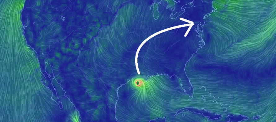
Tropics: Tropical Storm Marco is currently fizzling out near New Orleans. That was the first of the two storms we’ve been tracking. Tropical Storm Laura is next and the more important one. Laura us currently crossing W Cuba and is about to emerge over open Gulf of Mexico waters. These waters are warm and capable of fueling rapid tropical development. Therefore, I expect Laura to become possibly a major hurricane at some point in the Gulf of Mexico. It should then make landfall somewhere between Houston, TX and New Orleans, LA in the ~Wednesday evening period. With some hope, dry air and maybe some wind sheer could get involve and weaken Laura prior to landfall. Such is not guaranteed though. After landfall, Laura will unravel its cyclonic tropical core and get picked up by the zonal westerlies across the US. This flow could very well drag Laura’s remnants over NJ as a rainy/stormy blob. This blob will not be in the form of a tropical storm but could enhance thunderstorms to the point of severe criteria, should it hit between next Friday night and Sunday morning (mainly on Saturday). I’ll be watching both the Tuesday night severe thunderstorm and Saturday Laura remnant possibilities.
Note: Unless specifically mentioned by location (Example: NNJ elevations, SENJ immediate coast, Interior CNJ/SNJ, etc.) assume the following forecast language is statewide for New Jersey. When I say “from elevations to sea” I mean from NWNJ mountains spreading down to SENJ coastal areas. Directions are shortened (N = North, S = South, W/SW = West/SouthWest, etc.).
Monday (Aug 24) high temperatures are currently maxing out near-90. With widespread dew points in the 70s (high humidity), that likely feels more like upper-90s to 100. Showers and thunderstorms are possible through remaining PM hours. Winds are currently light out of the W/SW, a little breezier for SENJ off the Delaware Bay. Overnight lows should range from mid-60s to lower-70s from elevations to sea.
Tuesday (Aug 25) high temperatures should reach near-90 again. Skies should be partly cloudy with a humid feel. Severe thunderstorms are possible during PM hours. I’ll be monitoring closely as anything from hail to damaging winds are possible. Winds should be light-to-breezy out of the W ahead of the storms. Overnight lows should fall into the 60s for most, possibly 50s for NNJ elevations.
Wednesday (Aug 26) high temperatures should reach near-80 with a more pleasant and drier feel. Skies should be mixed with sun and clouds. Winds should be light out of the NW. Overnight lows should range from mid-50s to upper-60s from elevations to sea.
Thursday (Aug 27) high temperatures should reach closer to 90, possibly mid-90s for interior CNJ/SNJ. Humidity will be noticeably returning. Skies should be mixed with sun and clouds. Winds should be light out of the S/SW. Overnight lows should range from upper-60s to mid-70s from elevations to sea.
Friday (Aug 28) high temperatures should reach the mid-to-upper 80s for most. Interior CNJ/SNJ would have the best chance to reach 90. Skies should transition from mostly sunny to mostly cloudy with humidity lingering. Winds should be light out of the W/SW. Overnight lows should range from upper-60s to lower-70s from elevations to sea. All eyes will be on Laura’s remnants for Friday night into the weekend.
An early look at the weekend indicates uncertain conditions surrounding the path of Laura’s remnants. It is possible we see a rainy/stormy blob come through NJ between Friday night and Sunday morning. We will have to observe as we get closer. A washout is on the table however if the remnants do pass over NJ. Everyone have a great week and please be safe! JC
Download the new free Weather NJ mobile app on Apple and/or Android. It’s the easiest way to never miss Weather NJ content. Our premium services go even further above and beyond at the hyper-local level. Looking for industrial-caliber long-range forecasting data that I personally recommend? Check out WeatherTrends360! Visit the Weather NJ Kaboom Shop for hoodies, tees and infant onesies.
Jonathan Carr (JC) is the founder and sole operator of Weather NJ, New Jersey’s largest independent weather reporting agency. Since 2010, Jonathan has provided weather safety discussion and forecasting services for New Jersey and surrounding areas through the web and social media. Originally branded as Severe NJ Weather (before 2014), Weather NJ is proud to bring you accurate and responsible forecast discussion ahead of high-stakes weather scenarios that impact this great garden state of ours. All Weather. All New Jersey.™ Be safe! JC


LOCAL FORECAST | INTERACTIVE RADAR | LATEST NJ WEATHER ALERTS | WEDDING FORECAST| PRIVACY POLICY
© Copyright 2026 Weather NJ LLC. All Rights Reserved.
Some information that can be found on our website is provided by a private weather station and is not an officially recognized station for weather reporting. Though we always strive to achieve accurate reporting for our own use, it is important that you do NOT depend on the data provided here for any purpose.

)