

Mixed Conditions. Watching Wednesday.
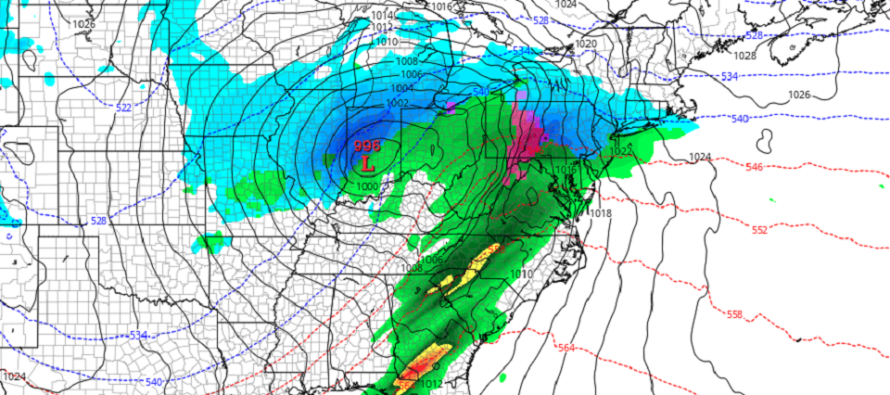
Discussion: The weak low associated with last night-this morning’s precipitation is now E of NJ. Winds have now become northerly for most of NJ and temperatures have dropped enough to return some areas that started wintry and changed to rain, back to wintry. Precipitation is rushing to a finish though so accumulations are limited to just little-to-none. The best chance to eek out a coating to an inch or two would be the highest elevations of Sussex County. Otherwise precip will end, skies will improve, and winds will hold stiff out of the W/NW. We’re then tranquil and colder Monday night through most of Tuesday. Wednesday is our next system. We have a low tracking well to the NW of NJ (near the E Lakes). Before the warm air advects off the ocean and changes all areas over to rain (by Wednesday night), we have a snowy thump possibility for at least NWNJ (earlier Wednesday) possibly much lower in NJ. There’s no doubt precip will eventually changeover to rain for all areas. The question is, how much overrunning precip can fall as snow ahead of the warm front. Stay tuned for an article later today focused on this system. More cold air will then move in behind the departing system for Thursday into the weekend. Not brutal Arctic cold air (like around Christmas. Ex: high of 20 low of 5)…but the same stale Canadian cold air mass we’ve been seeing since (Ex: high of 38-43 low of 23-37). There might be a clipper-like frontal system Saturday but likely just conversational at most. I know this winter has been rough for the snow lover. We’re pretty much at half-time (middle of the 4th inning) or however you wish to assign a timer to the snow season. Still a lot of time left but I get it, it feels like we’re down 6 runs to 0. The only thing I can say is that February should open up a window to a better pattern…a pattern where winter could make a comeback if it wanted to. I don’t see any specific threats but I do see more of a meridional pattern with more sustained troughs and cold setting in. Every 7-10 days at a time! If you were around for 2003, 2007, 2010, 2014, 2018, and a handful of other NJ winters, you know how foolish it would have been to cancel winter at the end of January. Again, I feel your suffering as a snow lover but let’s let it play out.
Monday (Jan 23) high temperatures should reach near-40 for most areas. Skies should start out mostly cloudy with rain changing to snow NW of 95/NJTP. A coating to an inch or so is possible, especially elevations, before precip ends by noon for everyone. Ending flakes could push SE of 95/NJTP but would be conversational and likely without stickage. Skies should improve afternoon-forward as temps drop through sunset. Winds should be breezy out of the W/NW. Overnight lows should fall into the upper-20s away from the ocean and likely near-freezing for coasties. Winds should begin to subside overnight.
Tuesday (Jan 24) high temperatures should reach the mid-40s for most areas of NJ. Skies should be mixed with sun and clouds. Winds should relax to just light out of the W. Overnight lows should fall into the mid-to-upper 20s for most locations away from the ocean. Near-freezing along the coast just like Monday night.
Wednesday (Jan 25) high temperatures should range big from NWNJ to SENJ (lower-30s to near-50) but should be reached later at night. Skies should gradually increase in cloud coverage throughout the day with precip moving in likely by afternoon. I’m monitoring an initial snowy thump for at least NWNJ, possibly down to the turnpike or even SE of that, before going over to rain. Coast likely roasted out by the onshore flow from start to finish (all rain). With that said, expect breezy-to-gusty E/SE winds. But NWNJ could see a nice little wintry surprise Wednesday afternoon-evening (more to come later today). Wednesday night would then be mostly rain for all heading into Thursday morning with lows in the 35-43 range (NWNJ to SENJ).
Thursday (Jan 26) high temperatures should reach the low-to-mid 40s for most areas. Skies should be mixed with sun and clouds. Winds should be breezy, possibly gusty at times, out of the W. Overnight lows should range from near-20 to near-30.
Friday (Jan 27) high temperatures should struggle to escape the upper-30s anywhere in NJ. Skies should be mixed with sun and clouds. Winds should be light of the W. Overnight lows should again range from near-20 to near-30.
An early look at the weekend indicates colder conditions (closer to average) lasting. Highs capped in the upper-30s/lower-40s. Lows in the 20-30 range. Some very light snow signals showing for Saturday nothing serious yet. Temps are then expected to turn even colder for the following week as winter has another opportunity to make a comeback. Nothing specific worth tracking yet, just a window opening in the pattern. You’ll likely here more from me shortly about Wednesday PM. Have a great week and please be safe! JC
Premium Services
KABOOM Club offers inside info forecast discussion, your questions answered, and early storm impact maps (ahead of the public). At a buck per month, it’s an extremely feasible way to show support.
My Pocket Meteorologist (MPM), in partnership with EPAWA Weather Consulting, offers professional/commercial interests, whose businesses depend on outdoor weather conditions (snow plowing, landscaping, construction, etc.), with hyper-local text message alerts/forecasts and access to the MPM premium forum—the most comprehensive and technical forecast discussion available for PA and NJ.
Jonathan Carr (JC) is the founder and sole operator of Weather NJ, New Jersey’s largest independent weather reporting agency. Since 2010, Jonathan has provided weather safety discussion and forecasting services for New Jersey and surrounding areas through the web and social media. Originally branded as Severe NJ Weather (before 2014), Weather NJ is proud to bring you accurate and responsible forecast discussion ahead of high-stakes weather scenarios that impact this great garden state of ours. All Weather. All New Jersey.™ Be safe! JC


LOCAL FORECAST | INTERACTIVE RADAR | LATEST NJ WEATHER ALERTS | WEDDING FORECAST| PRIVACY POLICY
© Copyright 2026 Weather NJ LLC. All Rights Reserved.
Some information that can be found on our website is provided by a private weather station and is not an officially recognized station for weather reporting. Though we always strive to achieve accurate reporting for our own use, it is important that you do NOT depend on the data provided here for any purpose.
