

Monday Snow Update
Discussion: As far as this weekend goes, we still look mild and rainy in New Jersey…tonight (Friday night – New Years Eve) through Sunday night. For Saturday and Sunday, afternoon temps should range from lower-50s to upper-50s from NWNJ elevations to SENJ coasts.
Expect a few flat lows to move through from W/SW to E/NE. The first 1-2 should pass through and bring the weekend rain. The last wave is the one I am watching for a wintry finish Monday morning. Therefore, if this snow event is going to happen then Sunday night rain should transition to Monday morning snow. I expect nothing but above-freezing temperatures and rain through Sunday night/early Monday-AM.
Model guidance is continuing to favor a light-to-plowable SENJ snow event with NWNJ, possibly also the I-95/NJTP axis, left whiffing cirrus clouds. To be clear, that would mean little-to-no snowfall for said areas. But for SENJ, we’re looking at temperatures crashing below freezing early Monday morning with precipitation lingering until Monday afternoon. This could allow an ~early morning to ~noon snowfall window.
The upper levels will obviously be cold enough. The 700mb layer should crash below freezing for all of NJ by midnight Sunday night. 850mb should do the same by 2am Monday. The surface should crash to freezing or just below by 5am. So, it is likely that some snow accumulation potential could be robbed between rain changing to snow and the surface cooling to near-freezing. This would probably only be an hour or two prior to sunrise Monday. And again this is primarily for SENJ. The thermal profile is of higher confidence with an approaching high driving N flow into the top of this system behind the departing low…N flow is going to bring the temp drop Monday morning.
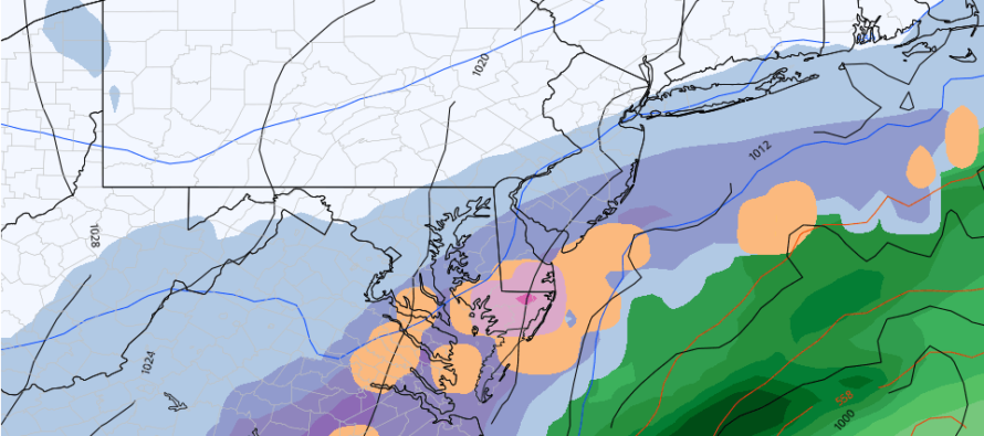
The N and NW extent of the precipitation shield is the biggest uncertainty IMO. It’s a flat and quicker system. Does it just graze Cape May with light outer-edge snow showers (like the Euro currently shows)? Does it push further into NJ, possibly to I-95 (like the GFS (above image) and RGEM show)? This is what I will be focused on when reviewing the next 24 hours of model guidance and live observations. I am curious if the models are handling the lake effect injection of moisture properly and also curious how the cyclonic vorticity profile further evolves. It’s been wrapping up tighter and any more of that could mean a stronger surface low. I am also curious about the Jan 7 (next Friday) signal that I am now casually monitoring in the long range.
In English: I am now tracking Monday snow seriously at least for SENJ, possibly some areas to the N and W of such. It doesn’t look like a major event but could yield a plowable event in it’s higher possible range of possibilities. The cover image of this article is from the GFS model suggesting snow falling on NJ Monday morning. It does not indicate expected amounts, just precipitation type and intensity for a 6-hour period of Monday morning. Tomorrow I will start to discuss expected amounts and how far into NJ the snow could reach. But the SNJ/SENJ express snow train might be coming. Until then expect the weekend to continue gray, wet, and mild. The changeover to snow would happen early Monday morning. Additionally another snow signal is on my radar for the ~Jan 7 period. Everyone please have a happy new year and be safe! JC
Download the free Weather NJ mobile app on Apple or Android. It’s the easiest way to never miss Weather NJ content. Our premium services go even further above and beyond at the hyper-local level.
Jonathan Carr (JC) is the founder and sole operator of Weather NJ, New Jersey’s largest independent weather reporting agency. Since 2010, Jonathan has provided weather safety discussion and forecasting services for New Jersey and surrounding areas through the web and social media. Originally branded as Severe NJ Weather (before 2014), Weather NJ is proud to bring you accurate and responsible forecast discussion ahead of high-stakes weather scenarios that impact this great garden state of ours. All Weather. All New Jersey.™ Be safe! JC


LOCAL FORECAST | INTERACTIVE RADAR | LATEST NJ WEATHER ALERTS | WEDDING FORECAST| PRIVACY POLICY
© Copyright 2026 Weather NJ LLC. All Rights Reserved.
Some information that can be found on our website is provided by a private weather station and is not an officially recognized station for weather reporting. Though we always strive to achieve accurate reporting for our own use, it is important that you do NOT depend on the data provided here for any purpose.
