

More Rain Detected
Forecast Discussion: The system that began impacting New Jersey on Friday night (Sept 22) has finally cleared out (as of last night – Tuesday night). A very prolonged event originally initiated by tropical storm remnants and ultimately sustained as a coastal low powered by fizzling upper-level remnants. The most intense period of the system occurred on Saturday re: rainfall, winds, and coastal flooding. We then had a break Saturday evening into Sunday morning. Then from Sunday through Tuesday night, rainfall was on-and-off with more of a misty/light rain nature rather than heavy-drop downpours…very typical of warmer core systems with wind-blown rainfall. We now have a few days (today and tomorrow) of what I refer to as awesome September weather conditions. More sun than clouds, onshore breeze, and low humidity…but still warm enough to go outside with comfort. It will stay this way until Friday.
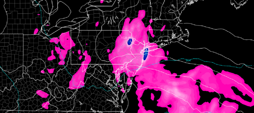
Believe it or not, a very small piece of the upper energy, from the past weekend remnants, over the ocean is expected to scoot back (retrograde) and join up with another upper-low to push through this Friday. From now until Saturday morning, we can expect the fetch (E winds) off the ocean to continue as high-pressure meanders over the NE US while the energy builds S/SE of NJ and moves in. This means onshore flow (E winds) will continue up to and through Friday’s rain. By sunrise Saturday morning, the rain should be pulling away to the E of NJ and winds will become N/NE for the rest of the weekend.
I expect rainfall to move into NJ between late Thursday night and early Friday morning. Winds should intensify slightly with the arrival of precipitation. Rain (on-and-off) and wind should continue until sometime between early Saturday AM and sunrise Saturday. Rain should shut off by 9am Saturday rendering drier, cooler, and breezier days Saturday and Sunday. Coastal flooding will be an issue (mostly minor levels) from now through at least Saturday. Coastal flooding impacts should subside Saturday as winds switch from onshore to northerly.
This Friday rain event is the last rain I see for some time. This Saturday through all of next week and even next weekend looks dry with upper-level ridging/ mid-level high pressure in control of the E US. It’s far out but I am then seeing a trough move in for the Oct 9-12 period which could feature an initial frontal rain system followed by a rude awakening of cold behind it. Let’s casually monitor this in the long range for now.
In English: Today and tomorrow are refreshing with comfortable/cooler temperatures, lower humidity, more sun than clouds, and winds off the ocean. A common theme from today through at least Saturday morning will be winds off the ocean producing higher tidal cycles. Rain should move in either late Thursday night or early Friday morning and fall, on-and-off, through sunrise Saturday morning. Onshore winds should ramp up a bit during the rainfall. On Saturday morning, rain should push offshore and NJ should be left with improving conditions despite cooler N/NE winds lasting the rest of the weekend. It looks very dry from this Saturday through next week/weekend. Have a great rest of your Wednesday and please be safe! JC
Premium Services
KABOOM Club offers inside info forecast discussion, your questions answered, and early storm impact maps (ahead of the public). At 99 cents per month, it’s an extremely feasible way to show support.
My Pocket Meteorologist (MPM), in partnership with EPAWA Weather Consulting, offers professional/commercial interests, whose businesses depend on outdoor weather conditions (snow plowing, landscaping, construction, etc.), with hyper-local text message alerts/forecasts and access to the MPM premium forum—the most comprehensive and technical forecast discussion available for PA and NJ.
Jonathan Carr (JC) is the founder and sole operator of Weather NJ, New Jersey’s largest independent weather reporting agency. Since 2010, Jonathan has provided weather safety discussion and forecasting services for New Jersey and surrounding areas through the web and social media. Originally branded as Severe NJ Weather (before 2014), Weather NJ is proud to bring you accurate and responsible forecast discussion ahead of high-stakes weather scenarios that impact this great garden state of ours. All Weather. All New Jersey.™ Be safe! JC


LOCAL FORECAST | INTERACTIVE RADAR | LATEST NJ WEATHER ALERTS | WEDDING FORECAST| PRIVACY POLICY
© Copyright 2026 Weather NJ LLC. All Rights Reserved.
Some information that can be found on our website is provided by a private weather station and is not an officially recognized station for weather reporting. Though we always strive to achieve accurate reporting for our own use, it is important that you do NOT depend on the data provided here for any purpose.
