

More Snow Detected for New Jersey
Discussion: The last flakes have cleared the coast, and this storm is history. What an incredibly challenging storm to forecast. The entire E US felt like it had a million moving parts in the atmosphere. Nothing big, solid, or easy to grasp. The timing and interaction of the northern and southern pieces of upper-level energy made a fool of most forecasters at times including myself. That and the fact that computer model guidance collectively knee-jerked N, and then knee-jerked back further S in the last 48 hours…it was crazy IMO. Not a historic system snow-wise but historically difficult to nail down the specifics in the last few days. At least we were talking about it for a while, and the public knew that it was primarily a high-impact NNJ event with lesser impacts for CNJ/SNJ. Our second release map earlier yesterday was closer to verification than the last-minute one we cranked out last night. But NNJ still got their KABOOM. CNJ saw solid significant/major snow. SWNJ did better than SENJ but SNJ overall was a flop. Can’t say I am surprised about SNJ. We always knew that SNJ surface temps would struggle to dip to 32F. If the precipitation didn’t break apart (dry slots) this morning, then I think even SNJ would have just verified with a widespread C-2/1-3 across the southern NJ zones. But instead, most SNJ are lacking accumulation with most coatings, if any, melted already.
I hope no one forgot that this storm was the pattern opener of a more favorable environment for snowstorm development. Granted, we’ll be navigating the second half of February (bottom of 7th inning through 8th inning of winter). Sun angle is becoming a problem as SNJ saw with today’s sunrise. It must puke snow to stick during the day now and this will become more of a problem for daytime snow accumulation the closer we get to March, and especially in March. Climatologically, high temperatures simply want to reach the 40-48 degree range (NNJ to SNJ) for afternoon high temperatures. This new pattern is going to hold us in about the 38-45 range for the rest of this week including the weekend with Saturday likely the coldest day. No it’s not a frigid pattern as much as it is a favorable winter storm development pattern given the teleconnections and jet stream orientation. So we could be looking at multiple snow events but with a lot of white rain for daytime snowfall and reduced stickage at night even as overnight temps climb with seasonal climatology. But here we are and here we go.
Today should become windier as the low deepens out in the ocean (S of Cape Cod). That will mean NW or W/NW flow for us in the form of 25-35mph gusts at the surface. These winds should subside by tomorrow morning as the low’s outer winds pull away to the E. The next few days look dry with highs ranging from mid-30s to mid-40s from NNJ elevations to SNJ coasts. Overnight lows should fall into the teens for snow-packed NNJ areas with CNJ/SNJ down to the 20s/near-freezing along coast.
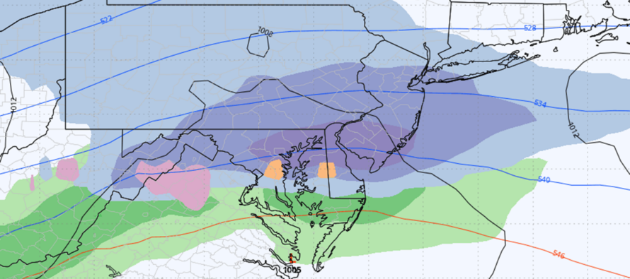
We then have three systems I’m eyeing up for the next week or so. First is a clipper with the low targeting NY State and New England. The low will have a cold front attached to the S of it that could bring a light mix of snow and rain to New Jersey late Thursday night into Friday morning. Very light showers as of now with a snow/rain line currently splitting NJ in half around I-195…low impacts for NJ, heavier impacts for NY State and New England. Here’s the modeled frame of highest precipitation activity late Thursday night into early Friday morning. Again, not a big deal.
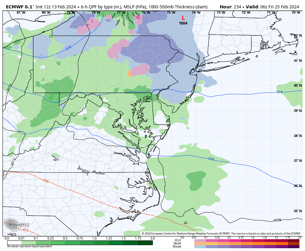
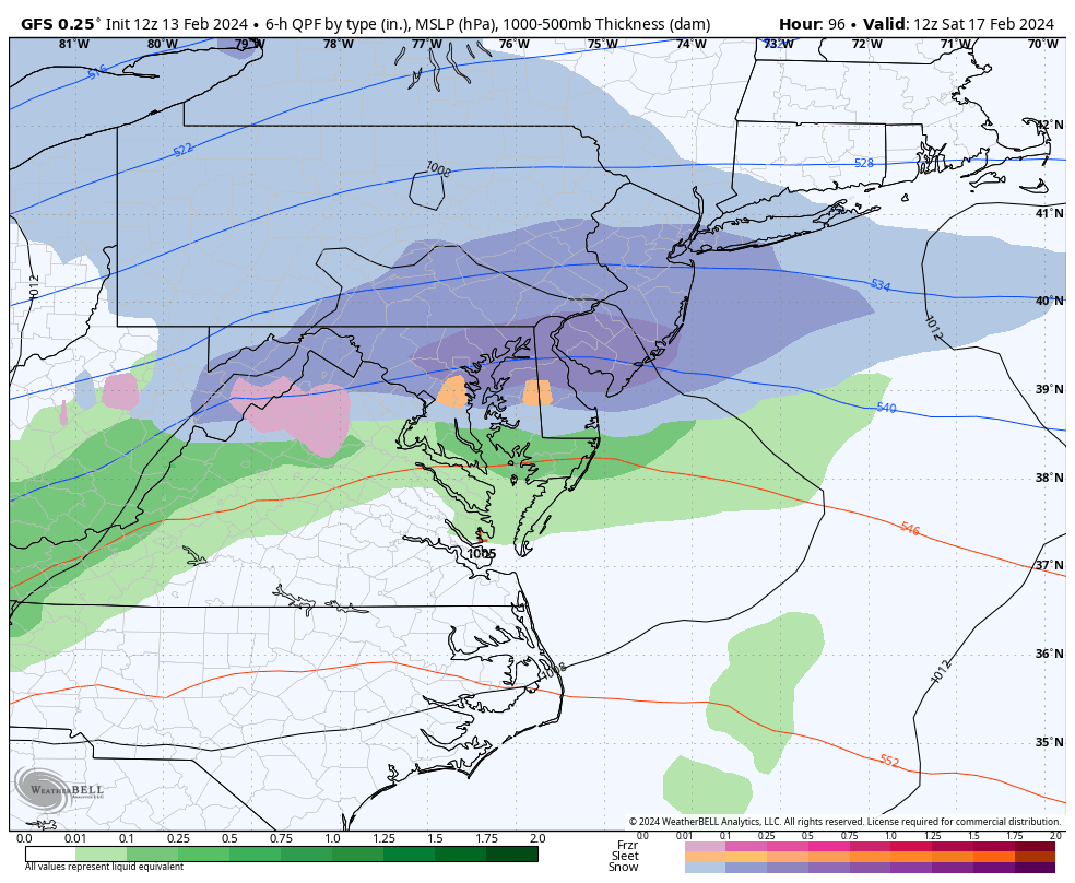
Then we have the Friday night into Saturday morning possibility which I like better for SNJ snow. This is a northern pacific jet low that crosses the US and trails the clipper but has impacts lower along the east coast. This low is currently targeting Maryland, Delmarva, and SNJ for the best snow. Here are the latest GFS and Euro runs showing the system this Friday night into Saturday morning (just a little over 3 days away from beginning). This is not far away:
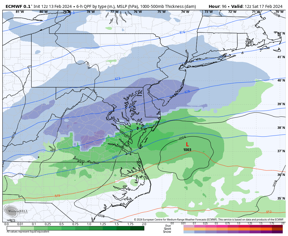
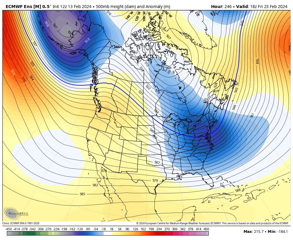
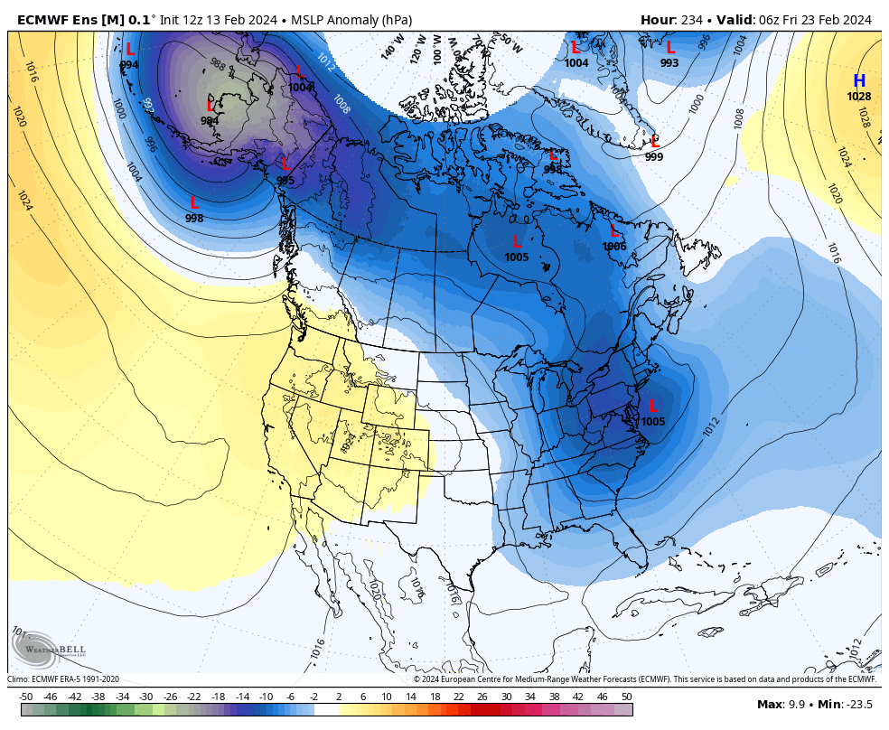
The third potential is the furthest out (Feb 22-24). It doesn’t make sense to discuss any details other than the loose suggestion of organizing low pressure off the east coast in that time frame. But it does look like temperatures could moderate a little between this upcoming Saturday’s potential and something later next week….a few days where NNJ could hit 40+ and SNJ hits near-50. That would be from Sunday-Tuesday of next week. We would then go back to colder for the third storm signal seen here on upper level heights and surface pressure anomalies:
Beyond the Feb 22-24 period, the longer-range Euro weeklies still suggest a W US ridge/E US trough pattern to close out February and go well into March. We’ll be fighting sun angle very hard and it will pretty much have to puke snow at night for stickage. But we have seen it before in March (2014, 2017, and 2018) so it’s not off the table. I personally would like to see a nice weak event for everyone this Saturday (get SNJ areas who missed out this morning) followed by a biggy later next week…and then bring on a warmer early spring like that certain rodent suggested. But as of now, the data suggests a back-loaded winter likely out to the end of calendar winter. 6 outs left in the ballgame.
Lastly, thank you all for your patience and understanding in our forecasting process. Welcome to all new followers of Weather NJ and thank you to existing followers for the overwhelming support of my passionate hobby. My primary intention is to use this for safety awareness. My secondary intention is to have fun with it, especially when snow is involved.
In English: Storm is over. NNJ KABOOMED, CNJ saw solid significant snow, and SNJ saw little-to-nothing because precipitation dry-slotted and didn’t cool the surface enough for stickage. About what was expected for most of the week leading up to this thing. The last-minute knee-jerking Sunday and yesterday threw us all for a spin…but we mostly ended up where we were discussing for the last 7 days or so. A little windy the rest of today/tonight but then wind relaxes by tomorrow morning. We then have a few seasonably chilly dry days (Wed-Thurs) and then some weak snow/rain showers Thursday night into Friday morning…very low impact for NJ. But then a stronger wave-like system could bring more snow accumulations to CNJ/SNJ Friday night into Saturday morning. Then a milder break Sunday through mid-next-week. And lastly a return to colder temperatures for a larger storm signal later next week (Feb 22-24). Have a great rest of your Tuesday and please be safe! JC
Premium Services
KABOOM Club offers inside info forecast discussion, your questions answered, and early storm impact maps (ahead of the public). At a buck per month, it’s an extremely feasible way to show support.
My Pocket Meteorologist (MPM), in partnership with EPAWA Weather Consulting, offers professional/commercial interests, whose businesses depend on outdoor weather conditions (snow plowing, landscaping, construction, etc.), with hyper-local text message alerts/forecasts and access to the MPM premium forum—the most comprehensive and technical forecast discussion available for PA and NJ.
Get your KABOOM Inside Out pajamas and more at the KABOOM shop!
Jonathan Carr (JC) is the founder and sole operator of Weather NJ, New Jersey’s largest independent weather reporting agency. Since 2010, Jonathan has provided weather safety discussion and forecasting services for New Jersey and surrounding areas through the web and social media. Originally branded as Severe NJ Weather (before 2014), Weather NJ is proud to bring you accurate and responsible forecast discussion ahead of high-stakes weather scenarios that impact this great garden state of ours. All Weather. All New Jersey.™ Be safe! JC


LOCAL FORECAST | INTERACTIVE RADAR | LATEST NJ WEATHER ALERTS | WEDDING FORECAST| PRIVACY POLICY
© Copyright 2026 Weather NJ LLC. All Rights Reserved.
Some information that can be found on our website is provided by a private weather station and is not an officially recognized station for weather reporting. Though we always strive to achieve accurate reporting for our own use, it is important that you do NOT depend on the data provided here for any purpose.
