

More Thunderstorm Potential Tonight
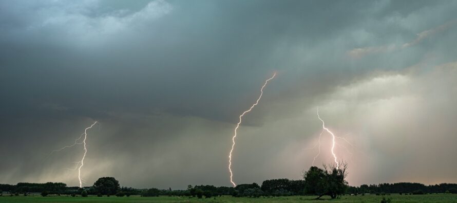
Discussion: The most important weather scenario to discuss is this evening. Last night’s storms petered out for many to just a rainy breeze, but we are lucky. The dynamics were there for severe/tornado potential. If I had to make that forecast again, I’d do the same thing in the interest of safety. It’s better to err on the side of caution. I basically have a similar forecast tonight. This time we have a low tracking across Delmarva and SNJ instead of across EPA/NNJ. If you look at the temps today (Tuesday) they are divided. NNJ is currently in the upper-60s/lower-70s with lower humidity. CNJ and SNJ are sitting near-90 with higher humidity (storm fuel). Therefore, I think tonight’s storm activity will follow the temp guidelines meaning stormier for CNJ/SNJ (where there’s more storm fuel) than NNJ (where there is less storm fuel). So, for CNJ/SNJ, we have a very good chance of downpours, gusty winds, and lightning with a lesser probability (but not zero) of flash flooding or isolated tornadoes. NNJ has a better chance to see non-severe storms or even just rain/breeze only. This action should approach SWNJ very soon (by 5pm). Let’s allow through 10pm for the action to push through all of NJ (mainly CNJ/SNJ) but it will likely be over sooner than that. 5-8pm is likely the main storm window. As in most cases, tonight it a hit-or-miss situation where some parts of NJ might not see anything while others experience severe thunderstorm conditions. The tropics remain eerily quiet as we continue to approach peak hurricane season.
Tuesday (Aug 15) high temperatures are varying from N to S. Parts of NNJ are near 70 while much of SNJ is near-90 with higher humidity levels. Skies will remain sunny until rain and thunderstorms move in from the W this evening. CNJ and SNJ are favored for the best thunderstorm dynamics. NNJ might be more of another breeze rain like last night. Hit-or-miss so not all will see storms. But those who do could get it good. Storms should approach SWNJ by 5pm and push through NJ to the ocean by midnight (likely earlier). Gusty winds, downpours capable of flash flooding, and lightning represent the most realistic probability. Small chance of an isolated tornado is not off the table as a lesser probability. I’ll be posting radar updates accordingly.
Wednesday (Aug 16) high temperatures should reach the low-to-mid 80s for most NJ locations. Skies should be mixed with sun and clouds. Can’t rule out an isolated shower, especially for NNJ. Humidity should be a step down from how Monday/Tuesday were. Winds should be light out of the W/SW. Overnight lows should range from 60-70 from NNJ elevations to SNJ coasts.
Thursday (Aug 17) high temperatures should reach the mid-80s for most NJ locations. Skies should be mixed with sun and clouds. Humidity should step back up to a sticky feel. Winds should be light out of the S/SE away from the ocean…breezier along the S/SE coasts. Overnight lows should range from 65-70 from NNJ elevations to SNJ coasts.
Friday (Aug 18) high temperatures should reach the lower-80s for most areas. A transitional day is expected with the cold frontal passage. The day should start warm and sticky but end warm and pleasant. Can’t rule out thunderstorms with the approaching front. Winds should change from SW to NW with the front. Overnight lows should drop down to the 50-60 range from NNJ elevations to SNJ coasts.
An early look at the weekend indicates better conditions behind the Friday rain/storm situation. Lower humidity and not as hot conditions. Seems like a solid “fall it not too far away” cold front will eventually push through. There is some uncertainty as to whether that will be earlier in the weekend or later to start next week. Let’s revisit a more detailed weekend outlook in a few days. Have a great rest of your week and please be safe! JC
Premium Services
KABOOM Club offers inside info forecast discussion, your questions answered, and early storm impact maps (ahead of the public). At a buck per month, it’s an extremely feasible way to show support.
My Pocket Meteorologist (MPM), in partnership with EPAWA Weather Consulting, offers professional/commercial interests, whose businesses depend on outdoor weather conditions (snow plowing, landscaping, construction, etc.), with hyper-local text message alerts/forecasts and access to the MPM premium forum—the most comprehensive and technical forecast discussion available for PA and NJ.
Jonathan Carr (JC) is the founder and sole operator of Weather NJ, New Jersey’s largest independent weather reporting agency. Since 2010, Jonathan has provided weather safety discussion and forecasting services for New Jersey and surrounding areas through the web and social media. Originally branded as Severe NJ Weather (before 2014), Weather NJ is proud to bring you accurate and responsible forecast discussion ahead of high-stakes weather scenarios that impact this great garden state of ours. All Weather. All New Jersey.™ Be safe! JC


LOCAL FORECAST | INTERACTIVE RADAR | LATEST NJ WEATHER ALERTS | WEDDING FORECAST| PRIVACY POLICY
© Copyright 2025 Weather NJ LLC. All Rights Reserved.
Some information that can be found on our website is provided by a private weather station and is not an officially recognized station for weather reporting. Though we always strive to achieve accurate reporting for our own use, it is important that you do NOT depend on the data provided here for any purpose.
