

More Thunderstorms Expected Tomorrow
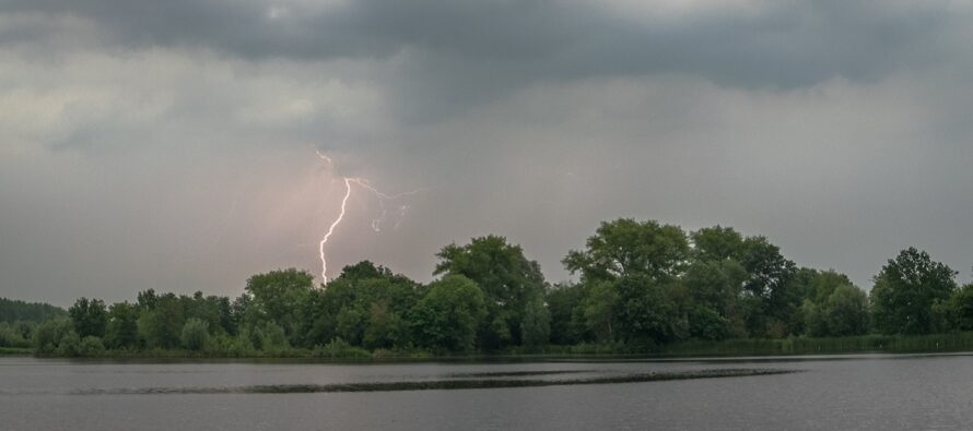
Discussion: This article is a bummer to write as I had plans to play golf with my buddies tomorrow. But here we are. As I’ve been covering in the weekly and weekend outlooks, the entire Mid-Atlantic US – and most of the E US, are under a sea of lower geopotential heights. Upper-low after upper-low with an overall condensed and lower atmosphere. This setup is very conducive for producing precipitation and thunderstorms especially in the warmer months. Water vapor has less altitude to rise to condense into water droplets, release latent heat, and form thunderstorms. This renders our lower atmosphere more sensitive to any routine lifting mechanism (meso front, sea breeze front, vertical sheer roll, a surface low, etc.) with regard to producing rain and storms. This setup should stay around for at least 10 more days and could finally deliver some much-needed rain to the region despite our hopes and dreams for outdoor activities. So for the long-range heads up, we’re looking at a wetter pattern beginning this weekend. It will not rain that entire period. Instead, it looks like a few hits from synoptic systems a few days apart. One of the hits could come from tropical cyclone remnants tracking up the coast from the SE US area. We have some time to figure it out.
As a more immediate expectation, we have a surface low expected to form over Delmarva/SNJ sometime Friday morning before tracking up the NJ coast Friday afternoon. At the very least this should bring periods of moderate, possibly heavy, rainfall to most of New Jersey between late-morning and early-evening hours of tomorrow (Friday). Flash flooding is a possibility for areas of poor drainage and dry run-off environments. Thunderstorms, however, are also very possible giving the proximity and lifting mechanism of the surface low. This increases the chances for areas of higher wind gusts (locally to the storm areas) and also hail (given the colder upper-levels now closer to the surface with the lower heights).
What we don’t have in tomorrow’s setup is a lot of diurnal instability. There will be a lot of clouds around which will prevent the sun from heating the surface under the colder air aloft. But we do have adequate wind sheer and lifting, With that said, I do not expect frequent lightning. Some but not frequent. Shear storms are more of an embedded boomer type event within heavy rainfall rather than a frequent light show that everyone sees well in advance of the approaching thunder cell(s). SNJ seems a little more favored for thunderstorm dynamics than NNJ. So my gut feel is moderate-to-heavy rainfall for the entire state with a little more boomer action happening in SNJ than NNJ. The action should approach WNJ by noon tomorrow (Friday) and clear ENJ by 8pm. Saturday and Sunday look much drier but could feature more clouds than sun. Sunday looks the driest. I will cover more in the weekend outlook tomorrow.
In English: Expect rain and thunderstorms to push through New Jersey tomorrow (Friday) afternoon-evening. Should approach WNJ around noon and clear ENJ by 8pm. Moderate-to-heavy rainfall with light-to-moderate winds is the highest confidence forecast. A lesser, but good, probability of thunderstorms exists with the ability to produce damaging wind gusts and hail. Should clear offshore by Friday night with maybe some remnant showers Saturday morning/afternoon. Saturday evening through all of Sunday (Father’s Day) then looks dry. Full weekend outlook tomorrow. For now, have a plan for rain/storms tomorrow afternoon-evening. Be safe! JC
Premium Services
KABOOM Club offers inside info forecast discussion, your questions answered, and early storm impact maps (ahead of the public). At 99 cents per month, it’s an extremely feasible way to show support.
My Pocket Meteorologist (MPM), in partnership with EPAWA Weather Consulting, offers professional/commercial interests, whose businesses depend on outdoor weather conditions (snow plowing, landscaping, construction, etc.), with hyper-local text message alerts/forecasts and access to the MPM premium forum—the most comprehensive and technical forecast discussion available for PA and NJ.
Jonathan Carr (JC) is the founder and sole operator of Weather NJ, New Jersey’s largest independent weather reporting agency. Since 2010, Jonathan has provided weather safety discussion and forecasting services for New Jersey and surrounding areas through the web and social media. Originally branded as Severe NJ Weather (before 2014), Weather NJ is proud to bring you accurate and responsible forecast discussion ahead of high-stakes weather scenarios that impact this great garden state of ours. All Weather. All New Jersey.™ Be safe! JC


LOCAL FORECAST | INTERACTIVE RADAR | LATEST NJ WEATHER ALERTS | WEDDING FORECAST| PRIVACY POLICY
© Copyright 2026 Weather NJ LLC. All Rights Reserved.
Some information that can be found on our website is provided by a private weather station and is not an officially recognized station for weather reporting. Though we always strive to achieve accurate reporting for our own use, it is important that you do NOT depend on the data provided here for any purpose.
