


Much Needed Rainfall on the Way

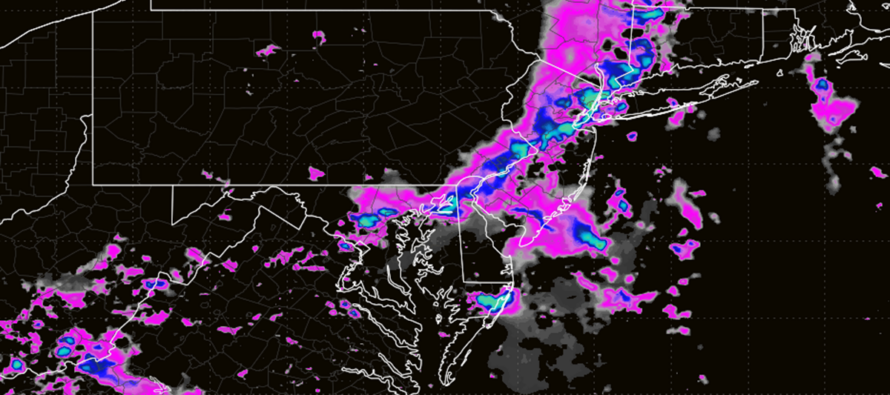
Discussion: Some much needed New Jersey rainfall is looking promising for the next few days, especially Tuesday PM into Wednesday AM. For the last few months, most rainfall has occurred from frontal systems and training thunderstorms. This opportunity is more of a synoptic-scale opportunity, what you sometimes hear referred to as a synoptic rainstorm.
The dynamics of this system feature an Upper Low (UL) that will break off from a trough in Canada and form just behind a current UL over the Mid-Atlantic US. The UL of interest will close off and spend most of its lifecycle tracking from the E Great Lakes to about the tip of Long Island between tonight (Monday night) and early Thursday morning. Beneath the UL will be a surface low that originated further to the W than the E Great Lakes but intends to track across the Great Lakes, along the N PA/S NY state border towards the NYC/NNJ area. On Tuesday evening, the surface low could be yanked back towards the UL via capture. This mechanism is something we track when snowstorms are happening in the winter, only it will occur over NY/PA instead of just off Delmarva/OBX. With that said, this is not a nor’easter. I don’t know if some pro sources are just plain wrong (unlikely) or looking for the additional traffic from having nor’easter in post/article titles (probably). A nor’easter needs to stall or retrograde (capture) off Delmarva/OBX to place NJ in a 6-12+ hour period of strong NE winds (on the NW side of the low). With this system, most NJ impacts will be from action on the E, SE or S side of the low, not the NW side of the low. But regardless of not being a nor’easter, we still have an interesting low track that can bring significant rainfall and embedded thunderstorms to the region.
Today (Monday) kicks off this synoptic system with just isolated-to-scattered thunderstorms mainly occurring anytime from now through midnight. Because there are no lows or frontal boundaries nearby, this evening’s activity features very low wind shear values. Wind shear is required to sustain/advance a thunderstorm by double helixing updrafts and downdrafts around each other. This prevents the downdraft from choking out the updraft and otherwise fizzling out shortly after thunder cell formation. Again, tonight we don’t have the wind shear. But we do have a very moist environment where the slightest lifting (even a weak surface trough) can form a thunder cell. And in this environment, such storm cells could dump impressive downpours and feature frequent lightning. But without the wind shear, severe wind potential is mitigated as is a slow tracking and sustaining thunderstorm. These are called air mass thunderstorms. The rise, become a storm, and without wind shear, fall right back down on the vertical column of lifting. They sometimes emit outflow boundaries during their collapse that can act as meso-fronts to create neighboring thunder cells that then do the same thing. If you watch this on radar, it looks like stationary storms that pulse instead of track. So that’s what I am expecting tonight.
Tuesday becomes more interesting as the UL and surface low approach closer. Then you will have an establishing lower-level jet our of the S conflicting with the cyclonic flow around the surface low…almost like what remnants of tropical storm do to our areas…you have differing wind directions and speed at various altitudes which is known as shear. SO we’ll have to watch for any potential wind threats Tuesday night into Wednesday morning. As far as rain goes, we should see an initial wave Tuesday morning a lull from late-morning into afternoon and then the main rain/stormfront event Tuesday PM into Wednesday morning. This is when inches of rainfall could occur. Some short range models are going wild with 10+ inch amounts suggested. The global operational models are suggesting more of a widespread 2-3 inch event. My recommendation is to go with the widespread expectation of about 2-3 inches of rain but allow isolated instances of more should any cells train or become stationary.
Wednesday looks like a transitional day back to improvement. Most rain should clear out to sea by 3am Wednesday morning. The cold front to follow this system as it heads out to sea could possibly produce some pop-ups Wednesday PM but right now that looks minimal/very isolated.
Thursday and Friday should place NJ on the W or SW side of the low which would mean N or NW winds and clouds/sprinkles/gloomy conditions with the sun maybe poking through at times.
In English: Isolated-to-scattered (not everyone sees) showers and thunderstorms are possible from now through this evening/overnight. They should be small and near stationary with rain downpours and lightning very possible but a lower possibility of damaging winds. On Tuesday, there should be an early morning wave of rain/storms and then increased rain/storm activity for all PM hours (possible lull late-morning to early-afternoon). Tuesday afternoon-night should produce the most rainfall of the entire system which should clear out early Wednesday morning leaving just the chance for some isolated pop-ups Wednesday afternoon. Thursday and Friday could be breezy and gloomy (light rain on and off) as the system takes its time to fully clear out. Saturday and Sunday look more settled from this range. It’s a week of much needed rainfall with Tuesday night the rainiest. Be safe! JC
Premium Services
KABOOM Club offers an ad-free environment, inside info (Above and Beyond) forecast discussion, your questions prioritized, and early storm impact maps and video releases (ahead of the public). At $1.99 per month, it’s an extremely feasible way to show additional support for Weather NJ and you can turn it on and off for however many months you wish. Think of it as a tip jar with perks. Available onFacebook or Patreon.
My Pocket Meteorologist (MPM), in partnership with EPAWA Weather Consulting, offers professional/commercial interests, whose businesses depend on outdoor weather conditions (snow plowing, landscaping, construction, etc.), with hyper-local text message alerts/forecasts from real meteorologists and access to the MPM premium forum—the most comprehensive and technical forecast discussion available for PA and NJ commercial interests.
KABOOM Shop is live if you want some KABOOM or Weather NJ Merch!

Jonathan Carr (JC) is the founder and sole operator of Weather NJ, New Jersey’s largest independent weather reporting agency. Since 2010, Jonathan has provided weather safety discussion and forecasting services for New Jersey and surrounding areas through the web and social media. Originally branded as Severe NJ Weather (before 2014), Weather NJ is proud to bring you accurate and responsible forecast discussion ahead of high-stakes weather scenarios that impact this great garden state of ours. All Weather. All New Jersey.™ Be safe! JC



LOCAL FORECAST | INTERACTIVE RADAR | LATEST NJ WEATHER ALERTS | WEDDING FORECAST| PRIVACY POLICY
© Copyright 2026 Weather NJ LLC. All Rights Reserved.
Some information that can be found on our website is provided by a private weather station and is not an officially recognized station for weather reporting. Though we always strive to achieve accurate reporting for our own use, it is important that you do NOT depend on the data provided here for any purpose.

