

Natural Air Conditioning Arrives Tonight

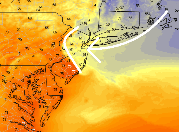
Discussion: Not much to update about today. It’s a hot one. But starting at around 8pm tonight, a Back Door Cold Front (BDCF) will advance into NJ from the E/NE. We can thank the anti-cyclonic nature (clockwise flow) of high pressure located just N of Maine for this. The S side of the high will provide the cooler E/NE flow and it will arrive in NENJ first. Between about 8pm tonight and 8am tomorrow (Wednesday) morning, the BDCF will reach it’s extent inland which will include most of NJ. Here is a model snapshot of expected surface temperatures just after midnight tonight. You can make out the BDCF:
It should feel, misty, and unsettled once behind the front through Wednesday morning. Wednesday then looks pretty good (warmer and improvement) during the day (late-morning through afternoon/early-evening) but then a traditional cold front will push through Wednesday night into Thursday morning from NW to SE. As of right now the front looks mostly dry with maybe some pop-up showers and storms along. But that should all clear out for an alright Thursday (daytime).
A low pressure disturbance should then track through NJ from W to E between late Thursday night and Friday morning. This looks more like synoptic rain rather than meso thunderstorms but let’s allow some embedded t-storms just in case since we do have the lifting trigger of the low itself. Once this clears (by 9am Friday), the entire weekend then looks great with an area of high pressure in control through at least Sunday night.
Early next week we might see a tropical system passing well offshore. It is currently expected to miss NJ with primary impacts (rain, wind, coastal flooding, etc.) but could enhance surf and rip currents along the east coast next week including all NJ beaches. As of now, the tropical system forms near the Yucutan Peninsula this Friday, crosses Florida (from SW to NE), and then veers out to sea S of OBX. Just something to casually monitor.
In English: The rest of today and this evening will be hot/warm as expected but a back door cold front off the ocean should provide relief starting tonight for NENJ (by daybreak tomorrow for the rest of Nj). Wednesday looks good during the day (warm and clear). Wednesday night into Thursday morning a little unsettled (iso/scattered showers/storms). Thursday daytime also looks good (warm and clear). Thursday night into Friday morning then looks rainy and breezy. Then this weekend is looking spectacular under a dome of high pressure. Everyone have a great rest of your Monday as we close out the month of May. Be safe! JC
Premium Services
KABOOM Club offers inside info forecast discussion, your questions answered, and early storm impact maps (ahead of the public). At a buck per month, it’s an extremely feasible way to show support for JC.
My Pocket Meteorologist (MPM), in partnership with EPAWA Weather Consulting, offers professional/commercial interests, whose businesses depend on outdoor weather conditions (snow plowing, landscaping, construction, etc.), with hyper-local text message alerts/forecasts and access to the MPM premium forum—the most comprehensive and technical forecast discussion available for PA and NJ.
Jonathan Carr (JC) is the founder and sole operator of Weather NJ, New Jersey’s largest independent weather reporting agency. Since 2010, Jonathan has provided weather safety discussion and forecasting services for New Jersey and surrounding areas through the web and social media. Originally branded as Severe NJ Weather (before 2014), Weather NJ is proud to bring you accurate and responsible forecast discussion ahead of high-stakes weather scenarios that impact this great garden state of ours. All Weather. All New Jersey.™ Be safe! JC


LOCAL FORECAST | INTERACTIVE RADAR | LATEST NJ WEATHER ALERTS | WEDDING FORECAST| PRIVACY POLICY
© Copyright 2026 Weather NJ LLC. All Rights Reserved.
Some information that can be found on our website is provided by a private weather station and is not an officially recognized station for weather reporting. Though we always strive to achieve accurate reporting for our own use, it is important that you do NOT depend on the data provided here for any purpose.
