

New Jersey Weekend Snowstorm Possible
Discussion: On Friday the 13th, the signal for this weekend was identified from specific teleconnection behavior analysis, specifically the point at which the negative NAO crosses into positive and a transient spike in the PNA/dip of the EPO. This traditionally sets up at least a temporary building ridge for the W US and a storm trough for the E US beneath a temporary block. Couple that with the coldest ocean temps of the year and general February climatology, and we came to the storm signal for a New Jersey snowstorm this weekend.
Upper Level Snowstorm Analysis
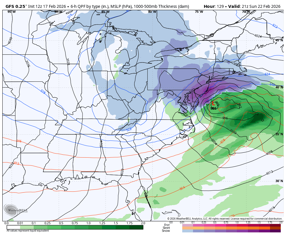
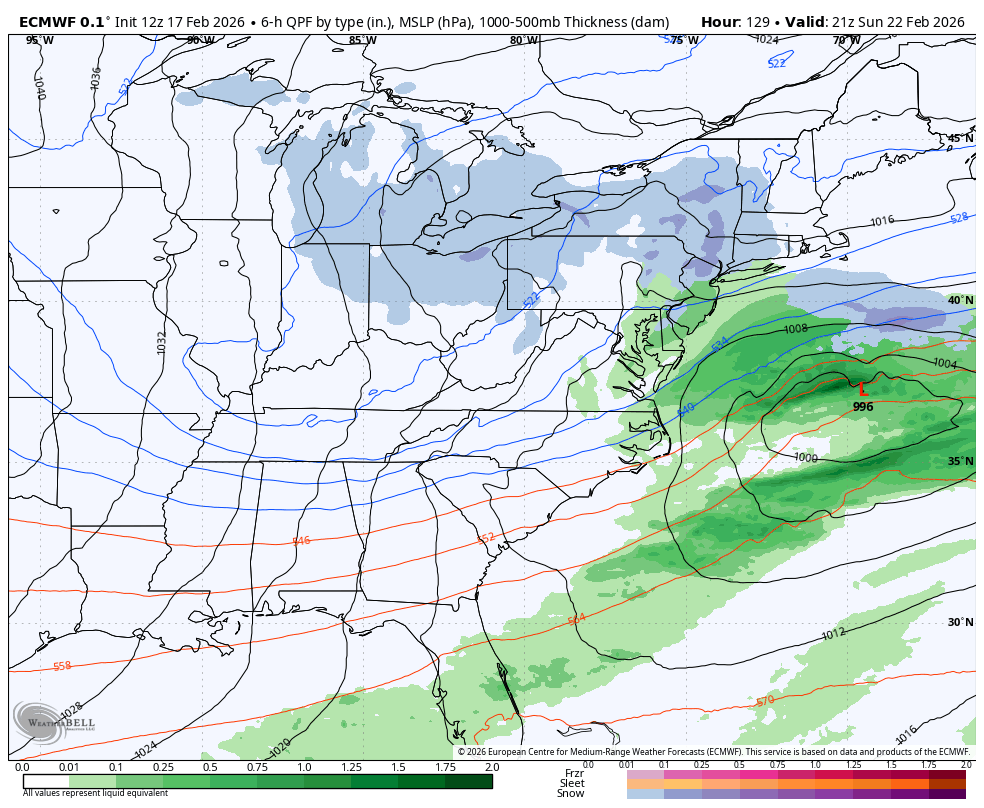
The numerical modeling systems are just starting to see this. It was first sniffed out by the GFS overnight the other night but other model sources have come on board (Canadian, UK, GFS AI, Euro AI, etc.). The Euro and GFS AI versions are dropping absolute nukes of a New Jersey weekend snowstorm. The Euro operational is still suggesting the southern stream energy being too progressive and not wrapping into the trough. This allows a weaker low to get too far ahead of the trough and only cause a partial interaction (scattered snow/rain showers instead of a storm). There is also strong support from the GFS, Canadian and European ensembles for the system. For now, the Euro operational (op) remains one possible outcome but currently on its own. Let’s look at the upper-level setup now modeled as expected after the teleconnection analysis.
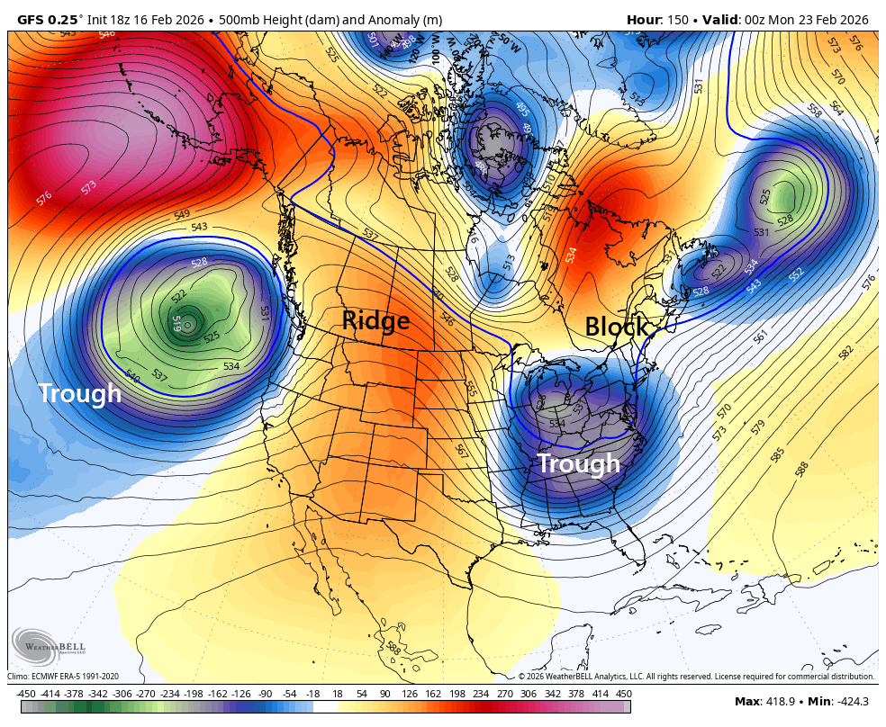
You see the temporary ridge in the W US with the storm trough ahead of it in the E US. You also see a block created by the UL near 50N/50W and the ridge just to its W in E Canada. That ridge and UL will provide upper steering currents towards the storm trough. It’s not a slam dunk prolonged ridge block over Greenland so it’s only temporary. But that also means it has to time with it. In either case, it’s enough block to at least slow the system down during its intensification and pull towards the UL/trough.
Lower Level Snowstorm Analysis
The actual surface low would then spawn somewhere in the SE US, track over OBX and curve up towards the 40N/70W benchmark. If the trough UL tugs the surface coastal low towards the coast, then its game on KABOOM blizz (first image of current GFS solution). If the southern stream energy is more progressive and phases in late, then the surface low will be late to spawn and not tuck in. In this case there would not be a New Jersey weekend snowstorm. This would be the partial interaction instead of full interaction (second image of current Euro solution). Notice the GFS has a 986mb tucked closer to the coast while the Euro has a 996mb further offshore:
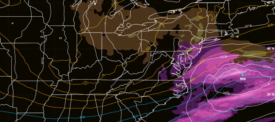
So having this upper-level setup modeled, on multiple models, for Sunday is a step towards the storm system happening for NJ and much of the N Mid-Atlantic US/Coastal NE. But we are still 5 days out which is a lot of time for models to see something they aren’t yet seeing. I would expect changes, hits, misses, and everything between for the next few days…solutions like the GFS, Euro or possibly even an earlier phase solution that brings rain into SENJ while 95 and NW KABOOM. It’s still early but this is as deep of a dive as I can take right now into the idea of a New Jersey weekend snowstorm. We’re probably looking at a storm vs no storm decision Thursday at the earliest with maps not until Friday. Again, that’s if the signal doesn’t drop off of data guidance in the next 48 hours. You and I all know we’ve seen it before. I intentionally posted the Euro storm image as the top cover image as a reminder of the less climactic scenario possible. It’s easy to get excited.
New Jersey Weekend Snowstorm Summary
But in general, support for a New Jersey weekend snowstorm is building from the current 5-day out mark and this needs to be watched. Between now and then, the milder temperatures should continue melting remaining snow pack. A little bit of rain Wednesday night into Thursday. Then rain again Friday (possible wintry mix for NNJ elevations). A break Saturday and then possibly the snowstorm Sunday into Monday. Current timing seems like an all day Sunday into some of Monday kind of thing but at 5 days away, expect that to rock back and forth between Sunday and Monday a bit.
In English: We have a few days of milder temperatures. Light rain possible Wed night into Thurs. Some more rain likely Friday (wintry mix possible for NNJ elevations). A break Saturday, a temperature drop into Sunday morning, then a possible snowstorm Sunday into Monday with moderate to major potential. We’re 5 days away now and just starting to take the signal seriously. This article likely starts daily articles heading in as well as videos in the evening so long as it doesn’t drop off. Because if it doesn’t, we’re looking at a KABOOM. And this would not be a light wind snow event, especially for the coast. Best to leave options open for now especially with a phase involved. At this point, the range of possibilities for Sun-Mon are anything from light snow/rain showers to a major snowstorm. Talk about your plan (groceries, batteries, gas for generators, etc.) between now and Thursday. Be ready to execute plan Thursday PM or Friday AM if potential is status quo. Right now, I give the New Jersey weekend snowstorm idea a 30% chance. Be safe! JC
Premium Services
KABOOM Club offers an ad-free environment, inside info (Above and Beyond) forecast discussion, your questions prioritized, and early storm impact maps and video releases (ahead of the public). At $1.99 per month, it’s an extremely feasible way to show additional support for Weather NJ and you can turn it on and off for however many months you wish. Think of it as a tip jar with perks. Available onFacebook or Patreon.
My Pocket Meteorologist (MPM), in partnership with EPAWA Weather Consulting, offers professional/commercial interests, whose businesses depend on outdoor weather conditions (snow plowing, landscaping, construction, etc.), with hyper-local text message alerts/forecasts from real meteorologists and access to the MPM premium forum—the most comprehensive and technical forecast discussion available for PA and NJ commercial interests.
KABOOM Shop is live if you want some KABOOM or Weather NJ Merch!
Sign up for ZoneWatch Radar and get 10% off
Jonathan Carr (JC) is the founder and sole operator of Weather NJ, New Jersey’s largest independent weather reporting agency. Since 2010, Jonathan has provided weather safety discussion and forecasting services for New Jersey and surrounding areas through the web and social media. Originally branded as Severe NJ Weather (before 2014), Weather NJ is proud to bring you accurate and responsible forecast discussion ahead of high-stakes weather scenarios that impact this great garden state of ours. All Weather. All New Jersey.™ Be safe! JC


LOCAL FORECAST | INTERACTIVE RADAR | LATEST NJ WEATHER ALERTS | WEDDING FORECAST| PRIVACY POLICY
© Copyright 2026 Weather NJ LLC. All Rights Reserved.
Some information that can be found on our website is provided by a private weather station and is not an officially recognized station for weather reporting. Though we always strive to achieve accurate reporting for our own use, it is important that you do NOT depend on the data provided here for any purpose.
