

NJ Eyeing Up an Arctic Snowstorm this Weekend
Discussion: This will be a very detailed and in-depth weather discussion about two things: The approaching prolonged cold pattern and the weekend snowstorm potential. The In English section will also lay out a schedule of programming for this week as far as what updates to expect and when. High stakes weather situations simply call for more so here we go.
The first and foremost aspect to all of this is safety. Whatever preparations you typically make for long periods of cold weather, and possibly a major snowstorm, should be made this week. Each of you have different situations with your housing and work, but the main ideas that typically apply to all are: you should make sure you have adequate resources to stay warm, have food and supplies, and safeguard anything that could go wrong with extreme cold such as pipes bursting, etc. And you should start thinking about being snowed in this weekend into next week if the snowstorm comes into fruition. While the snowstorm has lesser confidence than the prolonged cold pattern, if it comes together we could be looking at the historical category of a snowstorm.
Long Range Pattern Analysis – Prolonged Cold
There’s no way to sugarcoat it. We’re going into the Arctic after this Friday. We’ll get a small taste of it tomorrow (Tuesday) but we moderate a little from Wednesday through Thursday into Friday morning/daytime. Once the front drops through from N to S Friday night into Saturday, we’ll then be into the Arctic for quite some time. We’ve seen similar cold patterns to this in January 2018 (below freezing for 18 days) and the Polar Vortex Outbreak of Winter 2013-2014. Those who were alive for the 60s and 70s talk about how this kind of cold used to be common and now few and far between. Well this incoming cold will be a case of the few.
The El Nino Southern Oscillation (ENSO) cycle, which measures sea surface temperature anomalies along the eastern equatorial Pacific, is indicating the death of La Nina. We’re expecting La Nina to transition to a neutral ENSO phase in February and then move well into El Nino by spring. The only thing I want to mention about such a transition is that winters featuring a Nina into Nino change have known to be wild. Winter 2013-2014 was a similar setup.
The Madden Julian Oscillation (MJO) measures the greatest forcing (lifting) along the equator in the western equatorial Pacific ranging from Indonesia to the International Date Line. Right now we are in Phase 6 moving into phase 7 and should be in phase 8 by the end of January. Phase 8, 1 and 2 are good patterns for snow lovers because that specific area of lifting in the W equatorial typically translates downstream to a trough pattern for the E US capable of supporting snow storms.
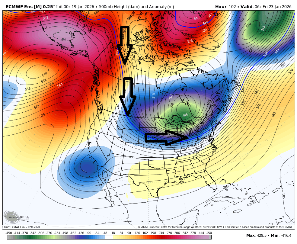
The Easter Pacific Oscillation (EPO) and Pacific North American (PNA) are teleconnections (interconnected global patterns) that measure trough vs ridge in the E Pacific/W US. This week they will be in a -EPO and +PNA configuration which means a large ridge covering the Alaska/W US areas. The jet stream flows up and around this ridge and then downwards into the central US. In addition to having a -EPO/+PNA this week/weekend, we will have a cyclonic Tropospheric Polar Vortex (TPV) lobe near the Hudson Bay rotating counter-clockwise. The W side of this lobe will also force air southward from the Arctic regions into the central US. This combination produces cross polar flow where the coldest air of the N hemisphere is transported from the Siberian region, across the N Pole and into the US. This will be the primary mechanism for transporting the upcoming cold pattern into the E US. This upper-level image from the European (Euro) model illustrates such:
The North American Oscillation (NAO) is a teleconnection measurement of whether there is a ridge vs trough over Greenland. A +NAO means there is a trough over Greenland which rips storms away from the E US quickly and allows cold to escape the US. A -NAO (ridge over Greenland) slows down snowstorms for greater impact on the E US but also prevents cold from retreating into the Arctic. In the case of this weekend, we’ll have a -NAO and it should do the latter. But the -NAO looks to persist through the rest of January into February, further reinforcing our colder pattern and preventing any storms that form from moving quickly out of the area.
The Arctic Oscillation (AO) is a teleconnection measurement of how tight or loose the coldest air of the N Hemisphere circulates around the N Pole. A +AO means a tight circulation which prevents the colder Arctic air from spilling downwards to lower latitudes (such as the US). This week/weekend, we’ll have a -AO which means the circulation is weak, allowing the spill of the Arctic air southwards into the US latitudes. Think of tressening a piece of meat before braising. If you wrap it with string, it will stay together during the braise (+AO). If you don’t wrap it, it will fall apart in the braising liquid (-AO).
The result of the above-described global patterns and teleconnections will be well below average temps to close out January and below-average temps for much of February (transient warmups between prolonged cold periods – the continued theme of this winter).
The arrival of prolonged colder patterns are typically welcomed by larger snow events due to the general concept of cold sliding under warmth and generating a ramp lifting effect. Surface moisture is lifted to a level of condensation and, in a cold environment, turns on the snow making machine. Typically colder patterns begin and end with some kind of synoptic storm. The beginners are the higher snow impact storms and the enders typically produce snow to ice to rain situations. This weekend, we’re looking at a beginner.
Weekend Snowstorm Analysis
This weekend could be a monster snowstorm. I’ve dusted off the KABOOM profile icon just in case but not ready to use it yet. If it looks that way later this week then maybe a KABOOM warning will be issued. But right now there is just the potential not a hard call forecast for it. There are actually two snowstorm signals in the last third of January, per ensemble analysis: Jan 24-26 and Jan 28-30. I won’t even touch the Jan 28-30 signal outside of this mention. For now, we will focus on Jan 24-26 (this weekend).
Based on the analysis above of a pattern favorable for supporting a snowstorm this weekend, the ingredients are there for it. While the -NAO blocking will be establishing, it isn’t involved in slowing a powerful coastal low/storm down. That’s not the setup here. The -NAO influence for this weekend will be to reinforce the thermal gradient from drifting too far N. The thermal gradient is/will be the sharp transition, running from W to E, of warmer temps in the S US butting up against the cross polar flow influences spilling out of Canada. With the strong colder air expected, this thermal gradient could span as far S as Texas to the central Mid-Atlantic or even as far S as the SE US. On Wednesday (Jan 21) a lobe is expected to break off from the TPV over Hudson Bay and eject eastward, cutting off the blocking mechanism and creating a zonal flow wall as the original TPV lobe also drifts E. So, no meridional negative trough tilt or powerful coastal low. I suppose this is a silver lining for wind damage concerns as we will not be dealing with a strong storm low but rather a weak and flat low throwing overrunning moisture into the cold. This means a lesser chance of blizzard conditions being met despite the potential for large amounts of snow accumulation. The low will be weaker but will have an adequate tap to the SubTropical Jet (STJ) to hurl moisture northward into the Arctic air mass.
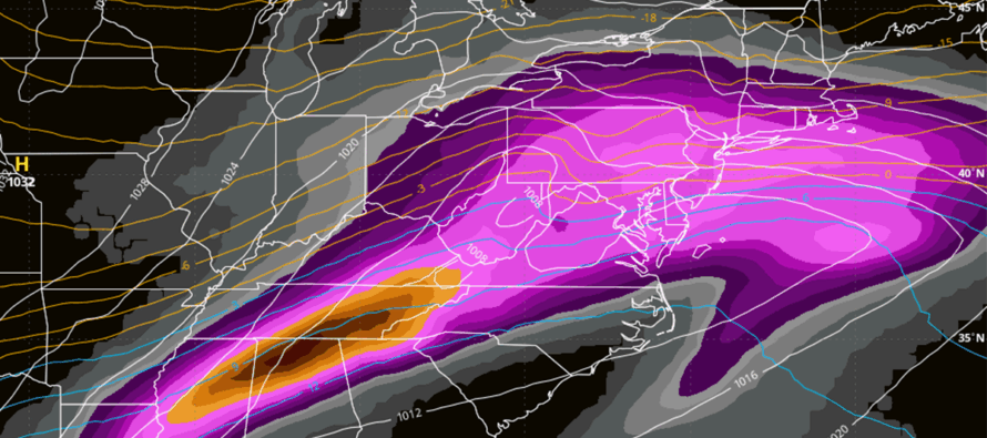
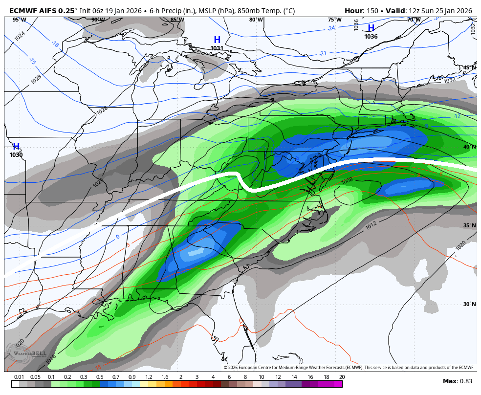
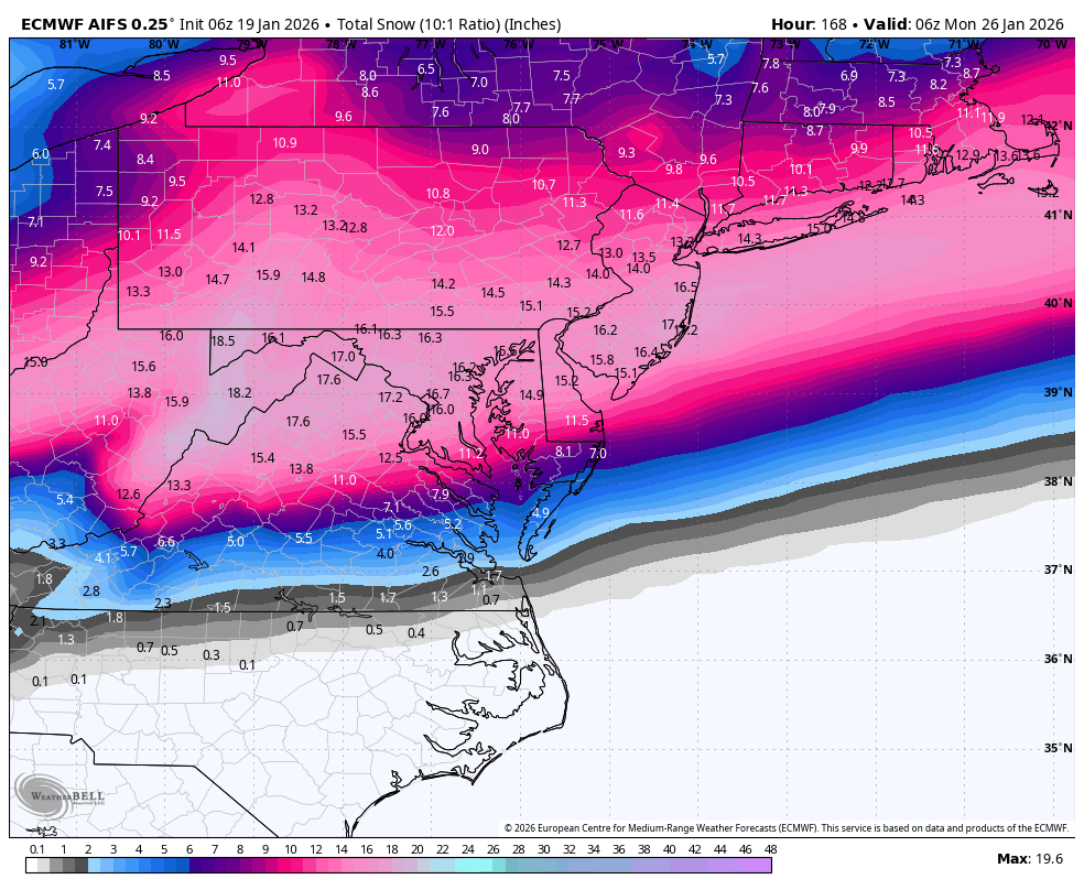
While I advise not driving yourself crazy with surface maps just yet, here are some examples of what could happen at the surface if the snowstorm comes to fruition this weekend. A key element to how far N the snow makes it will be the strength and position of an Arctic high pressure expected to pass over the Chicago area. The front side of this high will feature air moving N to S. If the high is weaker then the storm comes further N for more NJ impacts. If the high is stronger, it could push the storm S of NJ. The first images below, from the Euro AI, are examples of the high being weaker and in position to let the storm happen. Image one is the birds eye view of the system setup (looks like it belongs on Jupiter or something). Image two is a snow map of what is possible. And keep in mind, the snow map is at 10:1 snow ratios. With the caliber of cold involved, snow ratios could easily exceed 15:1 possibly 20:1 which means amounts could possibly be doubled. The white line I drew illustrates where the snow/rain line would likely set up:
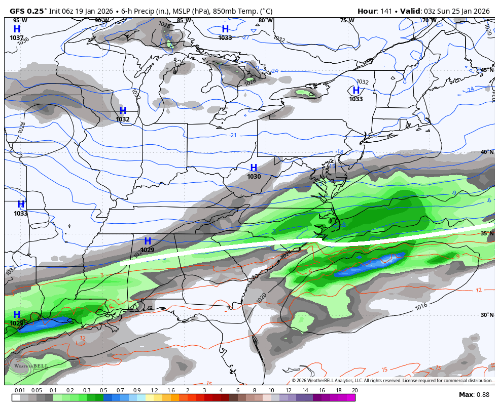
What could prevent the weekend storm from happening? The colder forces from the N (cross polar flow and front of Arctic Chicago high) could suppress the entire system to the S of NJ, allowing only maybe a SNJ graze. This is an entirely plausible solution and I do have some concerns about it happening. This image, from the GFS, shows an example of this:
Timing: From this range, it looks like first flakes to final flakes would be Saturday noon through Sunday night/Monday morning. This would mean a 12-18+ hour snowfall should the system hit like the first two images (Euro AI). If the system misses to the S of NJ, you’re obviously looking at a shorter time window for the SNJ graze to possibly happen, spanning from late Saturday night into maybe mid-day Sunday. I will adjust timing expectations throughout this week as the data evolves.
In English: This week looks dry until possible showtime this weekend. We’re going to get a taste of the incoming cold weather on Tuesday (tomorrow) as an appetizer high pressure brings down some colder Arctic air in a transient nature. Tuesday should reach a high range of 20-30 NNJ to SNJ with Monday night (tonight) and Tuesday night lows in the teens, maybe single digits for elevations. We then rebound and moderate for Wednesday through Thursday and into Friday (highs in 30s/40s) as the back side of that high brings milder air in from the S. The main cold front (running W to E) then settles in through NJ from N to S Friday night into Saturday and kicks off a prolonged period of well-below average temperatures that could last through the end of January (highs in teens/20s lows negative to single digits NNJ to SNJ). The cold pattern could last well into February though probably not as cold as the end of January. This prolonged Arctic cold expectation has higher confidence. This Saturday, through Sunday and possibly into Monday could feature the largest snowstorm of the season if it comes together (not as confident as the cold pattern). All pros and cons are detailed in the above discussion. But if you are a numbers person, the chances of it happening have increased from yesterday (30% chance) to today (50% chance) IMO, especially now that we are 5 days away from first flakes. I will be tracking this closely this week and updating accordingly. KABOOM Club members (link to subscribe below) will get everything first in an ad-free environment with questions prioritized for answering over public questions (there’s simply too many people) as well as daily model analysis. For the baseball analogy: We are in the bottom of the 4th inning of winter. We are up a few runs (much of NJ above average snowfall for this time of year), the bases are loaded (large snowstorm potential) and Aaron Judge is stepping up to bat. He could knock it out of the park. He could strike out. Since this week is building towards such high-stakes potential, here is the programming schedule to expect, assuming the snowstorm expectation holds:
Monday-Wednesday AM (Jan 19-21): This article. Serious model analysis and tracking but no forecast yet with a goal to observe a converging consensus by Wednesday afternoon. Daily model analysis in KABOOM Club subscription areas.
Wednesday: Storm Go vs No Go decision (pending model consensus – might need until Thursday) with a probabilistic approach of what to expect (no snow amounts but an idea of areas to see the biggest impact). 5pm article (1pm for KABOOM Club) and evening video.
Thursday: Anticipated first call forecast. 5pm snow map article (1pm for KABOOM Club) and later evening video.
Friday: Anticipated updated call forecast. 5pm snow map article (1pm for KABOOM Club) and later evening video.
Saturday Morning: Final call snow forecast and snow map adjustments if needed.
Saturday Afternoon/Evening: Live observation videos/reels begin.
Sunday into Monday Morning: Live observation videos/reels continue accordingly.
I got a good rest last night but I just rolled up my sleeves for how this week could possibly go. Have a great rest of your Martin Luthor King Jr. Monday and please be safe! JC
Premium Services
KABOOM Club offers an ad-free environment, inside info (Above and Beyond) forecast discussion, your questions prioritized, and early storm impact maps and video releases (ahead of the public). At $1.99 per month, it’s an extremely feasible way to show additional support for Weather NJ and you can turn it on and off for however many months you wish. Think of it as a tip jar with perks. Available onFacebook or Patreon.
My Pocket Meteorologist (MPM), in partnership with EPAWA Weather Consulting, offers professional/commercial interests, whose businesses depend on outdoor weather conditions (snow plowing, landscaping, construction, etc.), with hyper-local text message alerts/forecasts from real meteorologists and access to the MPM premium forum—the most comprehensive and technical forecast discussion available for PA and NJ commercial interests.
KABOOM Shop is live if you want some KABOOM or Weather NJ Merch!
Sign up for ZoneWatch Radar and get 10% off
Jonathan Carr (JC) is the founder and sole operator of Weather NJ, New Jersey’s largest independent weather reporting agency. Since 2010, Jonathan has provided weather safety discussion and forecasting services for New Jersey and surrounding areas through the web and social media. Originally branded as Severe NJ Weather (before 2014), Weather NJ is proud to bring you accurate and responsible forecast discussion ahead of high-stakes weather scenarios that impact this great garden state of ours. All Weather. All New Jersey.™ Be safe! JC


LOCAL FORECAST | INTERACTIVE RADAR | LATEST NJ WEATHER ALERTS | WEDDING FORECAST| PRIVACY POLICY
© Copyright 2026 Weather NJ LLC. All Rights Reserved.
Some information that can be found on our website is provided by a private weather station and is not an officially recognized station for weather reporting. Though we always strive to achieve accurate reporting for our own use, it is important that you do NOT depend on the data provided here for any purpose.
