

NJ Eyes Up Another Major Snowstorm this Weekend
Discussion: Once again, we will remain in article format for this week as there’s a lot going on, simply not able to be captured by a single “Weekly Outlook.” This article today will provide a synoptic storm re-cap of this past weekend’s Arctic snow storm, what to expect this week, and then a look at the weekend as NJ eyes up another major snowstorm this weekend.
Storm Recap
About two weeks ago, teleconnections indicated a large ridge spanning across Alaska into the NW US (a negative phase of the Eastern Pacific Oscillation (EPO) and positive phase of the Pacific North American (PNA)) to set up for this past week. Then about a week ago, models were indicating that an Upper Low (UL) off California (beneath the ridge) was going to interact with a ShortWave (SW) rounding a polar trough carved out by the Tropospheric Polar Vortex (TPV) centralized near the W side of the Hudson Bay. This gave great confidence to cross polar flow delivering a historic shot of cold air into the US from the N. That cold air spilled down as expected and saturated much of the central and eastern US with a sea of bitter cold, reinforced by a swath of high pressure. Two high pressures were larger and more distinguished synoptically since they featured region-wide anti-cyclonic flow around them, one over south-central Canada and another over SE Canada. While all of this was in place a week ago, there was weak interaction between the Baja UL and polar SW. This was resulting in a strung-out phase of the two and a snowstorm occurring much further S along the E coast with a miss to the S of NJ. Then hurricane hunter aircraft dropped dropsonde sensors into the Baja UL and guidance corrected significantly starting Tuesday-Wednesday. Guidance then showed that the polar SW and Baja UL phased better in the SW US, digging out a deeper overall trough. This in-turn raised heights downstream for the east coast. Instead of a flat singular weak wave traversing the thermal gradient across the SE US, a Miller-B situation was born where the wave found a weakness to track a primary low N into the TN valley/Western PA region to then spawn a secondary coastal low off OBX. The double barrel high situation across S Canada was met with a double barrel low Miller-B situation across the mid-US latitudes. This brought the storm northward, allowing subtropical moisture to funnel northward to about the I-80 corridor across NJ. Because it was so cold over NJ from the Arctic air, prior to the initial precip, the initial Gulf moisture produced significant-to-major snow and sleet accumulations for CNJ and SNJ. NNJ was able to see major snow accumulations due to the thermal gradient norther extent of the push. CNJ and SNJ saw all their snowfall early in the Sunday snowstorm (before the changeover) while NNJ saw their accumulation both morning and night with little-to-no changeover. The result is what NJ saw in yesterday’s snowstorm. Goodbye and good riddance, especially to the ice storm component. Onto this week.
Weekly Outlook
Now that the storm system has moved away and out to sea, the weakness found by the Miller-B primary has closed up and we’re back to Arctic air dominance. This will produce dangerously cold temperatures this week with Tuesday-Thursday being the coldest point. Wouldn’t be surprised to see temps dip below zero (yes below zero, not below freezing…below ZERO) for overnight lows. NWNJ will be the coldest and SENJ the least cold. But all areas will be shockingly cold. We begin to moderate a little on Friday and Saturday but still well below average. Today through Saturday looks dry and cold with afternoon highs still staying well below freezing. It’s the heart of the cold season folks and we’re in a cold winter.
NJ Eyes Up Another Major Snowstorm this Weekend
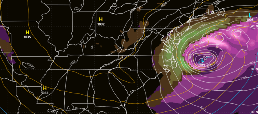
Now let’s talk about the potential NJ snowstorm this weekend anywhere from Saturday PM to Monday AM, the general storm signal period. From this range (5-6 days away), all three bigs (the global operationals – GFS, Canadian and Euro) suggest there’s going to be a powerful (deep mb) storm off the east coast this weekend. The storm system would be in the form of a Miller-A which is a singular surface low that forms in the Gulf, crosses the SE US, and tracks up the east coast offshore. This low is then influenced by the upper levels involving a phase and capture. The phase is what combines energy from the trough and southern energy branch into a single unit of energy in the central-east US, capable of supporting and capturing a powerful snowstorm/blizzard. The capture is how the phase pulls the surface low closer to the coast so that precipitation can make it off the ocean and onto NJ.
An early capture would pull the storm too far inland and produce a mix/rainstorm for NJ. A late capture would not pull the surface low enough and all significant/major precipitation would miss offshore (think the great blizzard bust of January 2015). But a perfectly timed phases and capture would send the surface coastal low track near the 40N/70W location known as “the Benchmark” and produce a major snowstorm/likely blizzard for NJ (think January 1996 or December 2010). So, it’s very much a thread the needle situation in timing. However, the pattern is more supportive for this to happen vs a non-supportive pattern. I am giving it a 30% of it happening at this point and will adjust that expectation accordingly each day. But regardless, NJ eyes up another major snowstorm this weekend. So all three bigs (GFS, Canadian and Euro) have the storm forming. There is good confidence of it forming and occurring. The key uncertainty is whether or not it will phase/capture early, just right or late. And I DO expect this to vary quite differently each run to run this week as we approach closer.
Model guidance has been all over this already. The Euro was captured perfectly last night but has missed OTS today. The Canadian was OTS last night but is captured perfectly today. The GFS was furthest OTS last night but is closer today. I showed the GFS on the above cover image to illustrate a solution that is totally possible/plausible…a hairline miss for most. I didn’t show the Canadian because it was too big a hit and many will cry that I’m hyping. Last night’s Euro would have broke the internet vs today’s Euro which is a clean miss out to sea. Expect a lot of that this week. Don’t drive yourself crazy run to run. Try to visualize a smoothing-out of all runs this week converging on a more consensual idea by about Thursday. It is important to re-emphasize that a capture/phase can surprise hours before a storm, even mid-storm. You should never fully trust it and expect that drastic changes can happen up the first flakes of the storm system. It’s going to be a long week as NJ eyes up another major snowstorm and I am already rolling up my sleeves. To sum it up, New Jersey is eyeing up another major snowstorm this weekend, but confidence still must build for a few days before any snow maps or forecasts can be made.
In English: It’s going to be a very cold week with temps below zero in some areas overnight (NWNJ elevations favored) and afternoon highs still staying well-below freezing (32F) statewide. The week looks dry and cold. Then NJ eyes up another major snowstorm this weekend from a coastal low capable of becoming a nor’easter. While this could bring more heavy snow to the state and region, it could also bring wind and coastal flooding concerns to the immediate coasts of ECNJ/SENJ/SNJ. As I did a week before yesterday’s storm system, here is a programming schedule assuming the status quo is kept, which right now has the storm gaining confidence. Just know that I could very well take this off the table should the signal drop off midweek:
- Monday (Jan 26): Monitoring Snowstorm Signal. Article (this one). No video tonight as I am still resting from recent Arctic snow/ice storm.
- Tuesday (Jan 27): Monitoring Snowstorm Signal. Article + Evening YouTube Video
- Wednesday (Jan 28): Serious Snowstorm Tracking Begins. Article + Evening YouTube Video
- Thursday (Jan 29): Serious Snowstorm Tracking Continues. Article with General Idea Map + Evening YouTube Video. KABOOM WATCH decision.
- Friday (Jan 30): First Call Snow Map with Expected Snow Amounts. Article + Evening YouTube Video
- Saturday (Jan 31): Updated Call Snow Map with Expected Snow Amounts. Article + Evening YouTube Video. KABOOM WARNING decision.
- Saturday Night (Jan 31) through Sunday (Feb 1), possibly into Monday (Feb 2): Realtime Snowstorm Tracking and Live Observation Content.
KABOOM Club members (see premium services below) will be privy to above and beyond daily model data analysis as well as my thoughts before they release to the public. Specific questions about the storm will be prioritized for answering in KABOOM Club as there are simply too many to answer in public comments. Have a great rest of Monday and please be safe! JC
Premium Services
KABOOM Club offers an ad-free environment, inside info (Above and Beyond) forecast discussion, your questions prioritized, and early storm impact maps and video releases (ahead of the public). At $1.99 per month, it’s an extremely feasible way to show additional support for Weather NJ and you can turn it on and off for however many months you wish. Think of it as a tip jar with perks. Available onFacebook or Patreon.
My Pocket Meteorologist (MPM), in partnership with EPAWA Weather Consulting, offers professional/commercial interests, whose businesses depend on outdoor weather conditions (snow plowing, landscaping, construction, etc.), with hyper-local text message alerts/forecasts from real meteorologists and access to the MPM premium forum—the most comprehensive and technical forecast discussion available for PA and NJ commercial interests.
KABOOM Shop is live if you want some KABOOM or Weather NJ Merch!
Sign up for ZoneWatch Radar and get 10% off
Jonathan Carr (JC) is the founder and sole operator of Weather NJ, New Jersey’s largest independent weather reporting agency. Since 2010, Jonathan has provided weather safety discussion and forecasting services for New Jersey and surrounding areas through the web and social media. Originally branded as Severe NJ Weather (before 2014), Weather NJ is proud to bring you accurate and responsible forecast discussion ahead of high-stakes weather scenarios that impact this great garden state of ours. All Weather. All New Jersey.™ Be safe! JC


LOCAL FORECAST | INTERACTIVE RADAR | LATEST NJ WEATHER ALERTS | WEDDING FORECAST| PRIVACY POLICY
© Copyright 2026 Weather NJ LLC. All Rights Reserved.
Some information that can be found on our website is provided by a private weather station and is not an officially recognized station for weather reporting. Though we always strive to achieve accurate reporting for our own use, it is important that you do NOT depend on the data provided here for any purpose.
