

NNJ Snowstorm Approaching!
Discussion: This will be the last forecast discussion article heading into this system. Tomorrow morning, I might post one more to open up live observations.
We’ve beaten this to death since Dec 31. It’s really just a weaker low that tracks across the U, favorably for some snow in the colder parts of NJ. It is not a coastal plain snowstorm. It is a piedmont and higher snowstorm. For the coastal plain, it’s a rain and wind event. For I-95 and areas just NW of I-95, it’s a rain/wet snow slop job.
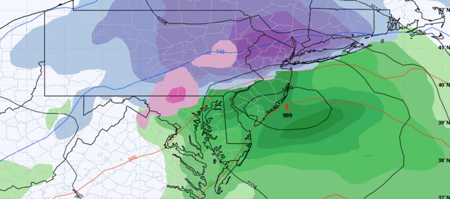
The only physics I’d like to point out are the interaction between the coastal low and some neighboring influences. When the coastal low gets over the Atlantic Ocean (S of Long Island), it is modeled to elongate from W to E instead of staying a more concentric low. The elongation is mostly due to the high just to the N (in SE Canada) but also due to the low reaching out to the W/NW towards other energy over the Great Lakes. This elongated counter-clockwise rotation around the low will then drive warm ocean air through CNJ/SNJ into SE PA. That is why such areas will see lower accumulations of snow in this event. They will be under a warm nose layer between 850-925mb. The elongation is a double-edged sword though. It also seals in the cold air to the N of it for not just NWNJ but some of NENJ too. So, what is taken from SEPA snow-wise is given to NENJ. This will be the main annoying mechanism that will roast out SNJ and most of CNJ during the event…while allowing NWNJ and some of NENJ/WCNJ to snow more away from 95.
Model guidance fluctuated some more yesterday and overnight. Some were hinting at a Cold Conveyor Belt (CCB) on the back-side of the system dragging out the precipitation into Sunday afternoon or possibly longer. That idea has lost support and instead we’re still looking at a primary impact of Saturday afternoon/evening through Sunday morning. Here’s our updated snow map for today which is not much different than yesterday’s first call.
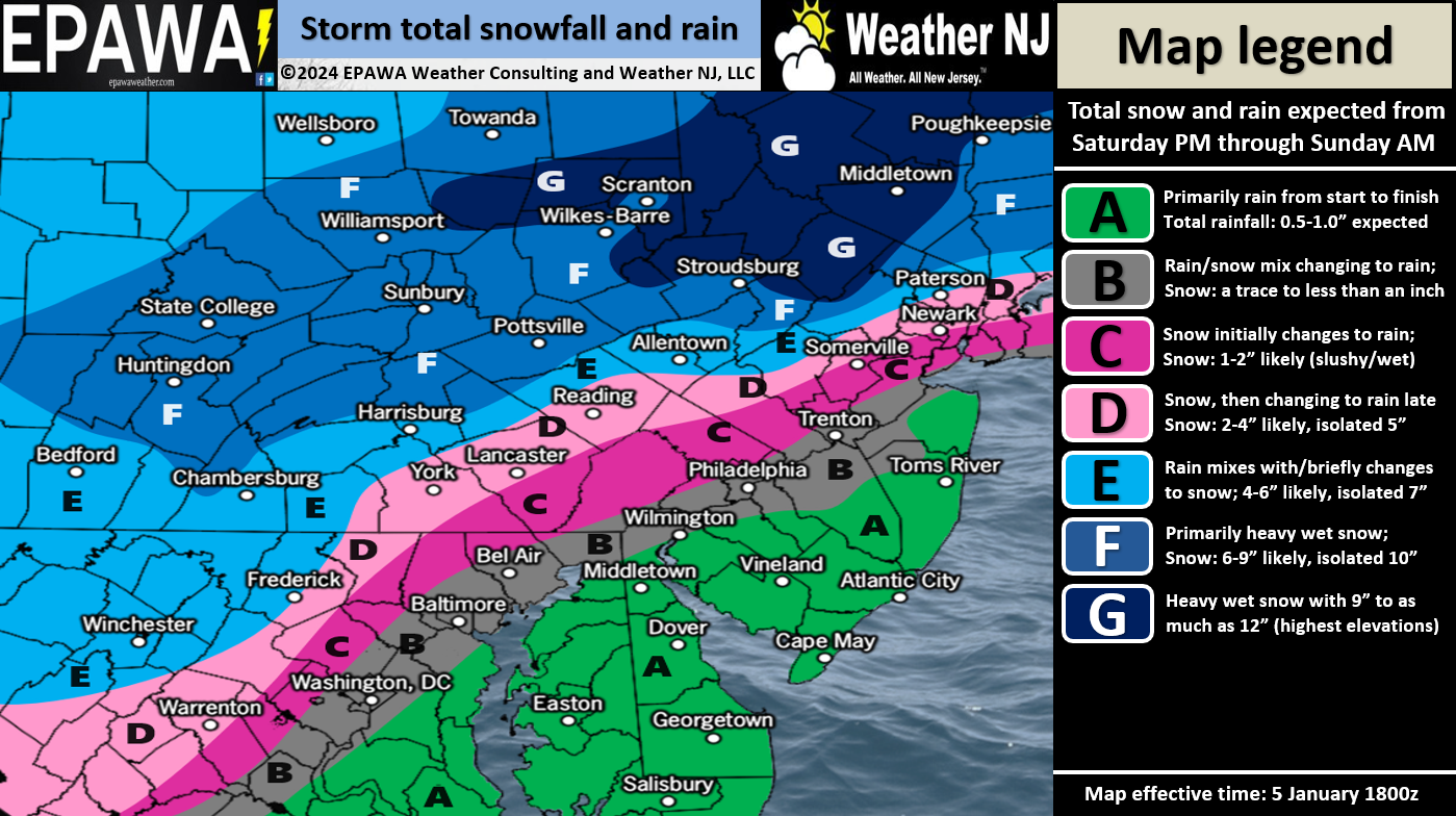
Zone A: All rain, with a general range of a half-inch to an inch of rain over course of the storm.
Zone B: Much like zone A but possibly starting as a mix of snow and rain before changing over to rain.
Zone C: This is more of a battleground zone and should see more snow up-front than zone B before switching to rain. 1-2 inches of wet slushy snow possible that will get knocked down a lot by the rain by Sunday morning.
Zone D: This is a major battleground zone which models have varied wildly on. At some point rain will likely make it up this far but 2-4 inches of snow could fall first. Sounds like a slushy mess.
Zone E: This zone is the highest we believe the snow/rain line will make it before the system tapers off Sunday morning. Therefore this zone should see 4-6 inches of snowfall before any rain kisses the zone.
Zone F: We believe this zone should see all snow. We’ve increased this area to a general expectation of 6-9 inches of snow with isolated locations possibly seeing 10 inches.
Zone G: This is the jackpot zone and we’ve extended it from Sussex only to now include some of N Warren, extreme N Morris, and some of extreme NW Passaic Counties. If anyone is going to KABOOM locally/isolated, it should be in this zone. My money would be on the High Point Monument area of Sussex County. But otherwise, we are going with a general 9-12 inches of snow for zone G.
Winds: Wind expectations have not changed. Expect region-wide (most of NJ) gusts in the 20-30mph range with the exception of the ECNJ/SENJ coasts where winds could gust 40mph+ off the ocean. Pretty run-of-mill for a coastal low.
Coastal Flooding: Theirs is still only one high tide of concern which happens about 3-5am Sunday morning up and down the Jersey coast. This high tide period is when the wind-driven storm surge should peak along with rainfall. We have a favorable lunar phase but I could still see at least minor coastal flooding Sunday AM.
Timing: First drops/flakes for SWNJ should happen any time after noon on Saturday but likely by 4pm. Precipitation will then spread NE into the rest of NJ by 7pm. Winds will start to build off the ocean at this time as well. The peak winds for coasties should occur between 7pm Saturday and 3am Sunday. From 3am Sunday and forward expect winds to switch to the NW and become less gusty than they were off the ocean. Winds should subside by Sunday afternoon/evening.
In English: A coastal storm will bring snow to NWNJ/NNJ, a mix to WCNJ, and all rain for ECNJ/SNJ between Saturday afternoon and Sunday morning with peak storm conditions occurring overnight (between 7pm Saturday night and 7am Sunday morning). This should allow for a nicer most of Sunday once the system clears and skies improve. Saturday should start cloudy and gradually deteriorate from late-morning through afternoon/evening. The above impact map addresses how much snow could fall for NWNJ/NNJ. Live observations will begin tomorrow morning. Be safe! JC
Premium Services
KABOOM Club offers inside info forecast discussion, your questions answered, and early storm impact maps (ahead of the public). At a buck per month, it’s an extremely feasible way to show support.
My Pocket Meteorologist (MPM), in partnership with EPAWA Weather Consulting, offers professional/commercial interests, whose businesses depend on outdoor weather conditions (snow plowing, landscaping, construction, etc.), with hyper-local text message alerts/forecasts and access to the MPM premium forum—the most comprehensive and technical forecast discussion available for PA and NJ.
Get your KABOOM Inside Out pajamas and more at the KABOOM shop!
Jonathan Carr (JC) is the founder and sole operator of Weather NJ, New Jersey’s largest independent weather reporting agency. Since 2010, Jonathan has provided weather safety discussion and forecasting services for New Jersey and surrounding areas through the web and social media. Originally branded as Severe NJ Weather (before 2014), Weather NJ is proud to bring you accurate and responsible forecast discussion ahead of high-stakes weather scenarios that impact this great garden state of ours. All Weather. All New Jersey.™ Be safe! JC


LOCAL FORECAST | INTERACTIVE RADAR | LATEST NJ WEATHER ALERTS | WEDDING FORECAST| PRIVACY POLICY
© Copyright 2026 Weather NJ LLC. All Rights Reserved.
Some information that can be found on our website is provided by a private weather station and is not an officially recognized station for weather reporting. Though we always strive to achieve accurate reporting for our own use, it is important that you do NOT depend on the data provided here for any purpose.
