

Nor’easter Approaching!
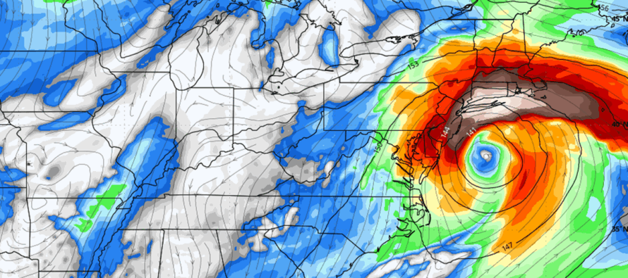
Discussion: Not much has changed from yesterday’s update to today. The same upper level synoptics are still in place which is a phase and capture involving an upper low and coastal low. So, I will again break down the expectations by condition type:
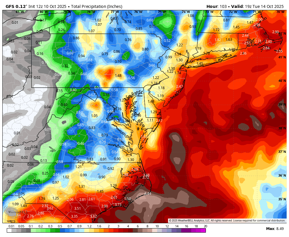
Rain could start as early as noon on Saturday (tomorrow), possibly earlier in the morning. But it will likely be more of a misty light rain situation rather than the steadier rain expected later in the storm. The steadier stuff should move in from the S later Saturday night into Sunday morning and push further N into the rest of NJ by noon on Sunday. It’s then game on for rain throughout the rest of Sunday, all of Monday and into at least Tuesday morning with some expected few-hour lulls between the longer periods of rain. I’d allow rain to last into Tuesday evening just to play it safe. Again, NWNJ is expected to see less rain than SENJ. NWNJ will be last for the rain to fill in and first to end. SENJ should be ground zero for the most rainfall when all is said and done. As described yesterday, a good base expectation is between .5 and 1.5 inches for NWNJ, between 1.5 and 2.5 inches for the I-95/NJTP corridor area (SWNJ through CNJ into NENJ) and between 2 and 3 inches for SENJ/coastal regions. It is possible that some coastal SENJ areas exceed 3 inches of total rainfall when all is said and done Tuesday night but that’s on a wildcard basis. Here’s the latest guidance from the GFS for rain through Tuesday night:
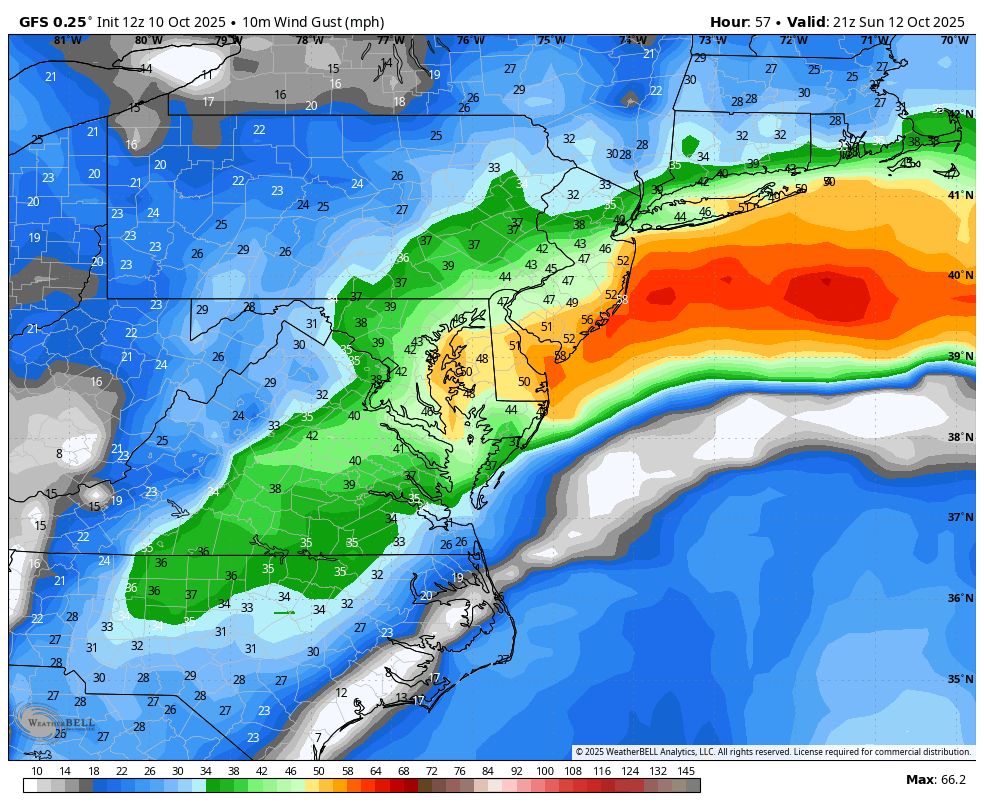
Winds are expected to be highest along the ECNJ/SENJ coasts directly off the ocean. Everyone away from the ocean and up in NNJ should see less winds than the coastal areas. Once wind conditions peak, I think we can all (NJ) bank on sustained winds of 15-25mph with gusts to 45mph away from the coast. NNJ elevations might verify slightly higher than that given their closer elevation to the lower jet which will be raging above 70mph. Also during peak winds, I think the coast can bank on sustained winds of 25-35mph with gusts to 60mph+. How much of that raging lower jet can be brought to the surface will depend on rainfall down drafting and subsidence reacting to neighboring forcing. For timing of winds, they should gradually build out of the E starting tomorrow (Saturday), ramp up to about 50-75% of peak for Sunday morning and then peak later Sunday night into Monday morning/afternoon. Winds should then subside Monday night into Tuesday morning. Here’s the peak latest peak wind field from the GFS showing Sunday PM:
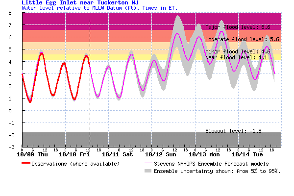
Coastal flooding remains the primary concern for this system and obviously only for coastal regions. I’m seeing 3 high tides of concern where major flooding is most probable. That would be Sunday around noon, early Monday AM and then Monday afternoon. During these times, the flooding guidance (see below) predicts water levels 7-8 feet above Mean Lower Level Water (MLLW) which is basically the recent average of low tide levels. Since a normal high tide is about 3-4 feet above a normal low tide, it is safe to expect the ocean and bays to rise 3-5 feet above normal high tide. This should flood most streets along the coast and possibly enter some first floors of lower housing structure. Park your vehicles as high as possible.
In English: A nor’easter will begin moving in on Saturday. It should ramp up Sunday, peak Sunday night into Monday morning and then subside Monday afternoon/evening through Tuesday morning. Expect rain and wind with the worst of it along the ECNJ/SENJ coast (including coastal flooding). Areas away from the ocean and up in NNJ should see less intense rain and wind but still a possible doozy. We’ve seen these many times before. It’s just that we haven’t seen it in a while. Therefore, it could feel kind of raw and the duration of it could feel somewhat exhausting. Most coastal lows that have happened over the past few years have been regular coastal lows…6-12 hour storms. This should be a 36-48+ hour event. The rainfall is much needed. The wind-related power outages, coastal flooding and outdoor plan ruining will be annoying/frustrating. There’s not much more to say. Live observations will begin tomorrow when first drops move in from the S/off the ocean. I’m going to stock up on comfort food ingredients, put fresh batteries in the flashlights, secure loose outdoor decorations/small human beings, and make some killer pot roast/soup/etc. I suggest you do the same. Have a great weekend otherwise and please be safe! JC
Premium Services
KABOOM Club offers ad-free content, inside info forecast discussion, your questions answered, and early storm impact maps and video releases (ahead of the public). At $1.99 per month, it’s an extremely feasible way to show additional support for Weather NJ and you can turn it on and off for however many months you wish. Think of it as a tip jar with perks. Available onFacebook or Patreon.
My Pocket Meteorologist (MPM), in partnership with EPAWA Weather Consulting, offers professional/commercial interests, whose businesses depend on outdoor weather conditions (snow plowing, landscaping, construction, etc.), with hyper-local text message alerts/forecasts from real meteorologists and access to the MPM premium forum—the most comprehensive and technical forecast discussion available for PA and NJ.
Jonathan Carr (JC) is the founder and sole operator of Weather NJ, New Jersey’s largest independent weather reporting agency. Since 2010, Jonathan has provided weather safety discussion and forecasting services for New Jersey and surrounding areas through the web and social media. Originally branded as Severe NJ Weather (before 2014), Weather NJ is proud to bring you accurate and responsible forecast discussion ahead of high-stakes weather scenarios that impact this great garden state of ours. All Weather. All New Jersey.™ Be safe! JC


LOCAL FORECAST | INTERACTIVE RADAR | LATEST NJ WEATHER ALERTS | WEDDING FORECAST| PRIVACY POLICY
© Copyright 2026 Weather NJ LLC. All Rights Reserved.
Some information that can be found on our website is provided by a private weather station and is not an officially recognized station for weather reporting. Though we always strive to achieve accurate reporting for our own use, it is important that you do NOT depend on the data provided here for any purpose.
