

Nor’easter Update
Discussion: I see a lot of people away from the ocean and up in NNJ wondering where the storm is. I see a lot of people in the coastal regions already crying uncle. I figure a thorough update, in article format, is due so that everyone can get on the same page.
Earlier this week I jumped on the “Nor’easter is a go” train. I did this because I saw great agreement in data as well as live observations of a pattern that supports such an event. I went out of my way to emphasize that areas NW of I-95 will see a run-of-mill rain and wind event while the ECNJ/SENJ coast will see the worst of in in the form of rainfall, wind gusts and coastal flooding. Something happened on Wed-Thurs though. The models had a period where the data suggested a perfect phase of the upper low with the coastal low. This brought the crazier expectation (inches of rain and big winds) NW of I-95 even into PA and NY. I saw a bunch of outlets run with this and make it their forecast. Time and experience has taught me to never trust a capture/phase. We’ve been through the great blizzard bust of Jan 2015 together. We’ve been through the Sept 2016 missed phase of Hurricane Hermine together. A perfect phase is a unicorn and it should be treated as a wildcard possibility, not a certain expectation. That’s why I never went with inches of rain for NWNJ or gusts to 60+ for NWNJ. Bobby Martrich of EPAWA and I have been in strong agreement on this all week. This is a coastal battering, not an inland battering. You can go back and read my articles and see for yourself. You can go back and ingest Bobby’s content as well. We try our best to bring the most realistic forecast as possible to you without unnecessary hype. Nowadays, social media weather outlets are a dime a dozen and many are in it just for click revenue. Neither Bobby nor I are like that. Our mission is to prepare you for safety awareness first and foremost. Weather doesn’t need additional hype. A strong enough event carries and commands its own natural presence of excitement…and we’ll have as much fun with that as possible (ex: Godzilla, Kaboom, Dude Where’s my Carr?, etc.) but we won’t let you down in realistic expectations and preparing with safety in mind. Don’t forget your OGs who played a major part in pioneering social media forecasting back in 2009-2010. There’s a reason Bobby and I each have over a quarter million REAL people who still follow us after 15 years. Anyway, on Friday, the models lost the perfect phase idea and the idea of a dangerous system NW of I-95 vanished. Expectations, from data, returned to what it was earlier this week. So, with that rant out of the way, let’s discuss what is happening now instead of the perfect phase that could have been.
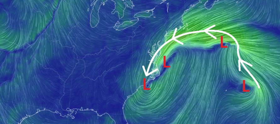
There’s a lot going on in the coastal US Atlantic right now. We have the remnants of Hurricane Jerry and Karen still spinning below tropical storm criteria far out near Bermuda. We have a primary coastal surface low that sat of Wilmington, NC all day today and we now have a secondary surface coastal low forming off Delmarva which the primary is following—trying to merge into. They seem to want to do their own little Fujiwhara dance before speeding out on Tuesday. But in general, you have this large onshore fetch from just N of Bermuda moving towards New England and then diving downwards over the two surface coastal lows. It will eventually form a single surface low before pulling away. But right now, it’s still multiple lows that haven’t phased yet. This is powering a strong 850mb lower-level jet streak that is only now just bringing the heavier winds and rainfall into the Jersey Shore. Again, had this had been the perfect phase, that jet would extend far inland. But the phase did not happen therefore it’s not, it’s only ramming into the Jersey Shore SE of the I-95 corridor.
Earlier this week I spoke about how we really haven’t seen a prolonged nor’easter with a stall and retrograde since March 2018. Many seem to expect all conditions verifying today (total rainfall, peak winds, all coastal flooding, etc.). I see this with snow systems too. People wake up first thing in the morning and scream bust for a snow event expected to start later that day. This is a prolonged nor’easter for the Jersey Shore and most areas SE of I-95. If this storm was a baseball game, we’re about through the 4th inning. We’re only now (Sunday night) getting into peak conditions, and this will last well into Monday morning/afternoon. There are still two high tides of concern for the Jersey Shore, about 1AM overnight tonight and then a third around 1PM tomorrow (Monday). Only after that will the coast be off the hook for coastal flooding. Winds are performing as expected along the coast with gusts in the 50-60mph range. There’s a lot of time for the rain to still push into NNJ/NWNJ/SWNJ. The precipitation shield is expanding as we speak. Again, though…NWNJ was never ground zero for a dangerous storm system. They were always forecasted for the least amount of rain and wind in NJ.
So, buckle up along the coast, it’s going to be a long ride through Tuesday morning. We still have all of Monday to get through. For areas away from the ocean and up in NNJ, I get why you are asking “what storm?” after some of the stuff I’ve seen from other outlets jumping on the phase train. You’re going to still see some rain and wind but it will seem run-of-mill compared to what the coast is experiencing.
Expect rain and wind to push further into all of NJ including NWNJ and west sides of NJ that didn’t see much at all today. It’s not going to clobber you though. It’s going to seem nuisance. It might just fall short of the rain and wind expectations due to the chaotic 4-system Atlantic situation right now pulling on each other. But it was never your storm. For ECNJ/SENJ, this is your storm and you should expect what was predicted (what has already verified for many) …a few inches of rain, wind gusts to 60mph, and moderate to major stage flooding. We’re just short of halfway through it all.
In English: We’re almost halfway through this system and you should let it finish up Tuesday morning before judging the forecast. A run-of-mill rain and wind situation for much of NJ but a solid nor’easter for the ECNJ/SENJ coasts. Thank you all for the imagery and video content of the ECNJ/SENJ coastal flooding that has occurred so far. We have a while to go still. Have a great rest of your night and please be safe! JC
Premium Services
KABOOM Club offers ad-free content, inside info forecast discussion, your questions answered, and early storm impact maps and video releases (ahead of the public). At $1.99 per month, it’s an extremely feasible way to show additional support for Weather NJ and you can turn it on and off for however many months you wish. Think of it as a tip jar with perks. Available onFacebook or Patreon.
My Pocket Meteorologist (MPM), in partnership with EPAWA Weather Consulting, offers professional/commercial interests, whose businesses depend on outdoor weather conditions (snow plowing, landscaping, construction, etc.), with hyper-local text message alerts/forecasts from real meteorologists and access to the MPM premium forum—the most comprehensive and technical forecast discussion available for PA and NJ.
Jonathan Carr (JC) is the founder and sole operator of Weather NJ, New Jersey’s largest independent weather reporting agency. Since 2010, Jonathan has provided weather safety discussion and forecasting services for New Jersey and surrounding areas through the web and social media. Originally branded as Severe NJ Weather (before 2014), Weather NJ is proud to bring you accurate and responsible forecast discussion ahead of high-stakes weather scenarios that impact this great garden state of ours. All Weather. All New Jersey.™ Be safe! JC


LOCAL FORECAST | INTERACTIVE RADAR | LATEST NJ WEATHER ALERTS | WEDDING FORECAST| PRIVACY POLICY
© Copyright 2025 Weather NJ LLC. All Rights Reserved.
Some information that can be found on our website is provided by a private weather station and is not an officially recognized station for weather reporting. Though we always strive to achieve accurate reporting for our own use, it is important that you do NOT depend on the data provided here for any purpose.
