

Nov 13: The New Model Gets It’s First Test!
Being that we may see some snow tonight and also being that we have temperatures at a place where we are simply unsure of what if anything is going to happen, I thought we could take a look at what one of the newest models of the atmosphere is saying and what it means for New Jersey.
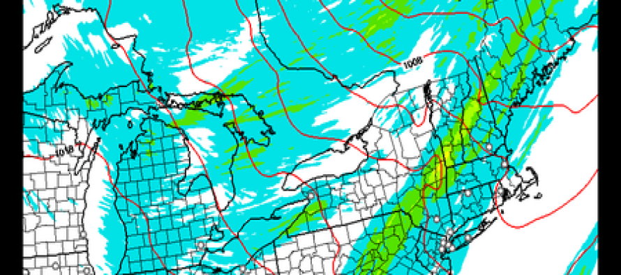
The HRRR model or the Rapid Refresh model comes out every hour! My how times have changed. Back in the day you got models twice a day or even just once a day. Now we get it every hour. But I digress! This is for tonight at 11pm. The first map is total snowfall for the last 15 hours followed by total precipitation in the last 15 hours.
Notice a couple of things right off the bat. First off is the amount of snow being shown around the great lakes due to lake effect comes up pretty well. Also at least as of 11pm the accumulating snow is probably no further east then Eastern Pennsylvania. And much of the precipitation that is falling over New Jersey up until that point is spotty and light. So at least we can conclude from this that for the first part of tonight not much of consequence is going to happen other than some spotty light rain which will probably be mixed with wet snow inland.
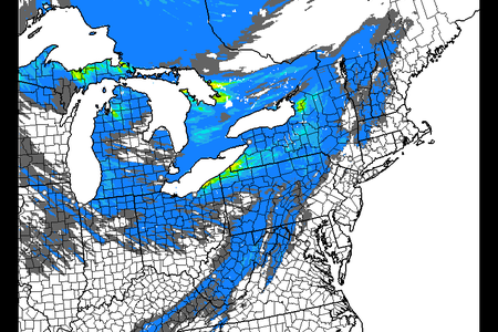
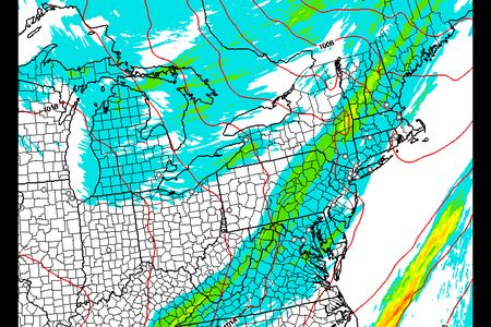
Now to the second half of the night. At this point we need to jump to one of the other short range models and for that we will probably go to the gfs model here which takes us through the second half of the night. The first map is for 1am and the second for 7am. Notice the precipitation breaks out during that time frame over New Jersey and points east. It generates about a quarter of an inch or so which is not too shabby considering the overall situation we are dealing with. By Friday morning precipitation is likely winding down and ending from west to east.


The big variable here is something that we don’t really know until it is actually happening. How cold is the atmosphere going to be? And what happens in reality when precipitation is coming down? In situations like this a process known as dynamic cooling is taking place. In English what it means is that the developing and falling precipitation causes the atmosphere to cool. The result often times is that what you think falls as rain winds up falling as snow. The intensity of the precipitation is key here. If it comes down hard enough, the bottom part of the atmosphere where of course we reside, will cool more than models show. We know this through so many past experiences of being burned. This is how you wind up with a surprise snowfall.
I don’t want to overdo this. In the end we are talking about nothing more than a cheap thrill for snow lovers. And lord knows that first coating to an inch can make the morning commute a nightmare. The bottom line is that we probably are not going to know just exactly what is going to happen until it is actually happening.
So tonight will be a nice test for all. New model and perhaps our first accumulating snow. And do please visit my website www.meteorologistjoecioffi.com for my on views on the weather and of course do like and share me on facebook on my weather page facebook.com/meteorologistjoecioffi and on twitter @joecioffi
Jonathan Carr (JC) is the founder and sole operator of Weather NJ, New Jersey’s largest independent weather reporting agency. Since 2010, Jonathan has provided weather safety discussion and forecasting services for New Jersey and surrounding areas through the web and social media. Originally branded as Severe NJ Weather (before 2014), Weather NJ is proud to bring you accurate and responsible forecast discussion ahead of high-stakes weather scenarios that impact this great garden state of ours. All Weather. All New Jersey.™ Be safe! JC


LOCAL FORECAST | INTERACTIVE RADAR | LATEST NJ WEATHER ALERTS | WEDDING FORECAST| PRIVACY POLICY
© Copyright 2026 Weather NJ LLC. All Rights Reserved.
Some information that can be found on our website is provided by a private weather station and is not an officially recognized station for weather reporting. Though we always strive to achieve accurate reporting for our own use, it is important that you do NOT depend on the data provided here for any purpose.
