

Nov 15: Coastal Storm Developing
Discussion: Our coastal storm is currently developing off the coast of Georgia and South Carolina. It should remain offshore and track to about OBX latitude before stalling. High pressure over the NE US will hold it there for a little and then it will continue it’s track to the NE with the low center well offshore. We have a trough forming in the NW US that will race across the US towards the Mid-Atlantic. I’m starting to consider the possibility of more interaction between the trough and ocean low once the players are over the E US/W Atlantic. If the NE US high holds the storm in a stall position off OBX for longer than currently modeled then the low and/or trough could pull each other towards each other. This would mean more significant impacts for New Jersey including precipitation possibly ending wintry for interior and elevations. This is something I’ll be watching closely tonight and tomorrow. But for now here are the reasonably expected impacts by category:
Rain: Rainfall should begin between Sunday morning and afternoon and taper off by Monday evening if not earlier. We could then see another round Monday night into Tuesday morning but that is more uncertain than the Sunday-Monday rain. I think most areas will struggle to see an inch of rain total from the entire event. And SNJ/SENJ is more favored to see rain than NNJ/NWNJ. We’re likely talking about the misty/drenching onshore wind-blown rain not the heavy drop stuff you see in a thunderstorm downpour. I doubt rainfall intensity would reach flash flooding criteria even in localized instances. Therefore, rainfall is the least of my concerns regarding storm impacts.
Wind: I say this with every coastal storm event. Areas more than 5-10 miles away from the ocean will likely ask, “what wind/what storm?” Areas along the immediate coast (from Sandy Hook to Cape May) should be rocking. it’s simple…land friction. There’s nothing preventing coastal wind gusts of 30-40mph possibly higher IMO during peak storm intensity. Winds should gradually pick up out of the N/NE starting Saturday morning and increase by Saturday night. Winds should then peak on Sunday out of the E/NE and switch back to the N/NE by Sunday night into Monday morning. Winds could then remain gusty through Monday afternoon/evening as wind direction switches around to the W/NW (low moves to our NE over coastal New England). I then expect winds to subside by Tuesday morning.
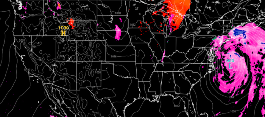
Coastal Flooding: There are 6 high tides I am watching for coastal flooding along the ENJ coast and SWNJ Delaware Bay coast. The first two occur Saturday (AM and PM) and should only reach the minor category of coastal flooding. The next 4 high tides have moderate coastal flooding potential (Sunday AM and PM and Monday AM and PM). The above model image shows the expected storm location at 2am Monday morning. I’ll throw a super small chance of low-end major category for areas between Cape May and Atlantic City. Tuesday morning’s high tide should then be back to just a minor category risk as everything pulls away. Normal water levels should ensue by Tuesday evening.
Wintry Concerns: I in no way wish to advertise this synoptic system as a snow storm. The surface temperature profile is too warm for most of New Jersey regardless of how much cold moves in aloft. If anyone is going to see wintry precipitation it would be Monday night into Tuesday ONLY if there is wrap-around precipitation behind the departing low (interacting with the approaching trough). NWNJ would be best favored for it. As I said in the first paragraph for now it doesn’t look wintry but I’ll be monitoring any trends should the trough and ocean storm interact more.
In English: Today felt pretty mild after the prior few days of Arctic cold. Tomorrow should be mostly dry but clouds move in and winds pick up off the ocean. Rain and higher winds are then likely between Sunday and Monday morning…also when the highest coastal flooding risk exists. Most of this should wrap up by Monday afternoon but there’s a small chance of another batch of rain Monday night into Tuesday morning (back side of storm). This batch has a small chance of ending wintry with NWNJ favored for such. As of right now however the most reasonable evidence-based prediction is a cold rain for most. Everyone have a safe, warm and dry weekend. I’ll be tracking. Please be safe! JC
Download the new free Weather NJ mobile app on Apple and/or Android. It’s the easiest way to never miss Weather NJ content. Our premium services go even further above and beyond at the hyper-local level. Looking for industrial-caliber long-range forecasting data that I personally recommend? Check out WeatherTrends360!
Jonathan Carr (JC) is the founder and sole operator of Weather NJ, New Jersey’s largest independent weather reporting agency. Since 2010, Jonathan has provided weather safety discussion and forecasting services for New Jersey and surrounding areas through the web and social media. Originally branded as Severe NJ Weather (before 2014), Weather NJ is proud to bring you accurate and responsible forecast discussion ahead of high-stakes weather scenarios that impact this great garden state of ours. All Weather. All New Jersey.™ Be safe! JC


LOCAL FORECAST | INTERACTIVE RADAR | LATEST NJ WEATHER ALERTS | WEDDING FORECAST| PRIVACY POLICY
© Copyright 2026 Weather NJ LLC. All Rights Reserved.
Some information that can be found on our website is provided by a private weather station and is not an officially recognized station for weather reporting. Though we always strive to achieve accurate reporting for our own use, it is important that you do NOT depend on the data provided here for any purpose.
