

Nov 17: Transitional Period Before the Reload Begins!
From the standpoint of how the atmosphere works bear in mind that it really is a series of stress relief! What I mean by that is the atmosphere like many things in life get stressed. That stress needs to be relieved. And once relieved like many of us we like to relax a bit. This is kind of what is happening here over the next week to 10 days. We will go from an extreme position in the upper flow..to something more relaxed for Thanksgiving week before the next change gets underway. By something more relaxed IT does not necessarily mean storm free.
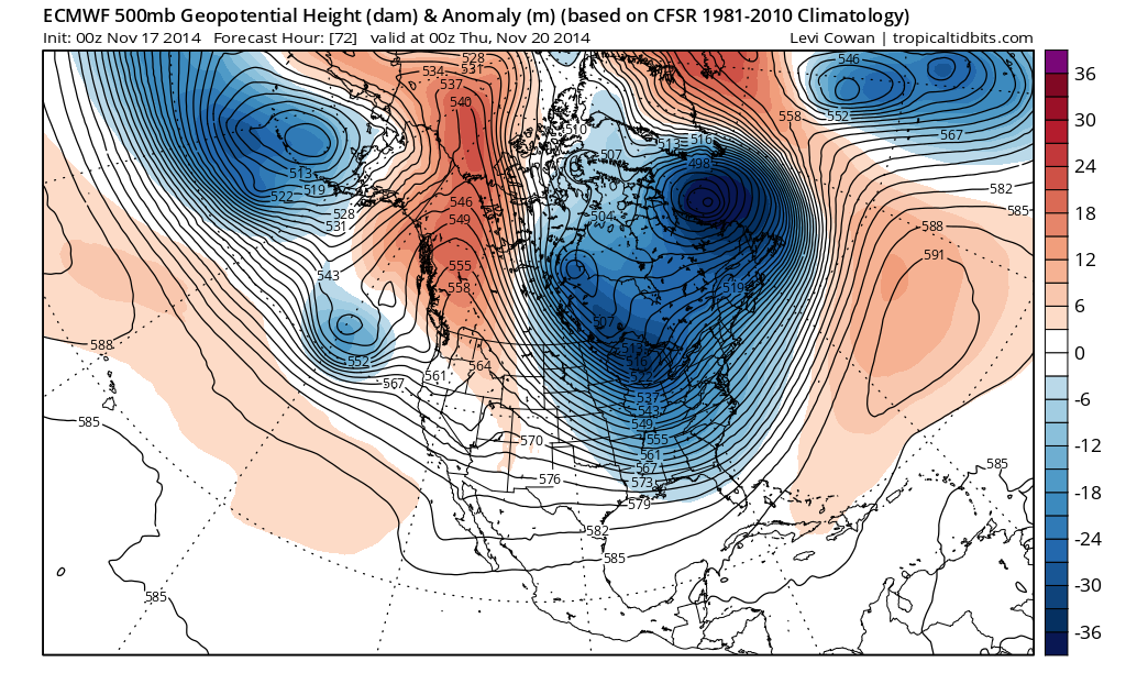
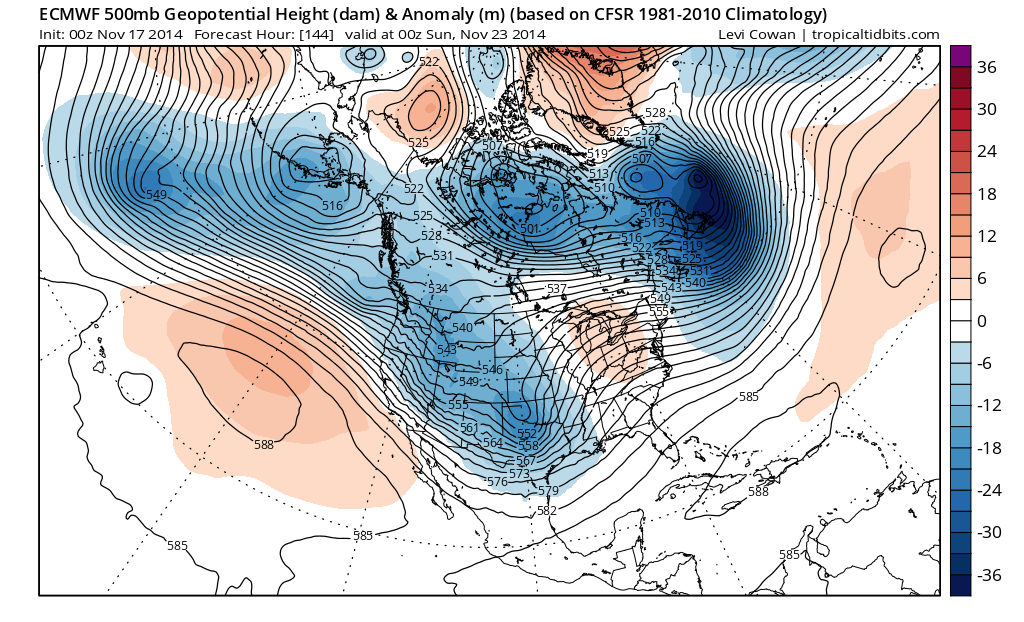
Wednesday’s European model view shown above (first map) here is when the atmospheric flow is at it’s most stressed position. Notice that we have a strong flow coming straight down from northwest Canada into the Northeast and Mid Atlantic states. The core of the cold air will be with us on Wednesday. Beyond Wednesday we begin a slow moderation. The second map is for next Sunday. Notice that now in the 500mb map which is in the upper left corner, the flow no longer comes from Canada but runs pretty much straight across with a dip in the middle. Way up near the top you can see that the air in Canada is basically moving west to east. This means that cold air is pretty much cut off and we have mostly Pacific air. The dip in the middle is reflecting a storm that is going to head to the Western Great Lakes with probably some rain for us at some point.
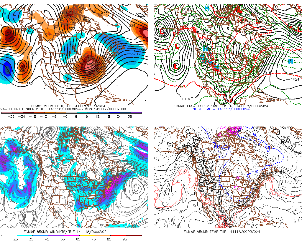
Now beyond Wednesday comes the next change. The map above is for Wednesday night. Notice how it changes from Sunday. The flow from Canada becomes reestablished and brings down colder air into the United States. However notice that the flow is not very strong yet. It is a little weaker than the very first map we looked at which is bringing down the cold air for this week. Still the important thing to focus on is that the change seems to want to go back to the original positions.There is a trough in the east. Ridge in the west. There is a deep low in the Gulf of Alaska/Aleutians. There is ridge in the Atlantic but it is out offshore. All of these things seem to indicate that we are going to see a temporary lull in the overall pattern before going back to a cold Canadian flow. The question of storminess and snow is a different issue.
Not all models go along with this idea. Take a look at the parallel GFS model which is the American Model. For the same time frame as the European it shows a completely different view. No flow from Canada and still a west to east flow across the United States. This suggests that the warmer than normal conditions will carry us through to Thanksgiving day and shows no real sign of a reload to the cold pattern we are in right now..at least through the middle of next week.
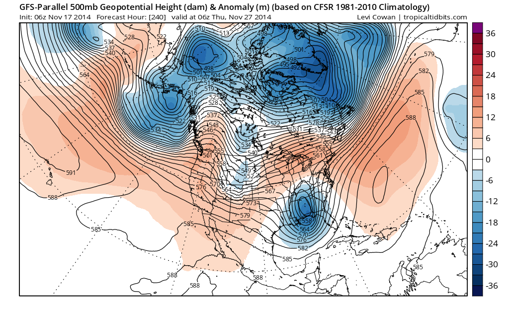
What can we conclude from this? Well for one thing, anyone who claims they have it all figured out is handing you a line. Secondly if we look carefully at the American model above, it seems all the large scale features are in a position where they would revert back to a cold wintry pattern in the east. It just may take a little longer to get there. Long range is tough to figure. And while history never repeats itself it does tend to rhyme at least for a few weeks. So we will patiently wait and see where this all takes us. In the meantime stay warm with record cold for the next few days.
In English: Once the cold pattern relaxes after this week, expect a period of mild/above average temperatures to take us into Thanksgiving. After that, the colder pattern should reload for December.
Joe Cioffi has been a meteorologist in the New Jersey/New York area for the last 30 years on NJ 101.5 radio and WPIX TV in New York. You can follow him on facebook (facebook.com/meteorologistjoecioffi) and Twitter (@joecioffi) or visit his website at www.meteorologistjoecioffi.com.
Jonathan Carr (JC) is the founder and sole operator of Weather NJ, New Jersey’s largest independent weather reporting agency. Since 2010, Jonathan has provided weather safety discussion and forecasting services for New Jersey and surrounding areas through the web and social media. Originally branded as Severe NJ Weather (before 2014), Weather NJ is proud to bring you accurate and responsible forecast discussion ahead of high-stakes weather scenarios that impact this great garden state of ours. All Weather. All New Jersey.™ Be safe! JC


LOCAL FORECAST | INTERACTIVE RADAR | LATEST NJ WEATHER ALERTS | WEDDING FORECAST| PRIVACY POLICY
© Copyright 2026 Weather NJ LLC. All Rights Reserved.
Some information that can be found on our website is provided by a private weather station and is not an officially recognized station for weather reporting. Though we always strive to achieve accurate reporting for our own use, it is important that you do NOT depend on the data provided here for any purpose.
