

Nov 20: Watching Saturday Night
Discussion: Not much to write home about over the next few days. A warm front should move through from SW to NE Thursday PM. Therefore we’ll have milder and more humid air moving into a colder departing air mass with lower dew points. This sounds like a synoptic recipe for fog in my opinion. With that said please be careful Thursday night and Friday morning should dense fog come into fruition.
Friday then looks very mild for this time of year. Many spots should flirt with reaching/breaking 60. A cold front is then expected to pass through from the W/NW between Friday afternoon and evening. This will chill the region down pretty good for Friday overnight into the first half or so of Saturday.
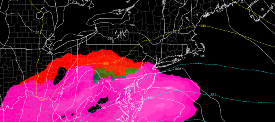
On Saturday afternoon a synoptic disturbance/wave should track across the Mid-Atlantic US from W to E. This sets up a period of precipitation between Saturday afternoon and early Sunday morning. For most of New Jersey this should be a cold rain however I am becoming concerned about NJ areas N of I-80 especially the elevations.
700mb (~10,000 ft) and above will be below freezing during the period of precipitation. So we have cold air aloft. 850mb (~5000ft) and below are currently modeled slightly above freezing which would typically indicate a cold rain for all of New Jersey. There’s a catch however. If precipitation is intense enough and/or the surface low deepens/intensifies below 995mb then we could see the colder air aloft brought down to the lower-levels and/or an adiabatic cooling process (temperatures drop with pressure drop/expansion of air). For these reasons I would throw a small chance of wintry precipitation on the table for all areas N of I-80 in New Jersey especially NWNJ elevations. This will be an 11th hour call if either of these two wildcards happen. For now a cold rain for all areas is the most reasonable expectation given the warmer lower-levels.
We’ll then dry out and improve on Sunday with tranquil conditions expected through at least mid-next week thanks to a broad area of high pressure dominating the E US.
In English: Temps should warm up tomorrow night into Friday morning (watch out for fog) then chill down Friday night into Saturday morning. A cold rain is expected between Saturday afternoon and early Sunday morning. Areas N of I-80 especially NWNJ elevations could see wintry precipitation with any little trend colder so for that reason I am watching it closely. I’ll provide a full update tomorrow evening for the weekend outlook. That will give me a full 24 hours from now of fresh data to analyze. Everyone have a great night and please be safe! JC
Download the new free Weather NJ mobile app on Apple and/or Android. It’s the easiest way to never miss Weather NJ content. Our premium services go even further above and beyond at the hyper-local level. Looking for industrial-caliber long-range forecasting data that I personally recommend? Check out WeatherTrends360!
Jonathan Carr (JC) is the founder and sole operator of Weather NJ, New Jersey’s largest independent weather reporting agency. Since 2010, Jonathan has provided weather safety discussion and forecasting services for New Jersey and surrounding areas through the web and social media. Originally branded as Severe NJ Weather (before 2014), Weather NJ is proud to bring you accurate and responsible forecast discussion ahead of high-stakes weather scenarios that impact this great garden state of ours. All Weather. All New Jersey.™ Be safe! JC


LOCAL FORECAST | INTERACTIVE RADAR | LATEST NJ WEATHER ALERTS | WEDDING FORECAST| PRIVACY POLICY
© Copyright 2026 Weather NJ LLC. All Rights Reserved.
Some information that can be found on our website is provided by a private weather station and is not an officially recognized station for weather reporting. Though we always strive to achieve accurate reporting for our own use, it is important that you do NOT depend on the data provided here for any purpose.
