

Nov 21: Big Big Changes Coming!
FROM THE 30S TO 70..BACK TO 30S OR LOWER – SNOW THREAT LOOMS FOR THANKSGIVING!!!
Anytime you see indications of big temperature swings coming it is often pointing to huge things happening in the upper atmosphere. And often times right after the swing takes place, there is the potential for something important to occur.
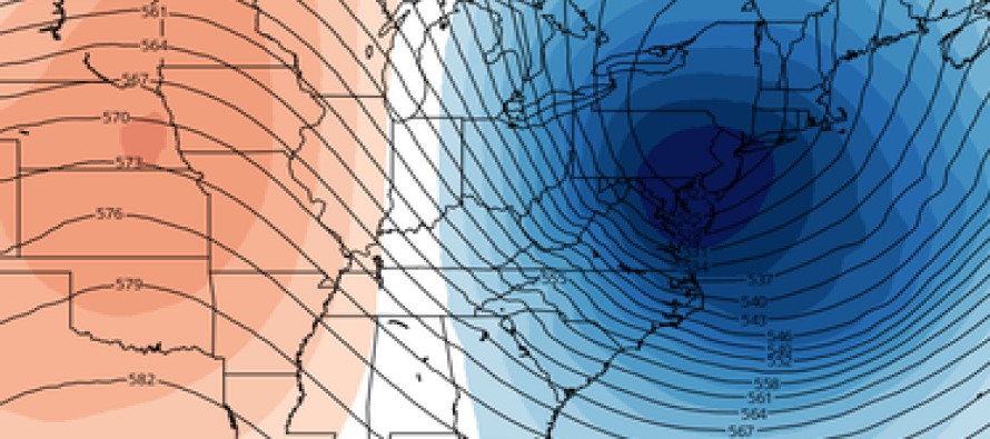
First off I want to back track to 2 days ago. Tuesday night I was looking through the latest run of the models when I saw this being indicated by the parallel GFS model and it really caught my attention. It isn’t very often you see the upper flow look like this. Now literally looking at this you come to a pretty east conclusion. A flow like this means very cold but very dry. However when looking beyond 5 days into the future it is important for forecasters not to look a the literal translation of what any particular model is telling. It is really important to figure out what is going on in a deeper way.
What struck me about this was the incredible dynamics being shown. This is an exceptionally cold push of air aloft coming right overhead. Seeing this and using a little imagination, it became clearer to me that the atmosphere was going to have its version of some sort of headache and it would need to be relieved by some sort of storm development somewhere along or off the east coast. It didn’t matter that it didn’t show anything literally because at that point into the future, forecasters know that it would be gone or at least different on the runs that follow. And indeed that was the case. The next several runs settled back away from this idea. So I waited for more clues as we got closer. I just couldn’t get the notion out of my head that with all that is going on in this very strong upstream flow, that something could happen as this evolves over time.
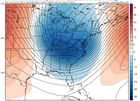
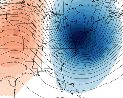
Now let us fast forward to today. This is what the upper flow is looking like and make no mistake this is very impressive. We have gone from nothing to something. Notice first off how much further left everything is. And also notice that while not sharp..there is energy (shown in the dark blue) digging and swinging around. The position of this upper trough is far enough left that one must now consider that storm development will occur and that it will be along or just off shore. And as this feature swings around and deepens, it will cause the coastal low to deepen as well.
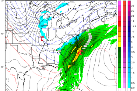
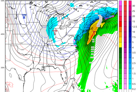
Now this is how this plays out at the surface. A low forms just offshore and intensifies as it moves northeast. Plenty of cold air seems to be around to get entrained into the coast and the result is that the precipitation is snow. It is particularly interesting to me that this model shows snow as I have noticed through limited use that it has a bit of a warm bias. But that could just be me and not hands on use. While this would probably not be a big event because of speed issues (low moving fairly fast) it certainly could mean the first accumulating snow for the coast and it would be timed for Wednesday night into Thanksgiving day!
Now remember we are very early in this game. And I suspect the models may change even more between now and over the weekend. What could change? Well we could see where the northern part of the jet stream goes back to being dominant and overwhelming like the first map I posted which means all this happens but winds up going way out and nothing happens here. Today’s Canadian model is giving that idea. And there is also another possibility and that is that this could evolve into something even more important in terms of snowfall if that upper flow is sharper and even deeper than being indicated. Forecasters will need to pay extra close attention to model trends before coming to any conclusions and it will be even more important to not modelcast or model hug. Take a step back and see what is actually happening.
Meanwhile as we head into the weekend we will go from Friday where it never got out of the 30s in many locations to Sunday and Monday where temperatures will take off to 60s to near 70 with some rain Sunday night. Long range beyond next week it appears that the pattern will remain very dynamic so do not be surprised if we get more early winter surprises with respect to both cold and potential snow events.
In English: Between how cold it is now, how warm it will be on Monday, and the potential snowfall around Thanksgiving, big changes are happening. The wild swings in temperatures this time of year can lead to bigger snow events so let’s see how this plays out on Thanksgiving and the start of December.
Joe Cioffi has been a meteorologist in the New Jersey/New York area for the last 30 years on NJ 101.5 radio and WPIX TV in New York. You can follow him on facebook (facebook.com/meteorologistjoecioffi) and Twitter (@joecioffi) or visit his website at www.meteorologistjoecioffi.com.
Jonathan Carr (JC) is the founder and sole operator of Weather NJ, New Jersey’s largest independent weather reporting agency. Since 2010, Jonathan has provided weather safety discussion and forecasting services for New Jersey and surrounding areas through the web and social media. Originally branded as Severe NJ Weather (before 2014), Weather NJ is proud to bring you accurate and responsible forecast discussion ahead of high-stakes weather scenarios that impact this great garden state of ours. All Weather. All New Jersey.™ Be safe! JC


LOCAL FORECAST | INTERACTIVE RADAR | LATEST NJ WEATHER ALERTS | WEDDING FORECAST| PRIVACY POLICY
© Copyright 2026 Weather NJ LLC. All Rights Reserved.
Some information that can be found on our website is provided by a private weather station and is not an officially recognized station for weather reporting. Though we always strive to achieve accurate reporting for our own use, it is important that you do NOT depend on the data provided here for any purpose.
