

Nov 24: Winter Storm Update
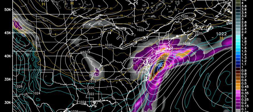
A winter storm is still expected for this Wednesday which will impact millions of people traveling for the Thanksgiving Holiday. Most model guidance is currently suggesting a coastal low pressure track near or just inside the benchmark (40N/70W). There is also going to be a warm layer in the atmosphere from current surface conditions. This is a lot to overcome for the coastal plain to see snow accumulations but when all is said and done, I think there are enough ingredients to make it happen. With that being said, here are my “updated thoughts” on this Wednesday regarding snowfall accumulations:
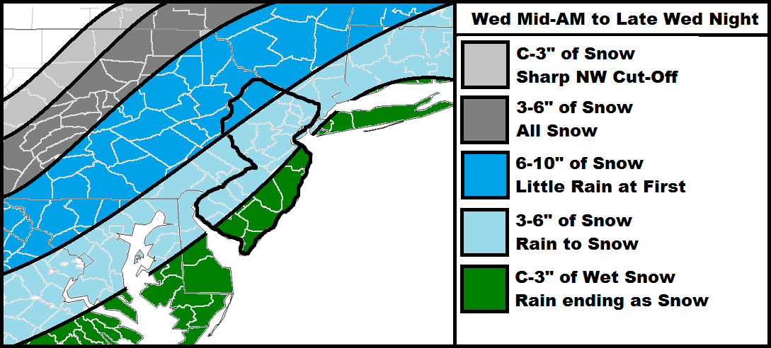
The lighter gray area represents the furthest NW accumulations. Expect powdery snow with a sharp NW cutoff meaning it can go from a few inches to nothing in just 10-15 miles.
The darker gray area should be all snow from start to finish with significant accumulations possible.
The darker blue area should see the jackpot accumulations of the entire system. While some areas in this region could start as rain, they should quickly go over to snow. Are localized areas of 12 inches+ possible? I suppose but 6-10 is a safer bet at this point—in my opinion.
The lighter blue area represents the hardest call to make with this system. That warm layer of the atmosphere I mentioned before will be at play along with onshore warmer winds off the ocean. This should keep surface temperatures warmer for longer but eventually winds will switch to the N and crash temperatures below freezing. It’s the case where a foot of snow could fall but only 3-6 inches of it sticks. Regardless, expect this to start as rain, change to snow and eventually accumulate.
The green area should see rain for the majority of the storm system but end as snow. Immediate coastal areas could see minor tidal flooding and beach erosion with little to no accumulation. Areas closer to the lighter blue have a better chance to end with a few slushy inches than barrier islands.
Timing seems a little faster with most of the system happening between mid-Wednesday morning and midnight Wednesday night. This still makes Wednesday a rough day to travel, especially along the I-95 corridor and any highways northwestward of there. By Thursday morning the system will be cleared out and road conditions will be subject to plowing efficiency. I imagine highways will be fine with secondary and side roads a mess. For coastal/SENJ, it shouldn’t be much of an issue at all.
In English: It’s becoming likely that Wednesday will start with rain as early as mid-morning and end as snow. Higher NWNJ elevations have the best chance for accumulations (might stay all snow) and extreme SENJ has the worst (might stay all rain). Everyone in the middle will see a battle between rain vs. snow that will have to be live-casted on Wednesday. Be safe! JC
Jonathan Carr (JC) is the founder and sole operator of Weather NJ, New Jersey’s largest independent weather reporting agency. Since 2010, Jonathan has provided weather safety discussion and forecasting services for New Jersey and surrounding areas through the web and social media. Originally branded as Severe NJ Weather (before 2014), Weather NJ is proud to bring you accurate and responsible forecast discussion ahead of high-stakes weather scenarios that impact this great garden state of ours. All Weather. All New Jersey.™ Be safe! JC


LOCAL FORECAST | INTERACTIVE RADAR | LATEST NJ WEATHER ALERTS | WEDDING FORECAST| PRIVACY POLICY
© Copyright 2026 Weather NJ LLC. All Rights Reserved.
Some information that can be found on our website is provided by a private weather station and is not an officially recognized station for weather reporting. Though we always strive to achieve accurate reporting for our own use, it is important that you do NOT depend on the data provided here for any purpose.
