

Nov 25: Final Snow Map for Wednesday Winter Storm
Here’s my final snow map for tomorrow. A coastal winter storm will impact most of the mid-Atlantic and Northeast US region the day before Thanksgiving. It’s now time to abandon model guidance and now-cast the system based on current observations.
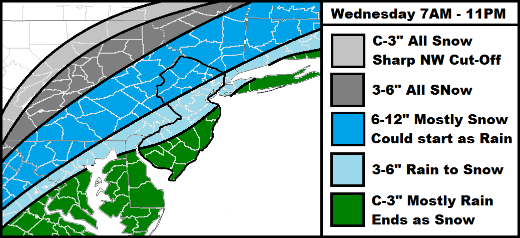
Most regions on this map are straight-forward. The green area should expect mostly rain ending as snow. Only in the last few hours of the storm will there be a chance for anything from flurries/trace accumulations to a few slushy inches away from the ocean. Since the timing of this storm jumped from being a Wed-Thurs storm to now a Wed AM – Wed PM storm, travel should be less impacted on Thursday morning for Thanksgiving. In fact, Thanksgiving day through the weekend looks cool and dry.
Let’s discuss a few observations that can already be made. From watching the storm form in the Gulf of Mexico, I can already tell that cloud tops are very cool on satellite imagery. This means that they are very high in altitude which tells also tells me a lot of moisture is being hoisted into the sky via lifting. As that air mass separates and stretches from the ground up, it cools (physics). This is known as dynamic cooling and is one factor that could lead to greater snowfall amounts. It’s much more common with stronger low pressure systems but 998mb is enough for some to occur.
Another factor that could influence snowfall is called latent heat exchange. When precipitation becomes heavy enough, it brings colder air down with it that squashes warmer surface temperatures. You’ve seen this in the warmer months after a heavy rainfall producing thunderstorm when 90F becomes 75F. During the colder months, 38F and rain can become 31F and snow if precipitation overpowers the warmer lower levels. Since the cloud tops are so high on satellite imagery (as mentioned just before), there is a chance that both factors will be at play and enhance snowfall potential. With no high-latitude blocking (-NAO), the system will be moving by relatively quick so this would need to happen earlier in the storm than later.
Also as you all know, yesterday was very warm and today is pretty mild as well. This has created a warmer layer in the mid-lower levels of the atmosphere. This layer is what will need to be over-powered in order for higher accumulations to happen. I will be focused on this temperature battle-concept for most of now-casting tomorrow as it will have the greatest impact along the I-95 corridor from DC all the way to Boston. The sun angle this time of year is pretty low so that should have little impact this system. Most snowfall could occur during daylight hours but once the sun sets, temperatures will rapidly crash from NW to SE.
Eastern PA and NWNJ are easy forecasts…mostly snow with significant accumulations likely. Coastal and SE New Jersey are just as easy being almost all rain and possibly ending in flurries. The I-95 corridor (and 25 miles to either side of it), however, is an incredibly difficult forecast region to nail down and that’s why you are seeing so many different conflicting maps out there. I’m going a little higher along the 95 corridor (than some other maps out there) because I believe the dynamic cooling and latent heat absorption will have a solid impact. I also believe that just enough cold air will be injected from the Great Lakes system to help make it happen.
In English: Light rain could start as early as midnight tonight. At some point tomorrow morning-afternoon, the rain should switch over to snow from NW to SE and eventually end as snow for everyone. NWNJ has the best chance for accumulations while SENJ has the worst. For everyone in-between, it’s going to be a long day of monitoring surface temperatures for stickage. This is a storm where NWNJ could see a foot of snow while Cape May-Atlantic City sees all rain. I’ll be now-casting through tomorrow. Be safe! JC
Jonathan Carr (JC) is the founder and sole operator of Weather NJ, New Jersey’s largest independent weather reporting agency. Since 2010, Jonathan has provided weather safety discussion and forecasting services for New Jersey and surrounding areas through the web and social media. Originally branded as Severe NJ Weather (before 2014), Weather NJ is proud to bring you accurate and responsible forecast discussion ahead of high-stakes weather scenarios that impact this great garden state of ours. All Weather. All New Jersey.™ Be safe! JC


LOCAL FORECAST | INTERACTIVE RADAR | LATEST NJ WEATHER ALERTS | WEDDING FORECAST| PRIVACY POLICY
© Copyright 2026 Weather NJ LLC. All Rights Reserved.
Some information that can be found on our website is provided by a private weather station and is not an officially recognized station for weather reporting. Though we always strive to achieve accurate reporting for our own use, it is important that you do NOT depend on the data provided here for any purpose.
