

Nov 25: Strong Storm Signal for Next Week
Discussion: The purpose of this article is not to scare anyone to the store for eggs, milk and bread almost a week in-advance of a snowstorm. But rather to inform everyone of a strongly-modeled storm signal, with winter potential, for this coming Saturday night through Monday morning (Nov 30-Dec 2). The best approach IMO is to just keep the possibility of disruption for that time period in-mind. If things are still strongly modeled this Wednesday then it will be time for serious tracking. For now I am much more interested in the upper-level signal than the surface output—which is going to change and vary each model suite. With that said let’s discuss what’s going on.
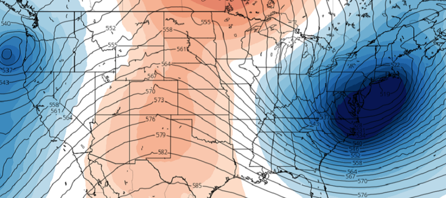
An upper level low within well-below average upper-level geo height anomalies should meander around California from tomorrow night (Tuesday) until about Friday. It will then get caught in the westerly jet stream and head towards the E US between Friday and Saturday with strong cyclonic vorticity. The period of surface impact would be from Saturday night through all of Sunday and into Monday morning. By Monday afternoon the energy should be pulling well-away to the E.
At the lower-levels a surface low should spawn near Arizona on Friday morning and track towards the Great Lakes by Saturday night/Sunday morning—bringing a snow storm to much of the northern-central US. It will then hit a wall (the block), reinforced by high pressure in Canada, which should force a transfer to the coastal ~Delmarva area around mid-day Sunday. From there the low should track somewhere between the 40N/70W benchmark and Cape Cod. This is the most uncertain part of the equation (post-transfer) as many dynamics are involved in the timing and intensity of precipitation.
From the hip right now we are looking at three precipitation phases. First is the initial over-running precipitation that could jump the warm front during the transfer. As of right now this would fall in the Saturday night-Sunday morning period. Once the low transfers to the ~Delmarva coast then we’ll see a torch off the ocean of warmer temperatures. This would mean a changeover to rain by noonish Sunday with rain lasting through Sunday evening. The final piece is then Sunday night into Monday morning as temperatures crash behind the departing low. As of right now there isn’t much precipitation but enough to take seriously especially for NENJ. This system should blow up into a decent snowstorm for coastal New England. The question is…does that ending-colder axis of precipitation reach back far enough for NENJ, possibly other parts of NJ, to end with a snowy thump. The low deepens to sub-990mb on most model guidance so we are likely looking at higher winds regardless of precipitation type.
These are the features I’ll be tracking this week. Everyone please stay calm and just keep the possibility on the table. We’re 2-3 days away from “it’s a go” should the model guidance and live observations hold serve.
In English: A synoptic storm signal is screaming for this Saturday night through Monday morning (Nov 30-Dec 2) meaning a strong chance of an organized storm system impacting New Jersey. As of right now it looks like a snow to rain back to snow situation with a lot of variability. Regardless I am seeing a fair amount of precipitation (whether wet or wintry) and some higher winds. Best not to panic as we have some time to track. Just keep the possibility in-mind for now. Serious tracking will begin Wednesday if the model guidance/live observation status quo is kept. Surface questions will not be addressed until after Wednesday (expected accumulation amounts, etc.) Everyone have a great rest of your Monday and please be safe! JC
Download the new free Weather NJ mobile app on Apple and/or Android. It’s the easiest way to never miss Weather NJ content. Our premium services go even further above and beyond at the hyper-local level. Looking for industrial-caliber long-range forecasting data that I personally recommend? Check out WeatherTrends360!
Jonathan Carr (JC) is the founder and sole operator of Weather NJ, New Jersey’s largest independent weather reporting agency. Since 2010, Jonathan has provided weather safety discussion and forecasting services for New Jersey and surrounding areas through the web and social media. Originally branded as Severe NJ Weather (before 2014), Weather NJ is proud to bring you accurate and responsible forecast discussion ahead of high-stakes weather scenarios that impact this great garden state of ours. All Weather. All New Jersey.™ Be safe! JC


LOCAL FORECAST | INTERACTIVE RADAR | LATEST NJ WEATHER ALERTS | WEDDING FORECAST| PRIVACY POLICY
© Copyright 2026 Weather NJ LLC. All Rights Reserved.
Some information that can be found on our website is provided by a private weather station and is not an officially recognized station for weather reporting. Though we always strive to achieve accurate reporting for our own use, it is important that you do NOT depend on the data provided here for any purpose.
